A Crippling Fall of Very Heavy Snow, With Extreme Snowfall Rates, Is Likely For Friday ( Predawn Into Mid-Day )
*Even the downslope wake zone of the High Knob Massif may have very heavy snowfall during this time period
Please Do Not Travel If Possible
Many Roads May Become Impassible during the Friday Morning to Early Afternoon Period. A Break In Activity Will Be Followed By NE-NW Upslope Flow Snow, With Blowing & Drifting, Dropping Temperatures & Low Wind Chills From Friday Night Into Saturday To Generate Additional Severe Conditions. Travel Is Not Recommended During This Event.
Snowfall Forecast For The January 22-24 AM Period
Very strong LIFT ( Upward Vertical Motion ) will be moving across the region Friday. This has an excellent chance of overwhelming downslope sinking-warming of air in wakes to generate very heavy snowfall during the Sunrise to Early Afternoon Period of Friday.
Wake = the zone of sinking air on the leeward side of major mountain barriers like the High Knob Massif. In this case air will be sinking in locations to its northwest-west-southwest as air flow streams across the massif from the SE-E-NE during this major event before shifting N-NW ( changing the lee wake zone to the south & southeast of the massif and Tennessee Valley Divide ).
Locations in the downstream wake of the High Knob Massif and the Tennessee-North Carolina border, on easterly air flow, will likely have a period of very heavy snow but do remain zones within NE TN and SW VA with the highest uncertainty.
Overnight Into The Predawn
Increasing clouds with snow or a mix developing at onset, changing to snow ( any mix lasting longest in the Powell Valley-Big Stone Gap corridor and adjacent locations in the downstream wake of the High Knob Massif ). Winds becoming E-SE at 5-15 mph, with higher gusts, on ridges-plateaus below 2700 feet. Winds ESE-SE 10-20 mph, with higher gusts, along mountain ridges above 2700 feet. Temps varying from 10s in colder mountain valleys to lower-middle 30s on exposed upper elevation mountain ridges ( temps rising overnight in colder valleys and dropping on ridges following onset of precipitation ).
*The Predawn to Early Afternoon period remains the most uncertain for locations in the downslope wake of the High Knob Massif, with respect to precipitation type. It is very difficult to get snow in Powell Valley on easterly air flow, but if dynamic lift aloft is strong enough and evaporative cooling sufficient it may be able to overcome warming with sinking air into the Valley corridor to generate heavy snow.
If a valley mix of precipitation types continues a TIM Circulation across the High Knob Massif will develop to generate even more extreme snowfall rates in the high country above 3000 feet.
Predawn To Early Afternoon
Snow becoming very heavy. Extreme snowfall rates of 1-3″+ per hour possible during peak of intensity. ESE winds 10-20 mph, with gusts 30-40+ mph at highest elevations. Blowing & drifting snow upon exposed mid to upper elevation mountain ridges & plateaus. Cold with temperatures from upper 10s to mid-upper 20s. Wind chills in single digits & 10s, except below zero on high crestlines of the High Knob Massif ( in gusts ).
Mid-Late Afternoon
Heavy snow diminishing. A break in activity possible before new snow & snow showers redevelop late. ESE to SE winds becoming ENE at 5-15 mph, with higher gusts. Temperatures varying from upper 10s to upper 20s ( coldest at highest elevations ).
Tonight Into Saturday Morning
Snow. Heavy at times. Turning colder. NE winds shifting NNW-NNE at 10-20 mph, with higher gusts, along mid-upper elevation mountain ridges-plateaus. Cloud bases dropping ( possibly into mid elevations ). Temperatures dropping into the 10s along upslope side of mountains, with upper single digits to around 10 degrees at summit level of High Knob Massif. Wind chills dropping into the single digits to low 10s, except 0 to -10 below along upper elevation ridges. Blowing and drifting snow along mid-upper elevation ridges.
*Additional fluffy snow accumulations are likely thru Saturday into Saturday Night and the overnight hours of Sunday along the upslope side of the mountains with respect to northerly air flow. Cloud bases will be low through this period, with continuation of rime formation across upper elevations where heavy amounts are expected to bow small trees.
Weather Discussion ( January 21-22 )
Afternoon Update
It has been quite a day across the mountains. As of mid-afternoon a general 5″ to 10″ of snow had accumulated from the High Knob Massif north & east, with MUCH LESS amid the downslope wake ( shadow zone ) of the massif where 1″ or so has been reported amid the Powell Valley to Big Stone Gap corridor ( with much mixed precipitation ).
New Snow Accumulation In Big Stone Gap ( On Vehicle )
Although not as great as past events ( with a TIM Circulation this time not associated with a pure rain-snow boundary but a snow-mixed boundary ), differences in snow depths and new snow were still very significant through this AM between Big Stone Gap and the High Knob Massif.
Snow Depth In High Chaparral of High Knob Massif – 10:21 AM
The effect has been nicely illustrated this afternoon by some gorgeous views captured via the High Knob Massif Webcam at UVA-Wise, where a break in activity allowed downslope breaks leeward of the great massif in this easterly flow regime to become visible.
High Knob Massif Webcam – University Of Virginia’s College At Wise
While only a tiny portion of the massif is actually visible, upon looking to the left of these views it is possible to see subsidence breaks ( caused by orographically forced sinking air on E winds ).
High Knob Massif Webcam – University Of Virginia’s College At Wise
Following very heavy morning snow, with 1-2″+ or so per hour accumulation rates in parts of the area, the afternoon has featured bands of snow with on-and-off activity.
Large Snowflakes Falling In High Chaparral At 2:27 PM on January 22, 2016
Afternoon bands have been manageable in comparison to the very heavy morning snow which made some roads in the area impassible or nearly so.
High Knob Massif Webcam – University Of Virginia’s College At Wise
Snow began falling atop the High Knob Massif around 2 AM and quickly became heavy, with around 1″ falling in just 30 minutes or so. A little mix may have occurred initially, but the bulk was snow above 3000 feet. The heavy snow spread into Norton-Wise, with more mix-sleet in Norton vs more snow in Wise ( the difference…more sinking air off the mass into Norton on ESE air flow ).
Wind Driven Heavy Snow on Eagle Knob of High Knob Massif
Southwest of Norton, into the Powell Valley to Big Stone Gap corridor, sinking was significant enough to even beat out the very strong upward vertical motion that was developing aloft in the atmosphere.
Slushy Mess In Big Stone Gap at 7:13 AM on January 22, 2016
Once again this illustrates how difficult it is to get just snow, and significant snow, on easterly air flow streaming across the High Knob Massif as I had indicated in my earlier discussions. I should have left my preliminary snow forecast for this zone ( 6″ or Lee ) alone ( of course, this event is not yet over ).
My friend Chris Allgyer reported freezing rain, sleet, and snow all in Big Stone Gap that formed a slushy mess, as the new accumulation above can be seen on his sidewalk ( with lingering snow from the previous event beside the walk ).
My friend Sharon Daniels reported about the same amid the Head of Powell Valley ( around 1″ through the morning ).
Snow In City of Norton At 12:43 PM ( 4″ of Depth ) On January 22, 2016
This effect of sinking air adjacent to the High Knob Massif also impacted snow amounts in Norton, with more mix than in nearby Wise. My friend Sandy Earls measured 4″ of depth at 12:43 PM.
JKL Doppler Reflectivity At 4:20 AM on January 22, 2016
A classic TIM Circulation reflectivity pattern, as viewed from the JKL Doppler, found highest echoes on the Wise County side of the massif that formed, and reformed, over time.
JKL Doppler Reflectivity At 5:23 AM on January 22, 2016
My friend Caleb Ramsey of the City of Norton Water Plant reported 3″ of new snow, with 6″ on the ground, at 9:00 AM after MUCH overnight mixed precip ( NWS 8″-diameter rain gauge total will be given later to illustrate how much mix occurred to contrast with mostly snow high atop the main crest zone of the High Knob Massif ).
As winds shift NE-NW this evening into Saturday snow will increase again across the mountain area with snow in all locations. Snow will become very heavy once again in upslope locations northwest to northeast of the High Knob Massif and Tennessee Valley Divide ( widespread 6″ to 10″+ of additional snow in upslope locations verses 4″ or less in the downslope sites ( e.g., toward the Tri-Cities ).
My Overnight Discussion
An inversion over fresh snow cover in combination with upsloping air flow worked to keep temperatures along and north of the High Knob Massif much cooler during Jan 21 than locations to the south and southeast.
High Knob Massif Webcam – University Of Virginia’s College At Wise
A PM MAX temperature of 28 degrees at the official NWS observation station in Clintwood fell to 15 degrees by 11 PM on January 21, beneath increasing mid-high clouds.
*The MAX temperature in Clintwood being the same as on High Knob during the afternoon, before evening temperature rose on High Knob in warm air advection ( creating a large vertical temp spread across the area between valley and peak ).
These colder temperatures look to play an important role in this storm event, with potential now high for a impressive period of heavy snowfall development into the predawn to mid-day period of this TGIF.
Regional Doppler At 12:58 AM on January 22, 2016
While deep convection over the Deep South can interfere with northward moisture transport, in this case it is not likely to disrupt what is already developing a structure featured in many great winter storms of the past.
USA Water Vapor Image At 12:45 AM on January 22, 2016
My forecast suggests a general 1 to 2 feet of snow will fall across the area, and now has support of nearly all models, with the Friday Night to Saturday period having snow to water ratios ( density ) much lower than the 10:1 used by forecast models. It will be surprising if snow totals do not top 2 feet in the High Knob Massif, with large to massive drifting possible in places along the main crest zone.
What you have on the ground by mid-day to late Friday afternoon will be added to Friday Night through Saturday Night ( with 6″ or MORE of additional snowfall likely for upslope locations on NE-NW air flow ( northerly ).
This snowfall will be low density, fluffy snow and be hard to keep track of as it will blow around over the harder, snow mass on the ground from earlier Friday.
*Upslope locations including Norton-Wise, Pound, Clintwood, all communities along Sandy Ridge and others in Wise & Dickenson and, of course, the High Knob Massif of Wise-Scott-Lee.
While more snow now looks to fall amid wake zones of major mountain barriers like the High Knob Massif and TN-NC border ( in NE Tennessee ), these lee wakes will likely also have the highest probability of power outages due to higher density ( wetter ) snowfall.
Time will tell. That was the trends being shown Thursday. As already noted, it is very hard to get significant snow to accumulate in the Powell Valley to Big Stone Gap corridor when air flow has to cross the wide expanse of the High Knob Massif on easterly air flow trajectories. It will only occur if atmospheric dynamics and thermodynamics can overcome the subsidence warming. Timing and model lift forecast Thursday suggested it would be possible.
As of 2:00 AM snow had started to fall atop the High Knob Massif, so time will soon tell when winds shift easterly and increase if snow will continue to be able to overspread Powell Valley ( amid inverse orographic forcing for the Valley corridor…forced sinking ).
JKL Doppler at 2:33 AM on January 22, 2016
As of 2:30 AM around 1″ or a little more of snow had already accumulated on Eagle Knob of the High Knob Massif amid gusty easterly winds.
NAM 4 KM Model Snow Forecast By 7 PM Friday – January 22, 2016
The NAM 4 KM Model predicts 11″ of snow in Wise by 7 PM Friday, most of that accumulating between Sunrise and early afternoon ( 9″ ).
NAM 12 KM Model Total Snowfall Forecast
The NAM 12 KM has a storm total of 18″ in Wise with a bulls-eye of highest totals centered on the High Knob Massif area with respect to southwestern Virginia.
The ECMWF ( European Model ) continued to replicate previous forcast’s with a snowfall total of 14″ for Wise.
As already noted, all models are under-estimating snowfall amounts amid the cold ( and dendritic ) NE-NW upslope flow during the Friday Night-Saturday Night period.
A Crippling Fall of Very Heavy Snow, With Extreme Snowfall Rates Is High For Friday Morning Into Mid-Day
*Even the downslope wake zone of the High Knob Massif may have very heavy snowfall during this period
Please Do Not Travel If Possible
*My new forecast will be out after Midnight
ALERT For High Impact Winter Storm Development Friday With Potential For Crippling Snowfall Amounts And Possible Power Outages
Snowfall Forecast For January 22-24, 2016 Storm Event
Very strong LIFT ( Upward Vertical Motion ) will be moving across the region Friday. This has a chance of overwhelming downslope sinking-warming of air, and IF it should then heavy ( WET ) snow could develop in the Powell Valley-Big Stone Gap-Lee County and TRI areas to generate more snow than being predicted.
I will likely update my snowfall graphic tonight to include “higher amounts possible” for those subsidence zones in the Powell Valley-Big Stone Gap to Lee County corridor.
The European Model remains rock solid, with consecutive runs of the high-resolution NAM supporting its solution. A major fall of heavy snow is expected Friday in the Norton-Wise and adjacent high country of the High Knob Massif, with mixed precip types amid the Powell Valley-Big Stone Gap corridor extending into portions of southwestern Wise County and Lee County if the dynamic cooling and lift amid the atmosphere does not over-whelm warming with sinking in low-levels on ENE-ESE flow.
All locations will have snow Saturday-Saturday Night as cold air increases across the region on a deep NE-NW flow. This portion of the storm will have low density snow verses a higher density snow during the day Friday.
ALERT For Freezing Fog & Hazardous Walking-Driving Conditions Overnight Into This Morning ( Especially Dense Fog Along and North of the High Knob Massif )
Overnight Into Mid-Morning
Freezing drizzle or fine ( snizzle ) snow. Freezing fog at middle to upper elevations ( especially along and north of the High Knob Massif & Tennessee Valley Divide ). NW to NE winds at 5-15 mph. Temperatures varying from the 10s at highest elevations to the 20s. Wind chills in single digits and teens ( coldest at highest elevations ).
Mid-Morning Through This Afternoon
Decreasing low clouds. Some mid-high clouds possible. Winds NE-E at generally less than 10 mph. Temperatures varying from mid-upper 20s to low 30s ( mid-upper 30s+ only amid locations to the south toward the Tri-Cities ).
Tonight Into Friday Morning
Increasing clouds with snow developing into the predawn-morning. Mix ( sleet, freezing rain, or rain ) developing in Powell Valley to Big Stone Gap corridor. Winds ESE increasing to 5-10 mph below 2700 feet by morning. ESE-SE winds 10-15 mph, with higher gusts, along mountain ridges above 2700 feet. Temperatures generally in the upper 20s to lower 30s.
Weather Discussion ( January 20-21 )
Afternoon Update
This Update is to Heighten My ALERT for Major Winter Storm Development Into Early Friday As Enough Runs Have Now Been Seen To Have Increased Confidence In A High Impact Winter Storm Event.
Storm snowfall predictions from computer model runs on Thursday Morning for the Wise gridpoint vary from 9″ in on the American GFS Model to 14″ on the European Model to 19″ on the high-resolution NAM Model.
NAM 4 KM Model Total Snowfall ForecastGFS Model Total Snowfall Forecast
There is likely to be a huge snowfall gradient across the High Knob Massif area, with the high-resolution NAM trying to see it ( but not fully ).
Local View of NAM 4 KM Model Total Snowfall Forecast
Inversional conditions today, a result of banking of low clouds up against the High Knob Massif & Tennessee Valley Divide into early afternoon ( before finally breaking ), has kept temps above the snow colder in lower elevations with the 2:30 PM temp of 27.5 degrees at Clintwood 1 W being about the same as at the summit level of High Knob.
NASA Visible Satellite At Noon on Thursday
My Overnight Discussion
My forecast during this past day did not need to be updated as it worked out nicely. The main mistake was that I should have expanded my predicted 3″ to 6″+ snowfall zone along the High Knob Landform to include the TRI area due to the expected tendency for lower density snow.
Reference my 012016 Forecast discussion section for details.
*However, as noted on my main forecast page, this site is centered upon the High Knob Landform and Massif area ( e.g., Norton-Wise into Big Stone Gap and Lee-northern Scott counties ) and is not for the TRI area specifically ( where multiple TV & Radio stations, as well as the Morristown National Weather Service Forecast Office, are all located to cover the Great Valley of eastern Tennessee ).
High Knob Massif Webcam – University Of Virginia’s College At Wise
A period of mostly light morning snowfall was followed by heavier afternoon snow. Accumulations ended up being greatest from Lee County southwest toward Norris Lake, with up to 6.5″ of snow depth measured by Harold Jerrell just southeast of Rose Hill in western Lee County.
Northern Cardinals On Cedar Tree In Lee County – Snow Depth 6.5″
Veteran weather observer Denver Garrett measured 4.7″ in the Jonesville area of Lee County.
High Chaparral of High Knob Massif – January 20, 2016
A general 3″ to 5″ of new snow accumulated across the High Knob Massif where totals actually came in on the low end of the forecast range ( for a change ). Some blowing & drifting was noted amid the main crest zone surrounding the peak of High Knob during the afternoon.
Chris & Paxton Allgyer measured 3″ of snow depth in Big Stone Gap which was about the same as Darlene Fields in the High Chaparral community of the High Knob Massif ( that seldom occurs ).
High Knob Massif Webcam – University Of Virginia’s College At Wise
Between 2″ and 3″ of new snow fell in the Clintwood area with officially 3″ on the ground at my station just before sunset when some large snowflakes were falling ( later transitioning to a very fine drizzle-like snow that I call snizzle ).
Lonesome Pine Airport In Wise
Clouds bases have dropped into middle elevations along and north of the High Knob Massif tonight, with freezing drizzle and very fine, drizzle-like snow.
Focus now shifts toward a major winter storm event that is timed to begin into the predawn hours of Friday. Specific details such as the nature of the surface low track and the transfer of its energy to the Atlantic Coast will be critical and may not be resolved fully until later today.
Generalized European Model 51-Member Ensemble Mean Track
The European Model has remained extremely consistent in taking a surface low from Louisiana into northern Alabama before a rapid transfer & reformation over South Carolina by late Friday. Such a track would keep colder air in place over the area and allow for more snowfall.
The NAM & GFS Models ( especially GFS Model ) allow more warm air to work up along the western slopes of the Appalachians via more downsloping along the TN-NC border.
The new European run tonight continues to be consistent with the above Ensembles track and predicts 14″ of snow to fall at the Wise gridpoint during this storm event ( 10″ of that falling between the predawn to 7:00 PM of Friday ).
*If the above verified, snowfall would be greater since the comma-head snow amid the backside, NW-NE upslope flow period, would have a lower density and produce more snow than the model says.
NAM 4 KM Model Total Snowfall Forecast Next 60-Hrs ( 1 AM Run on Jan 21 )
This high-resolution NAM 4 KM Model run is very interesting in that it shows the deformation zone band very well across KY into the HTS-CRW region of West Virginia and is also trying to capture the downslope and sinking amid the wake zone of the Cumberland Mountains with respect to easterly air flow trajectories.
The model is just not able to fully resolve that immediately amid and adjacent to the High Knob Massif where a TIM Circulation forms to greatly enhance precipitation amounts ( i.e., snow amid the high country and mix in the wake zone with subsidence ).
NAM 4 KM Model Total Snowfall Forecast Next 60-Hours
The latest high-resolution NAM 4 KM Model has duplicated the European Model solution with 14″ also being predicted for the Wise gridpoint through 60-hours ( some more falls beyond this time on N-NW upslope flow ).
This type of flow field would generate a TIM Circulation across the High Knob Massif with a very large snowfall gradient setting up along and downstream of the massif amid its wake zone with respect to ENE-ESE air flow.
A featured I’ve documented numerous times since the infamous January 1998 episode that unofficially set a new 24-hour snowfall record for the Old Dominion when 36″ to 40″+ of snow accumulated amid upper elevations of the High Knob Massif in only 21-hours.
A Miller A Inland Variant Track – Single Low Tracks Far To South & East
The January 1998 and December 2009 events, which crippled the mountain area with power outages & snow depth, were Miller A cyclones ( inland variants ).
This event is not a classic Miller A, and does have a Miller B tendency which tends to reduce snowfall along the western slopes of the southern Appalachians ( and at times across all of the southern Appalachians ).
Miller B Climatology – A Double Low With Transfer of Energy To Coast
So the key to this forecast setting will be how much it favors Miller B verses Miller A ( to make it simple ) from a climatological perspective.
The European Model’s consistent solution of not bringing a surface low north of the southern Tennessee – SW North Carolina area will keep colder air across southwestern Virginia and generate more total snowfall verses a surface low that moves farther northeast up the Tennessee Valley before transfer of energy to the Coast.
*The huge snowfall gradient that I have on my forecast snow graphic at the beginning of this page would hold in the ECMWF solution. If the solution goes more toward classic Miller B; however, amounts would be reduced significantly at all sites.
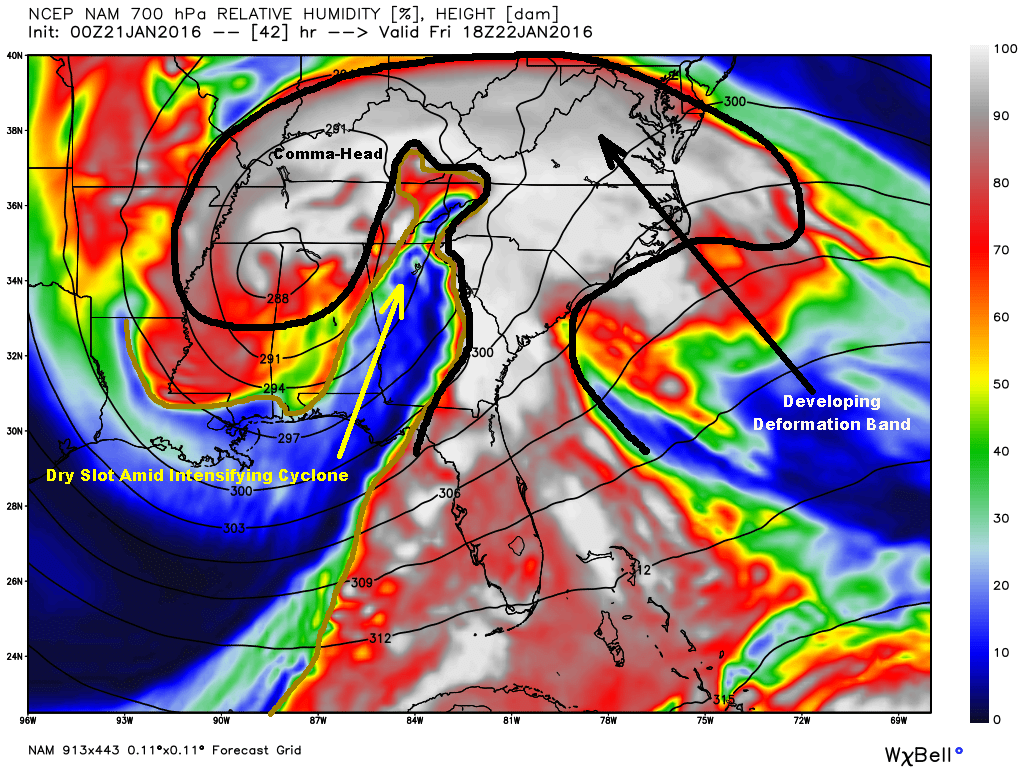
Dry Slot of Intensifying Cyclone – NAM Model Forecast At 1 PM Friday
Another critical difference between the European and American models, as well, is the 700 MB dry slot that works into the area during the formation of a large comma-head and deformation zone. The dry slot is a little longer lived and more pronounced on the American models than it is on the European over this area ( where it is a brief intrusion that rapidly gets advected off toward the east ).
NAM 12 KM Model Total Snowfall Forecast
Even with the dry slot ending precipitation for a time late Friday, the NAM Model still predicts more than a foot of snow across the Cumberland Mountains ( missing fine details of the terrain ).
There are multiple mechanisms at work in this event:
1 ). Isentropic Lifting
( Warm Conveyor Belt )
2 ). Orographic Forcing
( Mesoscale Features )
3 ). Dry Slot Formation
( Signal of Intensifying Cyclone )
3 ). Deformation Zone
( Enhanced Lifting )
4 ). Comma-Head N-NW Flow
( Cold Conveyor Belt )
These and other features look to phase best from the central Virginia-West Virginia border area northeast into northern Virginia and portions of adjoining states. However, the local potential remains very significant as I have well documented within past climatology.
Needless to say, this storm has huge potential and my next forecast will be critical as by then it should be known if the European solution is going to verify.
Since today is the last day we have to prepare, please do anything necessary to keep you and your family safe during a potentially major event that could include power outages and deep snow depths.
ALERT For The Development Of Accumulating Snow And Hazardous Travel & Walking Conditions
*Due to prolonged bitter temperatures hazardous driving and walking conditions will quickly develop across the region today. Extreme Caution Is Advised.
It would be best for county schools to close today before getting any buses on roadways ( recommended, with each county having to make their own decision ).
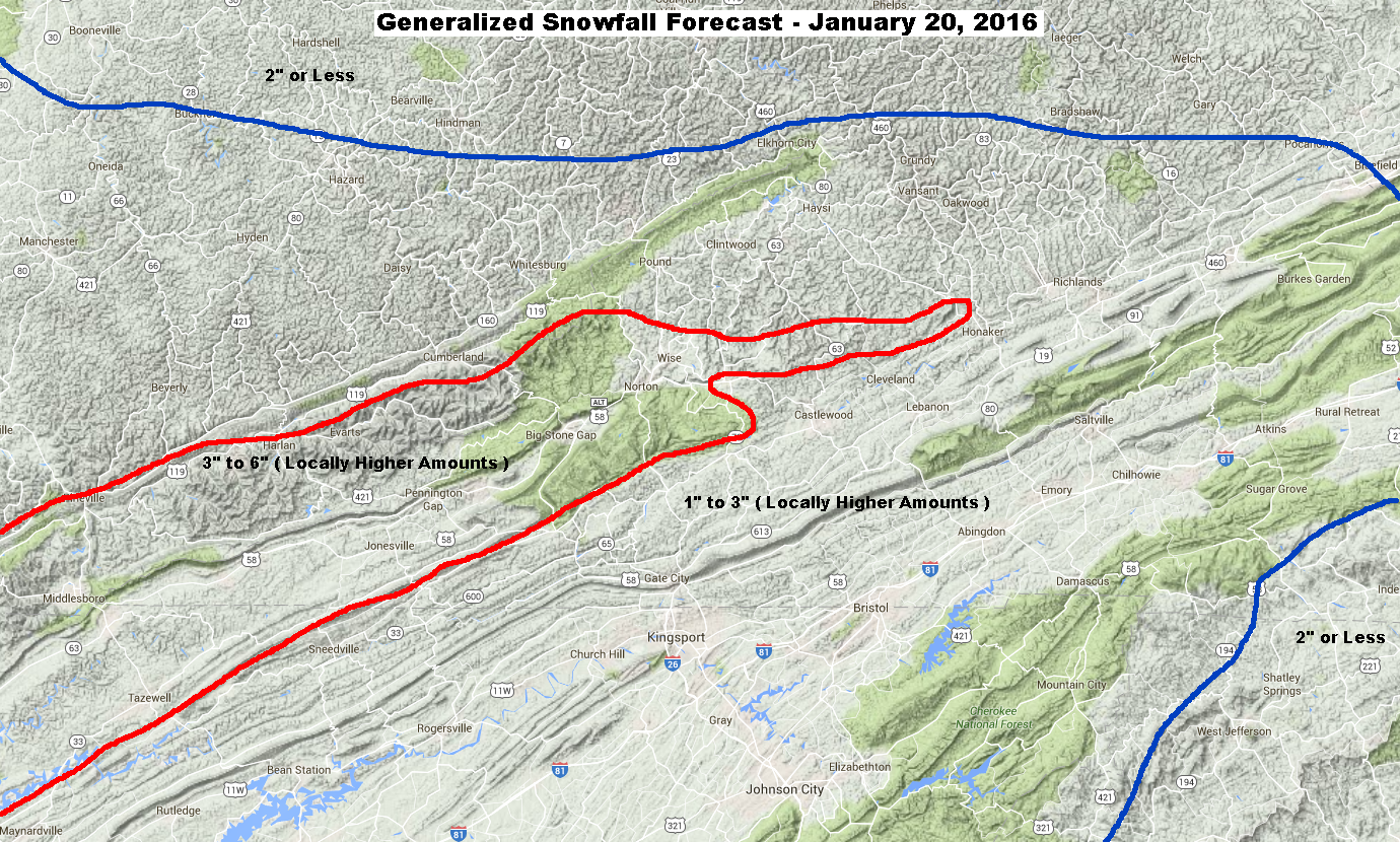
Generalized Snowfall Forecast For January 20, 2016
Specific Snowfall Forecast
2″ to 4″ Russell Fork Basin ( Pound – Clintwood – Haysi )
3″ to 6″ Upper Tennessee Basin ( Norton – Wise – Big Stone Gap )
4″ to 8″ Above 3000 Feet ( High Knob Massif )
Target Snowfall of 4″ In Norton-Wise ( +/- ) 1″ Error Potential. This implies a chance for 3″ to 5″ of snow accumulation.
A general depth of 4″ or more is expected to develop above 3000 feet elevation in the High Knob Massif, with a target snowfall of 6″ at 3500 feet ( +/- ) 2″ Error Potential. This implies the chance for 4-8″ of snow depth above 3000 feet in the High Knob Massif.
Potential Of A Major Winter Storm Is Increasing For The January 22-24 Period. This Could Be A Crippling Winter Storm Event And Will Need To Be Closely Followed During The Next 24-48 Hours.
Overnight Into This Morning
Increasing clouds. Light snow developing. Light & variable winds becoming S to SSW at less than 10 mph on mountain ridges & plateaus below 2700 feet. Winds becoming SSW to WSW at 10-20 mph, with higher gusts, along mountain ridges above 2700 feet. Wind chills in the single digits, except locally below zero on highest mountain ridges.
Temperatures in the single digits ( mountain valleys ) to mid 10s ( mountain ridges and plateaus ) will tend to rise into the predawn-morning.
Mid-Morning Through This Afternoon
Snow. Becoming moderate to heavy into the afternoon. SSW-W winds of 5-15 mph below 2700 feet. Winds SW-WNW at 10-20 mph, with higher gusts, above 2700 feet. Temperatures mostly in the 20s ( lower 30s possible IF mixing can develop into lower elevations ).
Tonight Into Thursday Morning
Snow to snow showers & flurries before ending. Low clouds. W winds at 5 to 15 mph shifting N to NNE into morning and decreasing to 10 mph or less ( possible cloud base drop into middle elevations ). Temperatures varying from the 10s at highest elevations to the 20s.
*Lingering low-level moisture could allow cloud bases to drop into the middle elevations, with a freezing fog potential, for a period of time during the predawn-morning hours of Thursday on upsloping northerly air flow ( generally from the elevation of Wise upward ) for locations along & north of the High Knob Massif and Tennessee Valley Divide ( e.g., Black-Hazel-Big A mountains ).
Weather Discussion ( January 19-20 )
Another bitter day was observed during January 19 with afternoon MAX temperatures varying from 10 degrees at the summit level of the High Knob Massif to 18 degrees within the deep mountain hollow at Clintwood 1 W.
High Knob Massif Webcam – University Of Virginia’s College At Wise
Before clearing skies into afternoon a low cloud deck generated light snow within the upslope corridor from the High Knob Massif north across Norton-Wise to Pound-Clintwood ( on NW winds ).
Light snow accumulations of from 0.1″ to 0.3″ were common during the 6-hour or so period with falling flakes as a little upslope combined with a bit of moisture from Lake Michigan.
Nora 4 SSE on Long Ridge – MAX Temperature of 16 degrees at 2650 feet
Temperatures fell off into single digits amid mountain valleys during evening hours of January 19, beneath clear skies, to contrast with near steady or slowly rising temps across exposed mid-upper elevation mountain ridges.
European Model 850 MB Temps & Surface Pattern At 7 PM – January 19, 2016
Focus now shifts to a disturbance ( lead wave ahead of the MAIN EVENT ) across the Mississippi Valley that will be moving into this mass of Arctic air.
This wave will be dampening over time, thus its influence will be least along the eastern side of the Appalachians and greatest along the western side of the mountain chain.
Precipitation today will be driven by warm air advection and isentropic lifting, with a period of SW air flow up the High Knob Landform corridor expected to enhance snow amounts above the generalized 1-3″ that is expected across the region ( higher end totals likely being realized in this case amid the region in general since past climatology well dictates that it takes a while for snow densities to rise up toward 10:1; therefore, model QPF will be able to generate more snow than strict 10:1 ratios ).
**So two aspects may need to be tweaked today. Snowfall amounts, which I have already done in an upward manner, as well as temperatures with a very cold start to the day being covered by clouds in combination with onset of strong evaporative cooling.
The battle between warm air advection and evaporative cooling ultimately acting to dictate temperatures today. If evaporation generates an inversion then gusty winds aloft will tend to flow over the top and temperatures at lower-middle elevations will tend to be colder than if vertical mixing occurs ( which then can work to warm lower-levels, especially those under downslope ).
NAM 12 KM Model Total Precipitation Forecast
The NAM Model is very close to the European on total precipitation amounts ( both models generating snowfall totals using a 10:1 ratio ); therefore, it is likely that if these models are correct that snow amounts will be somewhat higher than they suggest given past climatology of WAA and moisture transport into true arctic air masses.
WAA = Warm Air Advection
If the models are over-estimating precipitation amounts, then snow totals could end up being close to what they show or even lower than they are predicting. One reason that I always have a ERROR Potential factored into my snowfall forecast’s.
No forecast model is absolutely correct ( one has to adjust as past climatology dictates, then choose the least “wrong” solution )!
NAM 12 KM Model Total Snowfall Forecast
The system today, regardless of final snow amounts, is going to cause widespread hazardous travel across the Mountain Empire and will catch many off-guard if not expecting this. WHY would you not, given days of bitter temperatures have everything frozen.
Major Winter Storm Upcoming
Although the event today will no doubt cause its share of travel troubles, especially in the Tri-Cities area of NE TN, and the Great Valley in general, where significant falls of snow are MUCH less common than here in the mountains, it will be nothing compared to what may be ahead if model trends during recent days are correct.
NAM Model 500 MB Forecast At 7:00 AM on Friday – January 22, 2016
Just look at what upper diffluence is being generated by early Friday in advance of a developing upper low that will be “closing off” above the southern Appalachians. The NAM Model trend is following the European which has been the lead model in showing a progressively more southern track.
When I say upper diffluence, I am referring to the way the black isobars at 500 MB ( about 17,000 feet up ) spread outward & separate above our area, like pulling your hands apart in a bath-tub or pool. Air from below this level is sucked upward ( like in a vacuum cleaner or chimney ) through the atmosphere to generate strong condensation, cooling, and precipitation. Always a sign of heavy precipitation when copious moisture is present.
If nothing changed from runs tonight I would be forecasting that a TIM Circulation will develop across the High Knob Massif amid the period of easterly flow. That would CRANK the high country snow and generate a huge local difference with mix likely in the Powell Valley to Big Stone Gap to Lee County corridor with MUCH less snow during that period of the event ( then NE-NW flow would develop to crank upslope on northerly air flow trajectories ).
Reference TIM Circulation for more information on a mesoscale feature indigenous to the great High Knob Massif. Responsible for simply amazing snowfall rates and deep falls that typically would not be expected on the western side of the Appalachians during events which tend to favor eastern slope locations with CAD.
CAD = Cold Air Damming in reference to eastern slopes
A big worry, of course, would be development of an isothermal layer such as observed during the great storms in January 1998 and December 2009 which crippled the mountain area with power outages and snow depths. Needless to say, this is one to begin to take seriously now. Stay tuned for updates.
ALERT For Continuation of Dangerously Cold Conditions Through This Morning
High country lakes will freeze over during this event, as will many ponds & slow running creeks. Caution Is Advised as ice may not become thick enough to walk across safely.
Accumulating Snow Is Likely For Wednesday With Hazardous Travel Conditions Expected. Prepare Now.
Potential Of A Major Winter Storm Is Increasing For The January 22-23 Period. Stay Tuned For Details.
Overnight Into Mid-Morning
Increasing clouds overnight into morning ( especially in upslope locations ) with a chance of flurries and light snow showers. A dusting or light accumulation in places. Bitter cold. WNW-NW winds 5-15 mph, with higher gusts along mid-upper elevation mountain ridges. Temps in the single digits above and below zero ( coldest at highest elevations ). Wind chills 0 to -15 below zero along middle elevation ridges and plateaus below 2700 feet, with chill factors of -10 to -25 below zero on ridges above 2700 feet.
Mid-Morning Through This Afternoon
Any flurries ending. Becoming partly to mostly sunny. WNW-N winds decreasing to generally less than 10 mph. Temperatures varying from around 10 degrees at highest elevations to upper 10s-lower 20s ( milder in snow-free valleys of the Clinch, Powell, and Holston river basins toward the Tri-Cities ). Wind chills single digits and 10s.
*Tonight Into Wednesday Morning
Increasing clouds overnight into morning. Light & variable winds becoming S-SSW by morning at less than 10 mph on mountain ridges & plateaus below 2700 ft. Winds becoming SSW-WSW at 5-15 mph, with higher gusts, along mountain ridges above 2700 feet. Temperatures varying from upper single digits to lower 10s in mountain valleys with calm winds into early overnight, rising toward dawn. Temps generally rising into 10s & 20s across exposed middle to upper elevation mountain ridges and plateaus.
*Accumulating snow is likely to develop during the day.
Weather Discussion ( January 18-19 )
Bitterly cold conditions dominated January 18 from start to finish, with MAX temperatures varying by elevation & snow cover from 17 degrees at the 1560 feet elevation of the NWS Cooperative Station in Clintwood to only 6 degrees at the summit level of the rime coated High Knob Massif.
Temperatures rising a little higher within snow-free valleys amid the Clinch, Powell, and Holston river basins where many places were able to reach into the 20s.
High Knob Massif Webcam – University Of Virginia’s College At Wise
Wind chills were a significant factor across middle to upper elevation mountain ridges and plateaus, with 0 to -25 below values throughout the day ( coldest at highest elevations ).
Nora 4 SSE – Along The Tennessee Valley DivideEuropean Model 850 MB Temps & Surface Pattern At 7 AM Monday
Temperatures tonight have again dropped below zero along crest lines of the High Knob Massif and Black Mountain, and in a few of the high valleys amid the snow covered massif. Widespread single digit to near zero degree temps ( e.g., Norton valley ) are common in lower-middle elevations of the area at 2:00 to 3:00 AM Tuesday.
European Model 850 MB Temps & Surface Pattern At 7 PM Monday
The temperature drop is being checked a bit by low clouds which have formed on WNW upslope flow tonight into the windward slopes of the High Knob Massif and Tennessee Valley Divide. Some snowflakes are being observed on Eagle Knob of the High Knob Massif.
*Cloud bases have actually formed below the summit level of the massif where some more riming may occur amid this bitter air.
NAM Model 925 MB RH and Wind Streamline Forecast at 10:00 AM Tuesday
These developments were expected with a little bit of Great Lake moisture flowing into windward slopes through mid-morning today. This is now generating some light snow and flurries ( and narrow snowstreaks ) along the upslope side of the mountains ( with respect to WNW-NW flow ) from Clintwood & Pound into the High Knob Massif. A dusting or light accumulation will be possible in places through about mid-morning or so when low clouds will begin to dissipate.
JKL Doppler Showing Light Snow & Snowstreaks
Higher altitude clouds will begin to increase later today into tonight in advance of the next snow maker.
I will post a snowfall projection for this event in my next forecast. Preliminary indications suggest that several inches of snow may accumulate within the SW Upslope Flow corridor of the High Knob Landform ( a warm air advection type as documented many times in the past ).
ALERT For Dangerously Cold Conditions Monday & Tuesday With Bitter Temperatures and Wind Chills Amid The Coldest Air Mass Since Last February
Once Air Temperatures Drop Below 20 degrees In Norton-Wise tonight, they may not rise above 20 degrees ( for any length of time ) until Wednesday. They will certainly not rise above 20 degrees for those living on northern slopes. Snow cover of 1-3″, or more in spots, will make conditions colder within locations having snow on the ground.
***Remember to dress warmly and to plan not to be outdoors longer than necessary. Check on our elderly residents, take measures to protect pets ( e.g., horses, dogs, cats etc…need shelter from the cold & wind as well as ice free water ).
Temperatures at the High Knob Lookout will drop below zero tonight, rise only into single digits Monday and go below zero again into Tuesday Morning. Wind Chills will be EXTREME. Travel & visitation to there is not recommended.
High country lakes will freeze over during this event, as will many ponds & slow running creeks. Caution Is Advised as ice may not become thick enough to walk across safely.
Turning bitterly cold. Scattered snow showers & flurries diminishing overnight into the predawn. Temperatures plunging to -4 to 8 above zero into the overnight-morning hours ( somewhat “milder” in valleys leeward of the High Knob Massif and Cumberland range ). Wind chills varying from 5 above to -10 below zero across mid elevation ridges & plateaus, with -10 to -25 degree below zero wind chills in upper elevations above 3000 feet.
*Note that the air will become so bitter than any passing cloud can still generate flurries today; although, I will call for mostly sunny skies after any morning clouds evaporate amid drying air.
This Afternoon
Mostly sunny & bitter. WNW winds 5-15 mph, with higher gusts ( especially at higher elevations ). Temperatures in the single digits and teens ( topping 20 degrees officially only in “milder” snow-free valleys amid river basins of the Clinch, Powell, and Holston ). Bitter wind chill factors of from 0 to 12 degrees at elevations below 2700 feet, and from 0 to -15 below zero across upper elevations.
Tonight Into Tuesday Morning
Mostly clear in the evening with some increasing clouds overnight into morning ( especially in upslope locales ). Bitter cold. WNW-NW winds 5-15 mph, with higher gusts along mid-upper elevation mountain ridges. Temperatures in the single digits above and below zero ( coldest at the highest elevations ). Wind chills 0 to -15 below zero along middle elevation ridges and plateaus below 2700 feet, with chill factors of -10 to -25 below zero on ridges above 2700 ft.
Two important systems are being watched for wintry potential this coming week. The weaker first system is currently timed to arrive Wednesday ( January 20 ).
A second, potentially Major Winter Storm system, is currently timed to impact the region during the period from Thursday into Saturday ( January 21-23 ).
A third system, in a series, of potential concern may develop during the January 25-27 period.
Stay tuned for updates.
Weather Discussion ( January 17-18 )
Afternoon Update – A BITTER ONE
Although sunshine finally returned to rule the afternoon it has been a bitter one. Let’s check out a few RAW statistics!
High Knob Massif Webcam – University of Virginia’s College At Wise
PM MAXS as of 3:30 PM included:
Clintwood 1 W: 17 degrees
Elevation 1560 feet
City of Norton WP: 14 degrees
Elevation 2342 feet
Nora 4 SSE on Long Ridge: 12 degrees
Elevation 2650 feet
Black Mountain MesoNET: 7 degrees
Elevation 4031 feet
Joe Carter of the City of Norton Water Plant reported the daytime MAX of 14 degrees at 3:30 PM. At the same time, some 1800+ vertical feet above the city the temperature was 5 degrees on High Knob ( wind chill of -12 below ).
Nora 4 SSE – Site of Official National Weather Service Station
All of a sudden, or so it seems, a very active Janaury weather pattern has developed. Two different systems impacted the mountain region just during January 17.
ECMWF Model 850 MB & Surface Pattern At 7 AM on January 17, 2016
The morning initialization by the ECMWF Model was rather impressive looking, with a well developed cyclone that was responsible for killer tornadoes in Florida.
This storm system being just outside of the snowstorm “strike zone” ( as in baseball ) for the southern Appalachians. Almost in need of instant replay, but not quite ( it was close and a wanna-be snowstorm for certain ).
The first was a far southward tracking southern system that only brushed the southern Appalachians. A general 0.5″, or a bit more, of snow accumulation was measured from the City of Norton Water Plant into Wise, Pound, and Clintwood during a period of morning snowfall supported by weak northerly upslope flow and some divergence aloft.
Snowfall came in on the low end of my forecast range for the Great Valley of eastern Tennessee and the Blue Ridge province across western North Carolina into southern Virginia, with generally a dusting to 1″ being reported.
High Knob Massif Webcam – University of Virginia’s College At Wise
The High Knob Massif was majestically rime coated but only partially visible at times, especially late in the afternoon, as cloud bases lifted in advance of a approaching Arctic Front.
High Knob Massif Webcam – University of Virginia’s College At Wise
This front was the real deal, as I expected, with whiteout conditions developing from Pound & Clintwood into Wise and the City of Norton to Appalachia during the 9:30 PM to 10:00 PM period. This was a wind driven and vigorous line of snow squalls featuring graupel snow at times, as well as large dendrites. Widespread snow accumulations of 1″ or more occurred ( a low density, fluffy snow in general ) to bring the official NWS snowfall total to 2.2″ in Clintwood for this day ( at an elevation of 1560 feet ).
Widespread and hazardous road conditions developed along the entire U.S. 23 corridor from Pound Gap to Little Stone Mountain Gap, as well as along adjoining roads such as Route 83.
Some drifting occurred in the High Knob Massif where sub-zero wind chill factors accompanied the heavy snow to create truly wicked conditions.
ECMWF Model 850 MB & Surface Pattern At 7 PM on January 17, 2016
Focus now shifts to a huge mass of true, arctic air that will engulf the mountain region in bitter air through today and Tuesday. The coldest air mass since February 2015.
Although the entire region will be bitter, I expect snow covered locations to be colder during the Monday-Tuesday period as snow helps to chill this low-level air even more with northern slope sites being especially bitter.
Several systems are lined up to impact the mountain region during the next 7 days, so stay tuned for updates on this active mid-late January pattern.
*NOTE: Intense Snow Squalls With Whiteout Conditions For A Period Of Time Are Beginning To Push Across The Virginia-Kentucky Border And Will Impact The U.S. 23 Corridor From Pound Gap Into Norton-Wise-Clintwood Between Now And 10:30 PM
ALERT For Redevelopment Of Snow Showers Tonight With A Snow Burst Potential Along An Arctic Front Sunday Evening ( Around 9:00 PM For Norton-Wise Give Or Take An Hour ) – Followed by Plunging Temps And Wind Chills To Bitterly Cold Levels Into Monday
ALERT For Dangerously Cold Conditions Monday & Tuesday With Bitter Temperatures and Wind Chills Amid The Coldest Air Mass Since Last February
Once Air Temperatures Drop Below 20 degrees In Norton-Wise tonight, they may not rise above 20 degrees ( for any length of time ) until Wednesday. They will certainly not rise above 20 degrees for those living on northern slopes. Snow cover of 0.5-1″ or more will make conditions colder within locations having snow on the ground.
***Remember to dress warmly and to plan not to be outdoors longer than necessary. Check on our elderly residents, take measures to protect pets ( e.g., horses, dogs, cats etc…need shelter from the cold & wind as well as ice free water ).
Temperatures at the High Knob Lookout will drop below zero tonight, rise only into single digits Monday and go below zero again into Tuesday Morning. Wind Chills will be EXTREME. Travel & visitation to there is not recommended.
High country lakes will freeze over during this event, as will many ponds & slow running creeks. Caution Is Advised as ice may not become thick enough to walk across safely.
A chance of snow developing during the predawn to sunrise period. An interval of moderate snow possible. Light NNE-NW winds at generally less than 10 mph. Temps varying from upper 10s ( at highest elevations ) to the upper 20s. Wind chills in the 10s & 20s, with some single digits at highest elevations.
Mid-Morning Through This Afternoon
Any snow tapering to flurries and ending. Skies may briefly become partly-mostly cloudy ahead of an arctic front by late. Winds W to WNW at 5-15 mph, with higher gusts. Temps varying from 20s to middle 30s ( warmest lee of mountains toward the Tri-Cities ). Wind chills in the 10s and 20s ( coldest at highest elevations with single digits ).
Early Evening Into Monday Morning
Flurries and snow showers developing. An evening burst of heavy snow ( whiteout conditions ) possible. Winds WNW at 10 to 20 mph, with gusts to 30+ mph. Turning bitterly cold with temperatures plunging to -2 to 12 above zero into the overnight-morning hours. Wind chills from 5 above to -10 below zero across middle elevation ridges & plateaus, with -10 to -25 degree below zero wind chills above 3000 feet.
General 1-2″ East of Rose Hill In Southwestern Virginia
General 0.5-1.5″ In Clinch, Powell, Holston River Valleys
Target Snowfall of 1.5″ in the Norton-Wise area ( +/- 1″ ) Error Potential. This implies a potential from 0.5″ to 2.5″ and includes Sunday AM snow and Sunday Evening-Night snow ( with melting in between ). Extremes of from a trace along and west of a Rose Hill to Pikeville line up to 3″ in the High Knob Massif ( from both events ) are possible. Note that snow depths may never get as deep as total snowfall with afternoon melting of any AM snow ( especially southern exposed slopes & across lower elevations ).
While forecast models predict most places to have 1″ or LESS of snow, these graphics show the potential range when considering the current weather setting, terrain features & orographics, plus past climatology of similar such events. Regardless of amounts, this is to be a relatively minor system but one that can cause roads to become slick and hazardous. The bigger story, ultimately, will be dangerously cold wind chills and air temperatures arriving by later tonight into Monday ( when Arctic sunshine returns ).
Snowfall Totals For Entire Event ( AM and Tonight )Generalized Snow Burst Potential Map
While not all locations will have a whiteout, these zones ( inside the RED ) have the greatest potential for a whiteout type of snow burst along the Arctic Front during Sunday Evening – especially locations along and northwest-north of the High Knob Massif.
Zone With Greatest Potential Of A Sunday Evening Whiteout Burst
My Weather Discussion ( January 16-17 )
Afternoon Update
A period of morning snow deposited around 0.5″ or a little more of accumulation in the Norton-Wise area, with about the same in Clintwood ( 1″ on the ground ).
Morning snow, using time lapse video, appeared to stick but quickly melted down in the Great Valley and Tri-Cities.
High Knob Massif Webcam – University of Virginia’s College At Wise
The High Knob Massif is looking majestic when it emerges from clouds with riming, above 3000 feet, for many miles. After rising to lower 20s air temperatures have dropped into the upper 10s at summit levels of the High Knob Massif and Black Mountain.
The only change to my forecast in this update is to note that any brief break in clouds may be late ( or perhaps not at all ) as the Arctic Front cloud band has about caught up with clouds lingering in wake of the morning system.
NASA Visible Satellite and Doppler Overlay
Observe how the cloud break ( over central Kentucky above ) has just about filled in now ( below ) as it approaches the mountains.
NASA Visible Satellite and Doppler Overlay
Observe also the snow showers developing along the Arctic Front to the west and northwest. Those are the ones that I expect to bring a snow burst to the area this evening.
Current timing is between 7 PM and Midnight, centered around 9:00 PM for the Norton-Wise area ( give or take an hour ). These will bring very bad road conditions with local whiteouts and a rapid covering of snow amid strong, gusty winds and falling temps. Since yet again they do not have a good Great Lake connection, these will be brief in nature.
HRRR Model Future Doppler Forecast At 9:00 PM
My Overnight Discussion
Air turned colder during Saturday with low clouds again trapped beneath an inversion layer. Dense fog changed to freezing fog across upper elevations of the High Knob Massif where rime formation got underway.
Riming On Eagle Knob of High Knob Massif
While a little light snow coated roads amid the High Knob Massif in some upper elevation places, snowfall was more active to the north where several snowstreaks developed along Pine Mountain and extended across the Pound to Clintwood corridor of northern Wise County and Dickenson County.
Around 0.5″ of Snow Accumulation In Clintwood at 6:59 PM Saturday
Visibility dropped to less than 1 mile with light to moderate snow around and just after sunset. I measured 0.5″ at my elevation of 1560 feet ( so more accumulated amid these snowstreaks at elevations above 2000-3000 feet ).
Accumulation Following Light-Moderate Snow In Clintwood on Saturday
Reference the afternoon update in my 011616 Forecast discussion.
The productivity of these late afternoon snowstreaks is one reason I have gone above model output somewhat for this area, with such abundant low-level moisture lingering and poised to be precipitated out with any substantial lifting.
HRRR Model MSLP And Wind Streamline Forecast – Weak NW Upslope Flow
The speed of this system goes against any greater amounts and may make it difficult to achieve predicted totals without a period of at least moderate snowfall ( note that forecasted snowfall also includes what comes along a vigorous Arctic Front this evening ).
HRRR Model Future Doppler Forecast For 8 AM This Morning
The latest HRRR Model future Doppler forecast shows snow becoming widespread during the 5 AM to 8 AM period, but ending in the Norton-Wise area between 10-11 AM. As with the previous rain system, there will tend to be a sharp cut off of snow along the western edge ( with LESS being the prime word for my snowfall graphic above to the west of Rose Hill in Lee County ).
Many places will likely have some melting of snow into this afternoon amid a break between this system and the bitter blast of air upstream.
Bitter air pours into the mountain area tonight into Monday, and I will update that and the potential of a snow burst along the Arctic Front later today.
Upper Falls of Little Stony Gorge of High Knob Massif – December 26
December 2015 was all about wetness and anomalously mild temperatures, with a general 7.00″ to 11.00″ of total precip across the great High Knob Massif.
Middle Falls of Little Stony Gorge of High Knob Massif – December 26
Water plants for the City of Norton and Town of Big Stone Gap both recorded 21 days of measurable precipitation during the month. No wonder whitewater gushed out of the high country.
Big Cherry Lake In Orographic Clouds of High Knob Massif – December 17
Superintendent Gary Hampton, of the Big Stone Gap WP measured ( with a little help from me ) a total of 10.45″ of December precipitation at Big Cherry Dam.
Whitewater Gushes In South Fork Gorge of High Knob Massif – December 3
Gary measured 5.29″ just during December 24-30, as much as reported in Burkes Garden during the entire month of December and significantly more than measured at several official sites.
Climate Statistics For December 2015
( Lower Elevations of Russell Fork Basin )
Clintwood 1 W – Elevation 1560 feet
Average Daily MAX: 57.6 degrees
Average Daily MIN: 35.4 degrees
MEAN: 46.5 degrees
MAX Temperature: 73 degrees
MIN Temperature: 19 degrees
Total Precipitation: 5.24″
2015 Precipitaton: 49.79″
( Northern Base of High Knob Massif )
Cit of Norton – Elevation 2141 feet
Average Daily MAX: 54.9 degrees
Average Daily MIN: 34.6 degrees
MEAN: 44.8 degrees
MAX Temperature: 68 degrees
MIN Temperature: 16 degrees
Total Precipitation: 6.70″
2015 Precipitation: 64.30″
( Along the Tennessee Valley Divide )
Nora 4 SSE – Elevation 2650 feet
Average Daily MAX: 55.0 degrees
Average Daily MIN: 42.6 degrees
MEAN: 48.8 degrees
MAX Temperature: 70 degrees
MIN Temperature: 20 degrees
Total Precipitation: 4.51″
2015 Precipitation: 47.01″
Rock In Upturned Tree – Middle Falls of Little Stony Gorge
A Few December Totals Across Southwestern Virginia
Nora 4 SSE
4.51″
Grundy
4.57″
Richlands
4.70″
Lebanon
4.98″
Clintwood 1 W
5.24″
Wise 3 E
5.25″
Burkes Garden
5.29″
Blacksburg NWSFO
5.51″
Wytheville 1 S
5.72″
Dungannon
6.32″
City of Norton Water Plant
6.70″
Big Stone Gap WWTP
7.71″
Big Stone Gap Water Plant
9.42″
Big Cherry Lake Dam
10.45″
Reflections On Big Cherry Lake – December 3, 2015
The 10.45″ of precipitation at Big Cherry Dam brought the 2015 tally to 74.68″ and pushed the December average for the 2008-2015 period to 8.16″ ( 8-year average ).
*Some missing data between weekly hand-measurements throughout the year means that this total is lower than what actually fell at the Dam. Snow core data during February 2015 helped prevent a major loss of data when 73″of snow fell across upper elevations and the head of Big Cherry Lake basin.
ALERT For Slick Road Conditions Across Portions Of Dickenson & Wise Counties This Evening
*A band of steady snow has been impacting the Pound to Clintwood corridor, and some other sections, with snow accumulations of 0.5″ or more as of 6:30 PM.
ALERT For Dense Fog Changing To Freezing Fog At Upper Elevations Overnight Into Saturday. A Strong Inversion Will Continue To Trap Low Clouds Across The Area Today. Cloud Bases Will Drop To Near or Below Elevations of The Wise & Sandy Ridge Plateaus Into This Evening ( With Freezing Fog In Locations Where This Occurs ).
The freezing level will drop to around 3500 feet by 5 AM and to 3000 feet by 7 AM, then to around 2000 feet by 10 AM amid better cold air transport into the area at low-levels on WNW-NW winds.
Overnight Into Mid-Morning
Turning colder overnight with rain showers and drizzle changing to snow showers at mid-upper elevations. Light snow accumulation at the highest elevations. S-SW winds shifting W-WNW overnight at 5-15 mph, with higher gusts, below 2700 feet. Winds becoming W-WNW at 10-20 mph, with higher gusts, above 2700 feet. Temperatures dropping into the 20s to low-mid 30s by mid-morning ( upper 10s to around 20 degrees at the High Knob Lookout ).
Wind chills dropping into 10s & 20s, with some single digits at highest elevations after sunrise.
Mid-Morning Through This Afternoon
Cloudy & cold. Chance of snizzle ( drizzle-like snow ) and light snow showers-flurries. Temperatures steady or slowly falling from the 20s to lower 30s ( only small rises possible in downslope locations having any cloud breaks ). WNW-NW winds 5-10 mph, with some higher gusts across upper elevations. Wind chills in the 10s & 20s, with some single digits at highest elevations in gusts.
Tonight Into Sunday Morning
Low clouds. Cold. Areas of light snow & flurries during the evening ( a dusting up to 1″ ), then widespread light snow developing by morning. Temperatures varying from upper 10s to upper 20s ( highest elevations coldest ). Light NNW-WNW winds at generally less than 10 mph. Wind chills in the 10s & 20s, with some single digits at highest elevations.
*Light snow accumulations will occur across portions of Dickenson and Wise counties into this evening, with more widespread light snow developing across the entire area into Sunday.
**The coldest air mass of the 2015-16 Winter Season To Date will push into the mountains late Sunday Night into Monday with air temperatures dropping into the single digits and 10s. A burst of snow will be possible along an Arctic Front into early Monday. Temperatures will likely remain in the 10s from Norton-Wise upward in elevation through the day Monday.
My Weather Discussion ( January 15-16 )
Afternoon Update
Only a minor update for this afternoon to include a chance for snizzle-like flurries and a few localized and light snow showers amid and beneath the low cloud deck.
High Knob Massif Webcam – University of Virginia’s College At Wise
Cloud bases are low with dense fog and riming ongoing above 3300 feet in the High Knob Massif.
Eagle Knob of High Knob Massif at 2:18 PM ( Temp low 20s )
The only good news, winds are mostly under 20 mph in gusts. Wind chills remain, of course, a factor for anyone out across exposed middle-upper elevation mountain ridges-plateaus.
Nora 4 SSE on Long Ridge of Sandy Ridge
Temperatures have been steady or slowly falling this afternoon, following a sunrise to mid-morning drop that took the freezing level down to around 2500-2700 feet by 9:00 to 10:00 AM.
Flatwoods Mountain MesoNET ( 8:15 to 9:15 AM on January 16, 2016 )
As of 2:00 PM the freezing level is down to around 1800 feet for locations along and north to northwest of the High Knob Massif and Tennessee Valley Divide.
JKL Doppler At 1:40 PM on January 16, 2016
Some fine snizzle ( or drizzle-like snow ) and bigger flurries have been falling at times beneath the low, inversion trapped cloud deck in locations along and N-NW of the High Knob Massif and Tennessee Valley Divide into early afternoon.
Light snow, with bigger flakes amid narrow bands, developed during mid-late afternoon and has been sticking some across portions of Dickenson and Wise counties. A dusting up to 1″ of snow will be possible into this evening with upslope activity.
Around 0.5″ of Snow In Clintwood at 7:01 PM on January 16, 2016
A few roads in upper elevations of the High Knob Massif had become lightly covered by snow as of 5:00 PM. The Pound Gap section of Pine Mountain, on U.S. 23, is another place to also use caution with a more significant band of light snow in that area which is also impacting the Pound to Clintwood corridor.
NASA Visible Satellite Image at 1:30 PM on Saturday – January 16, 2016
Temperatures were around 10 degrees colder on the upslope side of the mountains ( e.g., 30 degrees in Norton-Wise verses around 40 degrees in the TRI to Abingdon corridor ) as of 1:30 PM this afternoon ( a few cloud breaks to the lee side and clearing along eastern slopes of the Appalachians in North Carolina ).
It should go without saying, with moisture and temps going below freezing, along with some light snow-flurries, that everyone should be cautious of some slick patches both under-foot and under-wheel this afternoon into tonight.
My Overnight Weather Discussion
The formation of a strong low-level temperature inversion was the big story on January 15. The inversion was created by evaporative cooling as precipitation aloft fell through dry low-level air and effectively cut off milder air aloft.
Lonesome Pine Airport In Wise
Rain developed in the Norton-Wise area by around Noon, as expected and forecast, with temperatures in the low 40s at Lonesome Pine Airport dropping into upper 30s.
Nora 4 SSE on Long Ridge of Sandy Ridge
The same trend was recorded at the official NWS weather station site of Nora 4 SSE, by Wayne & Genevie Riner, with temperatures holding in the upper 30s into evening.
Black Mountain MesoNET ( Noon to 1:00 PM on January 15, 2016 )
Temperatures along high crest lines of the High Knob Massif and Black Mountain fell from upper 30s down to near and just above freezing with evaporative cooling.
Black Mountain MesoNET ( 11:00 AM to Noon on January 15, 2015 )
Bright-banding was prevalent on Doppler as snowflakes and sleet mixed with rain as precipitation moved across the massif area.
Sandlick ES Weatherbug Station Near Haysi In Dickenson County
The only problems reported developed in valleys where a combination of frozen ground, from recent bitter nights, and air temperatures that wet-bulbed ( due to evaporative cooling ) to near freezing created icy patches on ground surfaces in some places amid northern slopes and valleys from Dickenson County into Wise-Scott-Lee counties.
Duffield PS Weatherbug In Scott County
An inversion develops when warm air rests over colder air, and in this case cold air was already present in mountain valleys ( as had been forecast ) by a rather significant nocturnal temperature inversion which formed through evening hours of January 14 into overnight hours of January 15 ( e.g., calm valley conditions that contrasted with gusty ridges ).
European Model Initialization of 850 MB Temps & Surface Patter At 7 AM Friday
In this case the pressure gradient was not strong enough to disrupt the nocturnal inversion before precipitation developed, which initiated cooling via evaporation in relatively dry low-level air to simply reinforce and expand the inversion already present.
High Knob Massif Webcam – University of Virginia’s College At Wise
Many valleys did not rise out of mid-upper 30s, in wake of the passing rain shield, by contrast with upper 30s to lower 40s on middle-upper elevation mountain ridges & plateaus.
Another important factor, of course, was that the ECMWF ( European ) Model ended up beating all other major models, including both the high-resolution NAM group the GFS Model & GEM, with the main rain shield extending west to along the Virginia-Kentucky border ( e.g., around 0.70″ of rain fell at Big Cherry Lake Dam in the High Knob Massif during the day ).
NAM Model Forecast Sounding Above Wise At 4 PM Saturday ( January 16, 2015 )
The inversion is forecast to hold strong today, with warmer air above the level of the High Knob Massif verses colder air from the high crestlines downward in the atmosphere. With a WNW-NW upslope flow this will lock clouds into upslope locations along the Cumberland Mountains and, if sinking in mountain waves is not strong enough then it will likely hold clouds in also to the lee amid river valleys of the Clinch, Powell, and Holston.
*WNW-NW flow today will be weaker than during previous days as the area is in between weather systems. This will make mountain waves less likely to mix out the inversion ( if the model forecast of it’s strength is accurate ) amid downslope flow locations.
NAM 12 KM Model Mean Sea Level Pressure at 7 PM Saturday ( Jan 16 )
Focus now shifts to a wave developing over the northern Gulf of Mexico late today into Sunday. This is the type of setting which snow lovers dream about; however, in this case it does not look to be a big snow maker. There is still time, of course, for lovers of the white to hope!
NAM 12 KM Model Mean Sea Level Pressure at 7 AM Sunday ( Jan 17 )
The latest European Model is a little farther north with the wave than the NAM, and would generate some light snow across the southern Appalachians into Sunday morning.
NAM 12 KM Model Mean Sea Level Pressure at 1 PM Sunday ( Jan 17 )
This is a Miller A “wanna-be” that likely will not track far enough north nor deepen ( intensify ) or phase fast enough for any major snowfall impacts. It does, as always, bear close watching on new runs through today. Stay tuned.
*A system moving through the southern stream that does have potential to become the first winter storm of this season will also bear close watching for the middle to latter parts of next week, centered upon the January 20-23 period.
Wind Chill Factors Will Continue To Be Felt Overnight Into This Morning Across Mid-Upper Elevation Mountain Ridges and Plateaus With Strong & Gusty SSW-SW Winds.
*Wind chills will become more intense once again into Saturday, and especially during Sunday-Monday with arrival of the coldest air mass of this 2015-16 season to date.
Overnight Into This Morning
Increasing high clouds overnight. Continued gusty across mid-upper elevation mountain ridges and plateaus. S to SW winds 5 to 15 mph, with higher gusts along middle elevation mountain ridges & plateaus below 2700 feet. SSW-SW winds 15 to 25 mph, with higher gusts, on upper elevation ridges above 2700 feet. Substantial vertical temperature spread developing from MINS of 17 to 23 degrees in valleys with calm winds to upper 30s-lower 40s on exposed middle to upper elevation plateaus and ridges. Wind chill factors mostly in the 20s and 30s ( coldest at highest elevations ).
This Afternoon
Cloudy. A period of rain developing, especially along and eastward of the VA-KY stateline. Winds SSE-S at 5-15 mph, with higher gusts, below 2700 feet. S-SW winds 10-20 mph, with higher gusts, along mountain ridges above 2700 feet. Temperatures mostly in the 40s. Wind chills in lower 30s to lower 40s ( chilliest across upper elevations ).
Tonight Into Saturday Morning
Rain showers redeveloping. Turning colder overnight with a chance of rain showers changing to snow showers at mid-upper elevations. Little snow accumulation at the highest elevations. S-SW winds shifting W-WNW overnight at 5-15 mph, with higher gusts, below 2700 feet. Winds becoming W-WNW at 10-20 mph, with higher gusts, above 2700 feet. Temperatures dropping into 20s to lower 30s by morning, except upper 10s to around 20 degrees at the High Knob Lookout. Wind chills dropping into 10s & 20s, with some single digits at highest elevations by morning.
My Weather Discussion ( January 14-15 )
A notable vertical temperature spread greeted January 14 with lower to middle 10s in mountain valleys verses middle 20s to middle 30s on exposed mountain ridges and plateaus.
Feels-like conditions; however, were similar due to strong and gusty SW winds across mountain ridges-plateaus that made it feel colder than air temperatures.
Nora 4 SSE on Long Ridge of Sandy Ridge
Wind chills continued to be a factor in how it felt during Thursday, especially at middle to upper elevations above 2000 feet.
Max temperatures varied from around 40 degrees on High Knob and 46 degrees at Nora 4 SSE to 52 degrees at Clintwood 1 W.
Gusty SW-S winds kept most of the day feeling like 30s in Norton and Wise, with 20s to lower 30s across upper elevations ( above 3000 feet in elevation ).
Lonesome Pine Airport In Wise
A nice sunset featured mid to high altitude clouds to the south that were beginning to stream northeast in advance of the next weather system to impact the area on Friday.
High Knob Massif Webcam – University of Virginia’s College At Wise
Conditions tonight remain windy across middle to upper elevations, with air temperatures in the mid 30s to lower 40s feeling like 20s and 30s along mountain ridges.
Black Mountain MesoNET ( 1:00 AM to Midnight on January 15, 2016 )Flatwoods Mountain MesoNET ( 1:00 AM to Midnight on January 15, 2016 )Black Mountain MesoNET ( Midnight to 11:00 PM on January 14, 2016 )Flatwoods Mountain MesoNET ( Midnight to 11:00 PM on January 14, 2016 )
Focus now shifts to a rather complex setting between a digging northern jet stream ( that will develop the next arctic blast into Sunday-Monday ) and a sub-tropical jet enhanced by this year’s +ENSO.
NAM 4 KM Model Total Precipitation To 7 PM Friday
The high-resolution NAM Model ( above ), as well as the GFS and Canadian models, keep nearly all the precipitation through this evening east of the High Knob Massif and Tennessee Valley Divide while the European Model continues to have more significant rain a little farther west to along the Virginia-Kentucky border.
NAM 12 KM Model Total Precipitation To 1 AM Saturday
It is clear on all models that the western edge of the main rain shield will have a sharp cut-off, therefore if it wobbles by only 30 to 50 air miles it will make a difference heading into this afternoon-early evening ( i.e., more significant rain from the VA-KY border eastward if it wobbles west verses little rain if it stays to the east ).
Regional Doppler Composite at 2:08 AM on Friday – January 15, 2016
This sharp western edge can already be seen on the moisture blob moving northeast out of the Gulf of Mexico ( above ).
HRRR Model Future Doppler Forecast At Noon Friday
The HRRR Model’s Future Doppler forecast has rain spreading across southwestern Virginia this afternoon from the south and southwest.
Note the broken band of showers to the west associated with the northern stream’s cold front. The northern & southern stream not phasing, or coming together, to generate a big storm that could be if these two separate featured had merged their energies.
HRRR Model Future Doppler Forecast At 3 PM Friday
There remains some questions as to how much moisture will be present as colder air arrives into Saturday, then how the northern stream will interact with another system forecast to develop over the northern Gulf of Mexico late Saturday into Sunday. Stay tuned for updates.
The Bottom Line……
Breezy to gusty winds continue across the higher terrain tonight with a large vertical temperature spread between colder valleys ( temps dropping into upper 10s to low 20s in colder locations ) and milder ridges and plateaus ( 30s to lower 40s ).
*The off-setting factor being wind chills in the 20s and 30s along exposed mid-upper elevation mountain ridges to make it chilly.
A shield of rain spreading northeast from the Deep South will arrive by this afternoon, with heaviest rainfall along and east, or well east, of the VA-KY stateline ( an unknown that will be watched with forecast model MEANS keeping heavier rains east ).
Regardless of afternoon rainfall, new showers will tend to develop tonight in advance of a cold front approaching from the west. Air will begin to turn colder overnight into Saturday morning behind this front, with any lingering precipitation changing to snow. Uncertainty remains regarding how much moisture will be left when this occurs, and with a second system developing over the northern Gulf by late Saturday into Sunday. Stay tuned for updates.
*Running at a record low snowfall pace for the season to date, odds will continue to favor little snowfall until this setting changes and a more significant system develops. With northern and southern streams running close, only a little change in either could quickly change the scenario to favor more snowfall.
So far the southern Appalachians, in particular, have been dominated by more westerly winds behind arctic surges with no significant connections to the Great Lakes ( there has not yet been any NW Upslope Flow snowfall with good Great Lake connection ) amid a progressive pattern with up-down temperatures.
Air has instead tended to come into this area from mid-continent, a dry source region, as can be well verified by backwards airflow trajectories. Meanwhile, the southern stream has either been suppressed too far to the south during January or ejected waves which have passed well west of the Appalachians to keep the mountains amid warm sectors ( to be followed, as just noted, by wrap-around flow dominated by westerly air flow components ).
Low Wind Chill Factors Will Continue To Be Felt Overnight Into Thursday & Friday Across Middle-Upper Elevation Mountain Ridges and Plateaus ( SSW-WSW winds ).
Overnight Into This Morning
Mostly clear. Windy across middle to upper elevation ridges & plateaus. SSW-WSW winds at 10 to 25 mph, with higher gusts. Temperatures varying from 10s in colder mountain valleys with calm winds to readings steady or slowly rising through the 20s on exposed middle-upper elevation ridges & plateaus ( low-mid 30s on mid-elevation thermal belt sites ). Wind chill factors in the 10s to lower 20s, except single digits along upper elevation mountain ridges.
This Afternoon
Partly to mostly sunny. Gusty SSW-SW winds 10-20 mph, with higher gusts ( gusts to 30+ mph possible above 3000 to 3500 feet ). Temperatures in the 30s to lower-mid 40s in SW upslope flow locations ( e.g., Norton-Wise ) verses upper 40s to lower 50s in downslope flow communities ( e.g., Pound to Grundy corridor ). Wind chill factors in the 20s and 30s, coldest at elevations above 2700-3000 feet.
Tonight Into Friday Morning
Mostly clear with increasing high clouds overnight. Continued gusty across mid-upper elevation mountain ridges and plateaus. SSW to SW winds 5-15 mph, with higher gusts. Substantial vertical temperature spread developing from MINS in upper 10s to low 20s in valleys with calm winds to 30s on exposed middle elevation plateaus and ridges.
My Weather Discussion ( January 13-14 )
A frigid beginning to January 13 featured MIN temperatures in the single digits to lower 10s within most locations amid Wise, northern Scott, Lee and Dickenson counties and the City of Norton ( single digits ). Cold conditions considering the limited snow cover across the area.
Nora 4 SSE NWS Cooperative Station
The day featured mostly sunny skies with high clouds filtering sunshine a little during the afternoon. Temps struggled to reach around 30 degrees in the Norton-Wise and Long Ridge-Sandy Ridge communities, with low-mid 20s all day at upper elevations in the High Knob Massif.
*Downslope locations in the Russell Fork & Levisa Fork basins managed to break freezing with a MAX of 34 degrees being observed officially at Clintwood 1 W.
Lonesome Pine Airport In Wise
SW winds began increasing during the evening and have since become a significant factor across middle to upper elevations in Wise, northern Scott, northern Lee and Dickenson counties. Wind chills from 10s to lower 20s across middle elevations, and single digits at highest elevations, have been felt into this overnight period.
Flatwoods Mountain MesoNET ( 11:30 to 10:30 PM January 13, 2016 )
Temperatures above 3000 feet have been colder, with readings rising slowly into mid 20s atop the High Knob Massif by midnight ( but conditions have felt like single digits due to wind chills ).
Flatwoods Mountain MesoNET ( 10:30 to 9:30 PM January 13, 2016 )
The coldest air of the winter to date continues to be on track to arrive by Sunday into Monday ( January 17-18 ).