A Blast Of Bitter Cold Air & Wind Chills Will Strike The Mountains With Falling Temperatures Thursday Into Friday Morning. Some Flurries And Snow Showers Will Be Possible But Any Accumulations Look Light.
Overnight Into Mid-Morning Tuesday
Cloudy. Low cloud bases & dense fog at highest elevations. Rain developing. Downpours possible by the predawn and early morning. Areas of fog becoming more widespread. SE-S winds 5-10 mph, with higher gusts, along mountain ridges-plateaus below 2700 feet. Winds SSE-SSW 10-20 mph, with higher gusts, on mountain ridges above 2700 feet. Temperatures widespread in the 40s. Wind chill factors in the 30s to around 40 degrees.
Mid-Morning Into Tuesday Afternoon
Rain, with local downpours, giving way to showers during the mid-late afternoon. Areas of fog. Winds shifting SW to WNW at 5 to 15 mph, with higher gusts, at elevations below 2700 feet. Winds SW-WNW 10-20 mph, with higher gusts, along mountain ridges above 2700 feet. Temperatures varying from upper 30s to upper 40s. Wind chill factors in the 30s ( locally below freezing on highest peaks in gusts ).
Tuesday Night Into Wednesday Morning
Cloudy and colder. Cloud bases dropping to obscure mid-upper elevations along & north of the High Knob Massif and Tennessee Valley Divide. Fog becoming freezing fog with riming in upper elevations ( above 3300 feet ). NW-N winds 5-10 mph, with some higher gusts. Temperatures dropping into the mid 20s to mid 30s ( coldest highest elevations ).
Wednesday Afternoon
Skies becoming partly to mostly sunny ( high clouds possible by mid-late afternoon ). Light & variable winds. Temps varying from low-mid 30s in upper elevations to the low-mid 40s ( warmer south into the Great Valley ).
Wednesday Night Into Mid-Morning Thursday
High clouds early giving way to lowering clouds with a chance of valley rain showers-mix and mountain snow showers by morning. Winds WNW-NNW 5-15 mph, with higher gusts, along mid-upper elevation mountain ridges. Mountain valleys dropping into 20s before rising overnight toward morning with increasing clouds. Mountain ridges falling to around freezing in mid-elevations and into the middle 20s in upper elevations. Wind chills in 10s & 20s.
Thursday Afternoon
Becoming partly to mostly sunny. Steady to slowly falling temperatures. Winds WNW-NW at 10-20 mph, with higher gusts. Temperatures dropping into the middle-upper 20s to lower-middle 30s by late afternoon, except into upper 10s to lower 20s atop highest peaks by late. Wind chills in the 10s and 20s, except single digits on upper elevation mountain ridges ( milder leeward of mountains into the Great Valley ).
Thursday Night Into Friday Morning
Becoming mostly cloudy. Turning bitter cold. Chance of flurries and snow showers. Winds WNW-NW 5-15 mph, with higher gusts. Temperatures varying from single digits to lower 10s at highest elevations to the 10s to lower 20s. Wind chills in the single digits & 10s, except locally below zero in gusts on highest mountain ridges. Riming on upper elevation mountain ridges ( mainly above 3300 feet ).
A dusting up to 1″ of snow will be possible, with some slick patches. As of 5:30 AM Friday the air temperature was 9 degrees on Eagle Knob of the High Knob Massif ( wind chills of -5 to -10 degrees below zero are being reported in gusts above 4000 feet ).
Clouds, flurries and snow showers will remain likely into mid-morning before beginning to dissipate.
Weather Discussion ( Arctic Blast )
Tuesday Night Update
While my forecast was very good through Tuesday, I’ve had to do some major surgery on the next few days as models struggle with this first major arctic blast. Small changes could result in some accumulating snow, but right now the consensus is for little to no accumulation as arctic air hits.
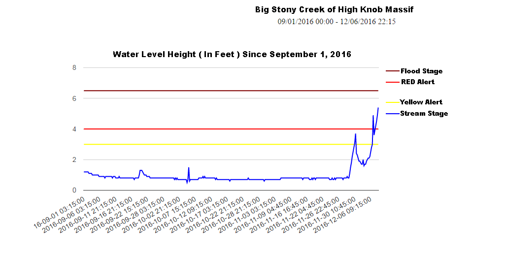
Meanwhile, another heavy rainfall event of up to 2.67″ atop Eagle Knob of the High Knob Massif since Sunday AM has whitewater rolling out of the massif, with the stream gauge on Big Stony Creek peaking at just 13″ below the flood stage. This all has fallen following a literal flat-line ( below ) through Autumn 2016, with little variations on steep creeks.
A general 7.00″ to 8.00″ of total rainfall since November 26 in the massif has generated around 6 vertical feet of water level rise on Big Cherry Lake, and it is still rising.
Big Stony Creek Stream Gauge Since September 1, 2016
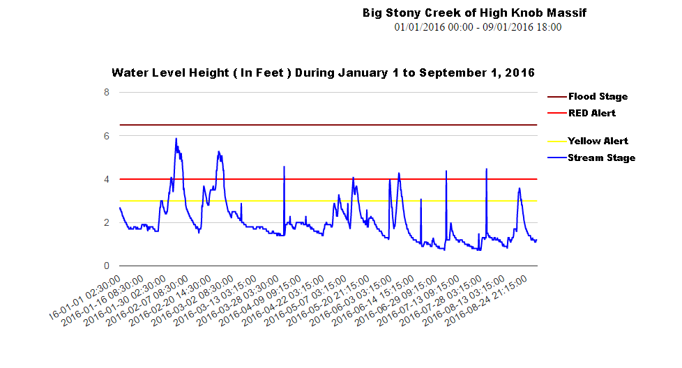
Most of 2016 had abundant precipitation, with many surges in whitewater to ROARING levels during the January 1 to September 1 period ( below ) prior to the flat-lining.
Big Stony Creek Stream Gauge – January 1 to September 1, 2016
The biggest water flows coming with rain + melt down of winter snowpacks early in the year ( during Winter 2015-16 ).
Precipitation for 2016 has now reached into the 60.00″ to 65.00″+ range in upper elevations of the High Knob Massif, from Big Cherry Lake basin into High Knob Lake basin.
Previous Discussion
Another soaking rain Tuesday will give way to a brief shift into upsloping NW-N winds Tuesday Night into Wednesday Morning that will lower clouds bases once again along the windward slopes of the High Knob Massif-Tennessee Valley Divide, with another round of light riming possible at high elevations above 3300 feet.
Majestic Rime In High Knob Meadow – December 3, 2016
Meanwhile, the HRRR Model seems to be doing best at picking up the orographic enhancement along windward slopes of the Cumberland Mountains ( High Knob Landform and the Tennessee Valley Divide ), Cumberland Plateau and Blue Ridge overnight into Tuesday. Rainfall amounts in the favored upslope locations should range in the 1.00″ to 1.50″ category for this event ( potentially heavier, at least locally, pending the influence of upper dynamics ).
HRRR Model Rainfall Forecast Up To 3:00 PM Tuesday – December 6, 2016
The main focus during this forecast period is on a blast of arctic air pouring south from northwestern Canada into the USA, with arrival time here set for Thursday into Friday.
European Ensembles MEAN Sea Level Pressure Anomalies – 7 AM Thursday
This has now been well advertised for some time, especially by the European Ensembles, with a sprawling 1050 MB High Pressure across northwestern Canada. Although relatively short-lived, this will be real deal arctic cold and will mean business for the time in which it grips the Appalachians.
NAM 12 KM Model Total Snowfall Forecast Up To 7 AM Friday
While cold is certain, the amount of snowfall remains in question with the best current thinking being for upper elevations to have the best opportunity for 1″ or more of accumulation. Little to no accumulations are currently expected across lower elevations ( especially below elevations of 1500-2000 feet ).
Partly to mostly clear. Cold. Winds W-NW 5-15 mph, with higher gusts, along mid-upper elevation mountain ridges. Temperatures varying from 10s to low 20s in colder valleys to the upper 20s to lower 30s. Wind chills in the 10s & 20s along higher ridges.
Friday Afternoon
Mostly sunny. Seasonally cold. W-NW winds 5-15 mph with some higher gusts ( especially along ridges ). Temperatures varying from upper 20s to lower 30s in upper elevations to the upper 30s to lower-middle 40s. Wind chills in the 20s and 30s, with 10s in stronger gusts on the highest peaks.
Friday Night Into Saturday Morning
Becoming cloudy. Chance of a few flurries. Low clouds possible into morning with dense fog & riming at highest elevations along-north of the High Knob Massif-Tennessee Valley Divide ( mainly above 3000 feet ). Winds NW-N 5-15 mph along mid-upper elevation mountain ridges. Temps varying from around 20 degrees on highest peaks to the middle 20s to lower 30s. Wind chills in single digits & 10s across upper elevations to the 20s.
Saturday Mid-Morning Into The Afternoon
Morning low clouds giving way to sunshine and high clouds. Light NNW-NNE winds. Temperatures varying from upper 20s to lower 30s in upper elevations to the upper 30s to low 40s ( milder in valleys of the Clinch, Powell, and Holston ).
Saturday Night Into Sunday Morning
Increasing clouds. Mixed precipitation or snow becoming possible into morning. Light winds, except becoming SSE-SW at 5-10 mph on mid-upper elevation ridges. Temps in the 20s to mid 30s ( steady or slowly rising along upper elevation mountain ridges before precipitation onset ).
Sunday Afternoon
Any high elevation snow or mixed precipitation changing to rain. Otherwise, raw and rainy with nasty conditions. Increasing SE-S winds at 5-15 mph, with higher gusts, along mountain ridges-plateaus below 2700 feet. Winds SSE-SSW 10-20 mph, with higher gusts, along upper elevation mountain ridges. Temperatures in the 30s to low-mid 40s. Wind chills in the 20s and 30s along higher ridges.
A chance for development of mixed precipitation, or snow at upper elevations, will be possible Sunday before a change to rain at all elevations by later Sunday into Monday. Some light accumulations, up to 1″ or locally more on the highest peaks, will be possible before a change to rain.
Weather Discussion ( Active Pattern )
Late Saturday Night Update
A nice riming event into Saturday morning capped the high country with super-cooled water deposited upon vegetation and trees, producing growth into the wind.
Majestic Rime Caps The High Knob Massif – December 3, 2016
Rime formation started during evening hours of December 2 and continued into the afternoon of December 3 at highest elevations.
High Knob Massif MesoNET – Eagle Knob At 4188 Feet
The day ( Saturday ) was cold as even valleys in the high country struggled to break freezing, with 34 degrees being reached in the Big Cherry Lake basin by late afternoon.
Regional Doppler Composite At 2:47 AM Sunday – December 4, 2016
Initially dry air is causing evaporation as a large shield of precipitation begins moving into the region. Evaporative cooling is expected to cause a period of snow and/or mixed precipitation into Sunday AM before a change to all rain. Lower-middle elevations are likely to have little to no accumulation, with locations above 3000 to 3500 feet having the best opportunity for some sticking.
This continues the active pattern and marks the start of another period with significant precipitation. A major blast of cold air follows by late week as the polar jet stream slips farther and farther south over time, following the baroclinic zone that is developing southward ( a natural, predictable tendency driven through increasing snow cover to the north as I taught my class weeks ago in our Field Studies course at UVA-Wise ).
Previous Discussion
An active weather pattern continues in wake of a heavy rainfall event. A few preliminary totals included:
Clintwood 1 W: 2.87″ Nora 4 SSE: 2.96″ Coeburn ( In Town ): 3.61″ UVA-Wise NWS: 3.62″ Appalachia ( In Town ): 3.97″ City of Norton WP: 3.98″ Black Mountain Mesonet: 5.00″
Widespread 4.00″ to 5.00″ rain amounts were common from the High Knob Massif to Black Mountain and northern parts of Lee County. A general 3 to 4 vertical feet of rise occurred on steep creeks ( like Big Stony ) draining the high country surrounding High Knob, with similar rises observed so far on water supply lakes in the City of Norton & Big Stone Gap.
High Knob Massif Webcam – University Of Virginia’s College At Wise
Some minor systems will impact the mountain area this weekend with a chance for lowering cloud bases into early Saturday that could generate a flake and/or some riming in upper elevations before giving way to high altitude clouds ahead of the next system.
NAM 12 KM Model Total Precipitation Forecast Up To 7 AM Monday ( Dec 5 )
Another healthy precipitation event is on tap for Monday into Tuesday ( December 5-6 ), with the latest run of the 51-Member European Ensemble group forecasting a MEAN basin average total of 1.00″ to 2.00″ ( again implying, as observed during the last event, some heavier totals ).
With chilly, drier low-level air in place initially by later Saturday into early Sunday the leading edge of developing precipitation could begin as some mixture or snow early on Sunday before changing into all rain at all elevations. At least, that is the current thinking. Stay tuned for updates.
European Ensemble MEAN Sea Level Pressure Anomalies – 7 AM December 7
In the extended, building Arctic High Pressure over northwestern Canada will become a major player in weather conditions across the USA by middle to latter portions of this first full week of December ( above ).
European Ensemble MEAN 850 MB Temperature Anomalies – DAYS 6 to 10
The coldest air will ooze its way down the eastern side of the Rockies before spreading eastward, with modification over mostly snow-free ground. This will turn temperatures well below average by later next week, with the magnitude of the cold yet to be determined ( as is any snowfall ).