An increasing chance of showers & downpours in thunderstorms will be observed Wednesday-Friday ( especially during afternoon-early evening hours ). Some storms may become strong to locally severe, on general principles, but torrential rainfall may end up being the main aspect that will need to be monitored most.
Overnight Into Tuesday Morning
Partly to mostly clear. Areas of fog. Light N-NE winds generally less than 10 mph along mid-upper elevation mountain ridges-plateaus. Temperatures varying from upper 40s to mid 50s in cooler mountain valleys to the upper 50s to lower 60s.
Tuesday Afternoon
Partly to mostly sunny. Warm & humid. Small chance of an isolated shower or thunderstorm. Light NNE to ENE winds at generally less than 10 mph. Temperatures varying from the low-mid 70s in upper elevations to the low-mid 80s.
Tuesday Night Into Wednesday Morning
CAUTION for Dense Fog between Little Stone Mountain Gap, and Powell Valley Overlook, and Big Stone Gap for travelers along U.S. 23 ( and old U.S. 23 heading into Appalachia ).
Partly to mostly clear. Areas of fog ( dense in Powell Valley and locations having heavy rain during Tuesday ). SE-SSW winds generally under 10 mph. Temperatures varying from 50s amid cooler mountain valleys to the low-mid 60s.
Wednesday Afternoon
Partly-mostly cloudy. Chance of showers & thunderstorms. Locally heavy rainfall possible. Light SE-S winds at mostly less than 10 mph ( outside any storms ). Warm & humid with temperatures varying from low-mid 70s at highest elevations to the lower-middle 80s.
Wednesday Night Into Thursday Morning
Chance of evening showers & thunderstorms. Partly to mostly cloudy. Areas of fog. Winds SSE to SSW 5-10 mph, with higher gusts, on mountain ridges-plateaus below 2700 feet. SSW-WSW winds 5-15 mph, with higher gusts, along mountain ridges above 2700 feet. Temperatures varying from the 50s to low-mid 60s.
Thursday Afternoon
Hit-miss showers & thunderstorms. Locally heavy rainfall. Winds SSW-WSW at generally less than 10 mph outside of storms. Temperatures varying from upper 60s to lower 70s in upper elevations to the mid 70s to around 80 degrees.
Thursday Night Into Friday Morning
A chance of showers & thunderstorms. Locally heavy rainfall possible. Areas of dense fog. Winds SSW-WNW at generally less than 10 mph outside of storms. Warm and humid with temperatures widespread in the upper 50s to lower-middle 60s.
Weather Discussion ( May 31-June 2 )
Early Wednesday Update
Local terrain triggered convection erupted in localized fashion during Tuesday, with torrential rainfall along the U.S. 23 corridor between Norton and Big Stone Gap.
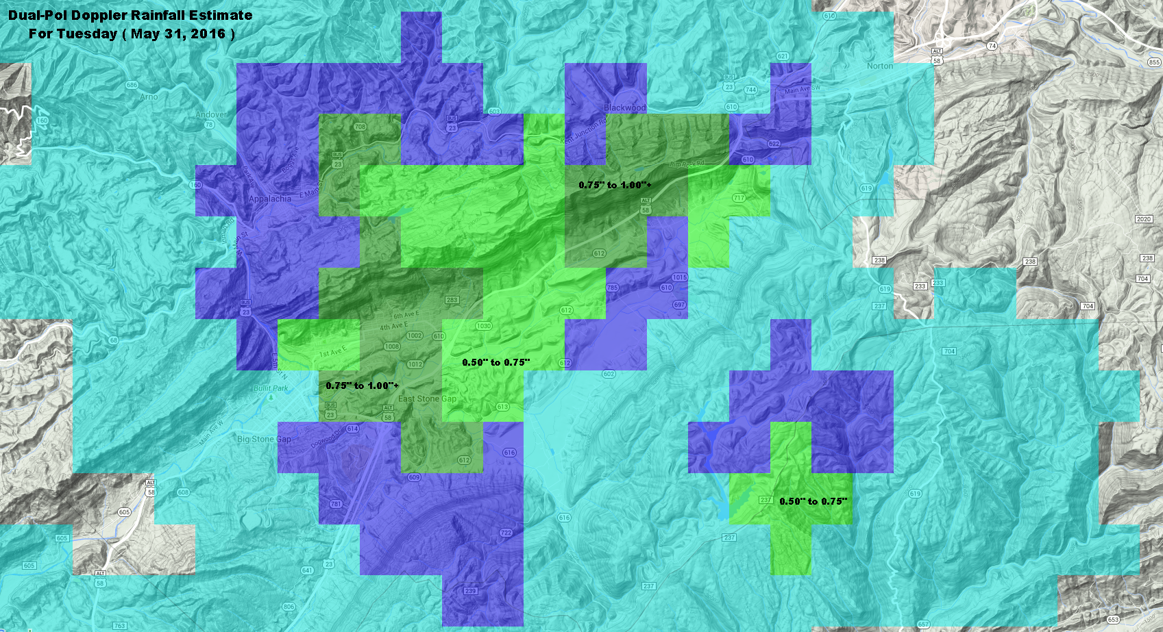
Doppler Rainfall Estimate For Tuesday – May 31, 2016
A general 0.50″ to 1.00″+ of rainfall fell along U.S. 23 from near the Powell Valley Overlook, and Little Stone Mountain Gap, to the East Stone Gap area of Powell Valley. Heavy rain, which initially developed along Powell Mountain, moved across Little Stone Mountain to the Appalachia Lake Water Plant.
An area of rainfall developed earlier in the day ( early PM ) over portions of the Big Cherry Lake, Devil Fork and Straight Fork basins of the High Knob Massif, with 0.52″ of rain reported by a typically low reading automated gauge on Little Mountain. Other locations, by contrast, had little rain.
NAM 12 KM Model Total Rainfall Forecast To 8 AM Saturday – June 4, 2016
The hit-miss action of Tuesday is likely to be replicated on coming days, with heavy rainfall and strong storms hitting daily in different places. Any places that do get hit multiple times will be at higher risk for significant run-off and the possibility of strong water level rises.
GFS Model Total Rainfall Forecast Next 5 Days
Some models, like the GFS, are forecasting heavy rain amounts during the next 5 days. Models; however, are merely guessing at where the heaviest amounts will fall ( with a bias shown toward the major terrain features ). Only time will tell where heaviest total amounts will accumulate through coming days, which will partially ( at least ) be dictated by numerous sources that force convergence ( the coming together of air ) at low-levels.
Previous Discussion
Typical Memorial Day weather conditions were observed across the Mountain Empire, complete with some hit-miss showers & downpours in thunderstorms.
Memorial Day At Browning Family Cemetery – May 30, 2016
In Memory & Honor of all our loved ones lost and our veterans past and present – from the ridge top of Browning Family Cemetery.
Morning temperatures in the low-mid 50s in mountain valleys gave way to a mix of towering cumulus-cumulonimbus into the afternoon as temperatures climbed into the 70s and 80s.
Cumulus Tower Into The Heavens – May 30, 2016
Relatively dry air aloft created beautiful blue skies to set off towering afternoon-early evening cumulus ( tropical skies ).
Early Evening Cumulus Tower In Majestic Light – May 30, 2016
Light hitting a ridge top as the sun drops downward toward the western mountain horizon ( to left of above scene ).
Following a wetter and cooler than average May across much of the mountain area, the upcoming trend through the next 5 to 10 days is back toward a wetter and eventually cooler ( next week ) than average weather pattern for this time of year ( especially amid the mountains ).
European Ensembles 500 MB Height Anomalies Forecast – DAYS 1-5
A reversion back to an eastern USA upper air trough and western USA upper air ridge pattern is forecast to develop into next week.
European Ensembles 500 MB Height Anomalies Forecast – DAYS 6-10
The impact on temperatures can be seen below.
European Ensembles 850 MB Temp Anomalies Forecast – DAYS 1-5
Conditions go from above average during the first 5 days of this forecast period ( MEAN during May 31-June 4 ) to below average during the June 5-9 period ( MEAN ).
European Ensembles 850 MB Temp Anomalies Forecast – DAYS 6-10
The beginning of this pattern flip will dominate the short-term and be marked by an increasing chance for showers and downpours in thunderstorms during Wednesday into Thursday as the first cold front and upper air disturbance approaches the Appalachians.
NAM 12 KM Model Total Rainfall Forecast Up To 8 AM Friday – June 3, 2016
It is likely that some storms could become strong to locally severe given parameters being forecast by the high resolution NAM Model group for Wednesday afternoon and especially Thursday PM-early evening. Please stay tuned for updates.
This initial boundary will have a difficult time clearing the Mountain Empire as upper air troughing begins to develop and becomes reinforced by additional upstream fronts and disturbances into next week ( likely creating a stormy and unsettled period of weather that trends cool for this time of year over time ). Speaking of which, at this time of year any boundary that stalls must be closely watched given copious amounts of moisture available for showers & downpours in thunderstorms ( typically featuring widely varied rainfall amounts across the mountain landscape ).