Partly to mostly cloudy. Cooler. WNW to NW winds decreasing to less than 10 mph along middle elevation ridges below 2700 feet. WNW-NW winds 5-15 mph, with higher gusts, along upper elevation mountain ridges. Temperatures varying from middle to upper 40s to the middle-upper 50s.
Wednesday Afternoon
Partly-mostly sunny. Blue skies. Unseasonably cool for the season with NW-NNW winds at 5-10 mph ( higher gusts on mid-upper elevation ridges ). Temperatures varying from 50s at highest elevations to the middle 60s to lower 70s.
Wednesday Night Into Thursday Morning
Mostly clear and unseasonably cold. Light winds along middle elevation ridges-plateaus. NNW-N winds 5-10 mph on upper elevation mountain ridges. Temperatures varying from upper 30s to lower 40s in coldest valleys of mid-upper elevations to the middle 40s to lower 50s. Areas of fog possible, especially along major river valleys & lakes.
Thursday Afternoon
Mostly sunny. Light W-NW winds. Temperatures varying from 60s across upper elevations to the 70s in middle to lower elevations ( warmer south toward the Tri-Cities ).
Thursday Night Into Friday Morning
Becoming partly to mostly cloudy. W to NW winds 5-15 mph along mid-upper elevation mountain ridges. Temperatures varying in the 40s and 50s ( coolest in mountain valleys ).
Weather Discussion ( June 7-10 )
A refreshing air mass overspread the mountain area during Tuesday ( June 7 ), with much lower dewpoints ( humidity ) and beautiful blue skies. An early summer treat!
Refreshing June Air Mass – American Beech & Yellow Poplar – June 7, 2016
Afternoon MAXS varied from 60s in upper elevations to the lower-middle 70s within middle elevations ( between 2000-3000 feet ) to the upper 70s to around 80 degrees in lower elevations.
Remember I break my forecast’s down by elevation zones:
Lower Elevations Below 2000 Feet
Middle Elevations 2000-3000 Feet
Upper Elevations Above 3000 Feet
*With respect to boundary layer conditions I often divide middle and upper elevations at the 2700 foot level. This allows for the upward bulge generated amid the atmosphere by the High Knob Massif where many valley floors rest at or above 2700 feet.
The boundary layer refers to that portion of the lower atmosphere which is in contact with the Earth’s surface. It is often defined as the friction layer, or that part which is most influenced by terrain generated drag.
The boundary layer tends to expand during the day with thermal heating and contract by night with cooling. In complex terrain, such as that within the High Knob Massif area, multiple inversion layers develop at different levels on any given night if decoupling ( detachment ) occurs ( i.e., winds decrease and become detached in valleys from more organized winds amid the boundary layer, or blowing along its top, and are replaced by cold air drainage flows and associated circulations ).
Nora 4 SSE – NWS Station In The Middle Elevations
The official NWS MAX in Clintwood reached 79 degrees on June 7, with a temperature drop to 56 degrees observed by Midnight.
While there will be plenty of dew forming on roses and other flowers in coming nights, it will come very close to turning frosty amid coldest valleys of middle to upper elevation within the High Knob Massif-Burkes Garden corridor into morning hours of Thursday ( June 9 ).
Red Rambling Rose ( Rosa spp. ) Escaped Into The Wild – June 2016
Mean dewpoints in the 30s within the 900 to 850 MB zone will be able to generate significant cold air drainage, amid light winds and mostly clear skies, with valleys above 2000 to 3000 feet becoming coldest during Wednesday Night into Thursday AM.
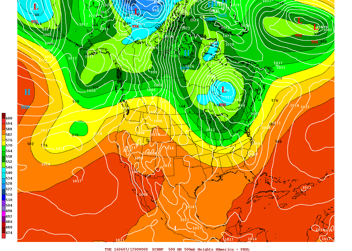
European Model 850 MB & Surface Analysis At 8 AM Tuesday – June 7, 2016
The current autumn-winter like upper air pattern will change radically into this weekend and next week, at least for much of the nation outside of New England where a chilly pattern looks to hold on beneath upper troughing.
European 51-Member Ensemble 500 MB Height Anomalies MEAN: Days 1-5
A pattern like this in June typically signals a battle zone with showers & thunderstorms moving around the peri-phery of hottest air. Exactly where this sets up into the weekend and next week will dictate how wet ( or not ) it becomes within the Mountain Empire.
European 51-Member Ensemble 500 MB Height Anomalies MEAN: Days 6-10
Meanwhile, be sure to enjoy a few gorgeous days of awesome June conditions in the southern Appalachians!