My Forecast For Today ( January 20 )
ALERT For The Development Of Accumulating Snow And Hazardous Travel & Walking Conditions
*Due to prolonged bitter temperatures hazardous driving and walking conditions will quickly develop across the region today. Extreme Caution Is Advised.
It would be best for county schools to close today before getting any buses on roadways ( recommended, with each county having to make their own decision ).
Specific Snowfall Forecast
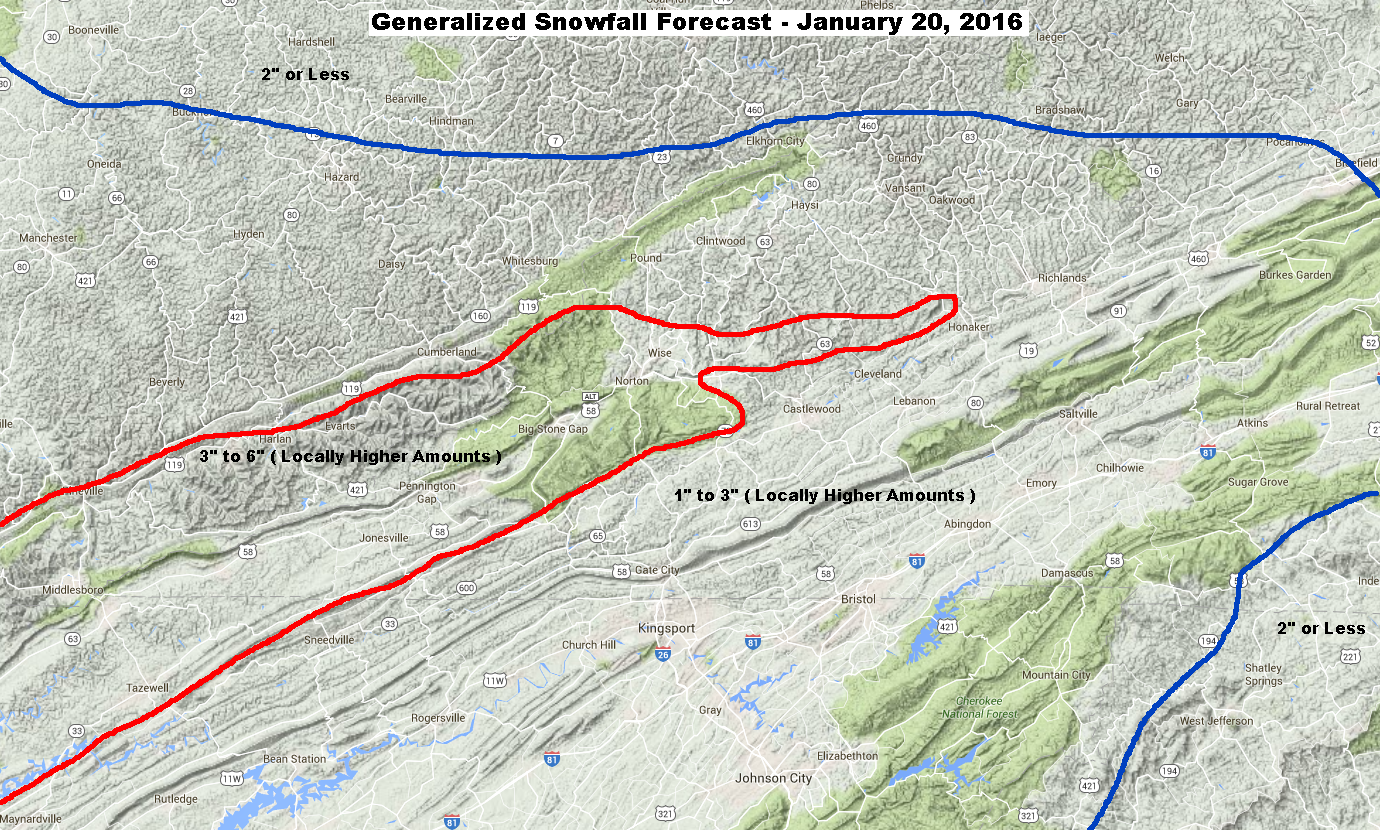
2″ to 4″ Russell Fork Basin
( Pound – Clintwood – Haysi )
3″ to 6″ Upper Tennessee Basin
( Norton – Wise – Big Stone Gap )
4″ to 8″ Above 3000 Feet
( High Knob Massif )
Target Snowfall of 4″ In Norton-Wise ( +/- ) 1″ Error Potential. This implies a chance for 3″ to 5″ of snow accumulation.
A general depth of 4″ or more is expected to develop above 3000 feet elevation in the High Knob Massif, with a target snowfall of 6″ at 3500 feet ( +/- ) 2″ Error Potential. This implies the chance for 4-8″ of snow depth above 3000 feet in the High Knob Massif.
Potential Of A Major Winter Storm Is Increasing For The January 22-24 Period. This Could Be A Crippling Winter Storm Event And Will Need To Be Closely Followed During The Next 24-48 Hours.
Overnight Into This Morning
Increasing clouds. Light snow developing. Light & variable winds becoming S to SSW at less than 10 mph on mountain ridges & plateaus below 2700 feet. Winds becoming SSW to WSW at 10-20 mph, with higher gusts, along mountain ridges above 2700 feet. Wind chills in the single digits, except locally below zero on highest mountain ridges.
Temperatures in the single digits ( mountain valleys ) to mid 10s ( mountain ridges and plateaus ) will tend to rise into the predawn-morning.
Mid-Morning Through This Afternoon
Snow. Becoming moderate to heavy into the afternoon. SSW-W winds of 5-15 mph below 2700 feet. Winds SW-WNW at 10-20 mph, with higher gusts, above 2700 feet. Temperatures mostly in the 20s ( lower 30s possible IF mixing can develop into lower elevations ).
Tonight Into Thursday Morning
Snow to snow showers & flurries before ending. Low clouds. W winds at 5 to 15 mph shifting N to NNE into morning and decreasing to 10 mph or less ( possible cloud base drop into middle elevations ). Temperatures varying from the 10s at highest elevations to the 20s.
*Lingering low-level moisture could allow cloud bases to drop into the middle elevations, with a freezing fog potential, for a period of time during the predawn-morning hours of Thursday on upsloping northerly air flow ( generally from the elevation of Wise upward ) for locations along & north of the High Knob Massif and Tennessee Valley Divide ( e.g., Black-Hazel-Big A mountains ).
Weather Discussion ( January 19-20 )
Another bitter day was observed during January 19 with afternoon MAX temperatures varying from 10 degrees at the summit level of the High Knob Massif to 18 degrees within the deep mountain hollow at Clintwood 1 W.

Before clearing skies into afternoon a low cloud deck generated light snow within the upslope corridor from the High Knob Massif north across Norton-Wise to Pound-Clintwood ( on NW winds ).
**Date-Time-Wind-Vis SKY Cloud Temp-DP Humidity WCF B.P.

Light snow accumulations of from 0.1″ to 0.3″ were common during the 6-hour or so period with falling flakes as a little upslope combined with a bit of moisture from Lake Michigan.

Temperatures fell off into single digits amid mountain valleys during evening hours of January 19, beneath clear skies, to contrast with near steady or slowly rising temps across exposed mid-upper elevation mountain ridges.

Focus now shifts to a disturbance ( lead wave ahead of the MAIN EVENT ) across the Mississippi Valley that will be moving into this mass of Arctic air.
This wave will be dampening over time, thus its influence will be least along the eastern side of the Appalachians and greatest along the western side of the mountain chain.
Precipitation today will be driven by warm air advection and isentropic lifting, with a period of SW air flow up the High Knob Landform corridor expected to enhance snow amounts above the generalized 1-3″ that is expected across the region ( higher end totals likely being realized in this case amid the region in general since past climatology well dictates that it takes a while for snow densities to rise up toward 10:1; therefore, model QPF will be able to generate more snow than strict 10:1 ratios ).
**So two aspects may need to be tweaked today. Snowfall amounts, which I have already done in an upward manner, as well as temperatures with a very cold start to the day being covered by clouds in combination with onset of strong evaporative cooling.
The battle between warm air advection and evaporative cooling ultimately acting to dictate temperatures today. If evaporation generates an inversion then gusty winds aloft will tend to flow over the top and temperatures at lower-middle elevations will tend to be colder than if vertical mixing occurs ( which then can work to warm lower-levels, especially those under downslope ).

The NAM Model is very close to the European on total precipitation amounts ( both models generating snowfall totals using a 10:1 ratio ); therefore, it is likely that if these models are correct that snow amounts will be somewhat higher than they suggest given past climatology of WAA and moisture transport into true arctic air masses.
WAA = Warm Air Advection
If the models are over-estimating precipitation amounts, then snow totals could end up being close to what they show or even lower than they are predicting. One reason that I always have a ERROR Potential factored into my snowfall forecast’s.
No forecast model is absolutely correct ( one has to adjust as past climatology dictates, then choose the least “wrong” solution )!

The system today, regardless of final snow amounts, is going to cause widespread hazardous travel across the Mountain Empire and will catch many off-guard if not expecting this. WHY would you not, given days of bitter temperatures have everything frozen.
Major Winter Storm Upcoming
Although the event today will no doubt cause its share of travel troubles, especially in the Tri-Cities area of NE TN, and the Great Valley in general, where significant falls of snow are MUCH less common than here in the mountains, it will be nothing compared to what may be ahead if model trends during recent days are correct.
