Mountain Area Forecast ( August 22-25 )
Caution For Swift Water On Steep Creeks Draining The High Knob Massif Into Monday
Sunday Night Into Monday
Mostly clear. Cooler & refreshing. Areas of dense valley fog. Winds WNW-NNW 5-15 mph, with higher gusts, along mid-upper elevation mountain ridges. Temperatures in the 50s to near 60 degrees ( 50-55 degrees in cooler locations ).
Monday Afternoon
Partly sunny. Beautiful skies & pleasant. Winds NW-N at generally less than 10 mph. Temperatures varying from 60s in upper elevations to the mid-upper 70s.
Monday Night Into Tuesday Morning
Clear & cool. Areas of dense valley fog. Light winds, except winds becoming E-SSE at 5-10 mph along the highest ridges. Temperatures varying from 40s in cooler mountain valleys of mid-upper elevations with limited fog to the mid-upper 50s on exposed middle-upper elevation ridges.
Tuesday Afternoon
Partly-mostly sunny. Warmer. Light SE-S winds. Temperatures varying from upper 60s to lower 70s at highest elevations to the upper 70s to lower 80s.
Tuesday Night Into Wednesday Morning
Partly cloudy. Areas of dense valley fog. Winds S to SSW at 5-10 mph, with some higher gusts, on mid-upper elevation mountain ridges. Temperatures varying from the 50s to low-mid 60s ( coolest in mountain valleys ).
Wednesday Afternoon
Partly cloudy. Hazier. A chance of hit-miss showers & thunderstorms. Winds SSW-SW 5-10 mph, with higher gusts. Temperatures varying from lower 70s at highest elevations to the upper 70s to low-mid 80s.
Wednesday Night Into Thursday Morning
Partly cloudy. Chance of an evening shower or storm. Areas of dense valley fog. Winds SSW-W at 5-10 mph, with higher gusts, along mid-upper elevation mountain ridges. Temperatures in the upper 50s to mid-upper 60s.
Weather Discussion ( Brief Break )
( Cumulus congestus ) and other forms along an orographic wave line

Except for lingering orographic clouds, a push of much drier air finally made it into the Cumberland Mountains during mid-late afternoon hours of Sunday ( Aug 21 ).
Day-time MAXS varied in the 60s to lower 70s ( 72.8 degrees officially in Clintwood ).
( Cumulus radiatus )
( Stratocumulus lenticularis duplicatus )
( Altocumulus lenticularis duplicatus )
( Cirrus uncinus )

Rainfall was enough to force strong rises on steep creeks draining the High Knob Massif, which will remain swift into Monday before diminishing.
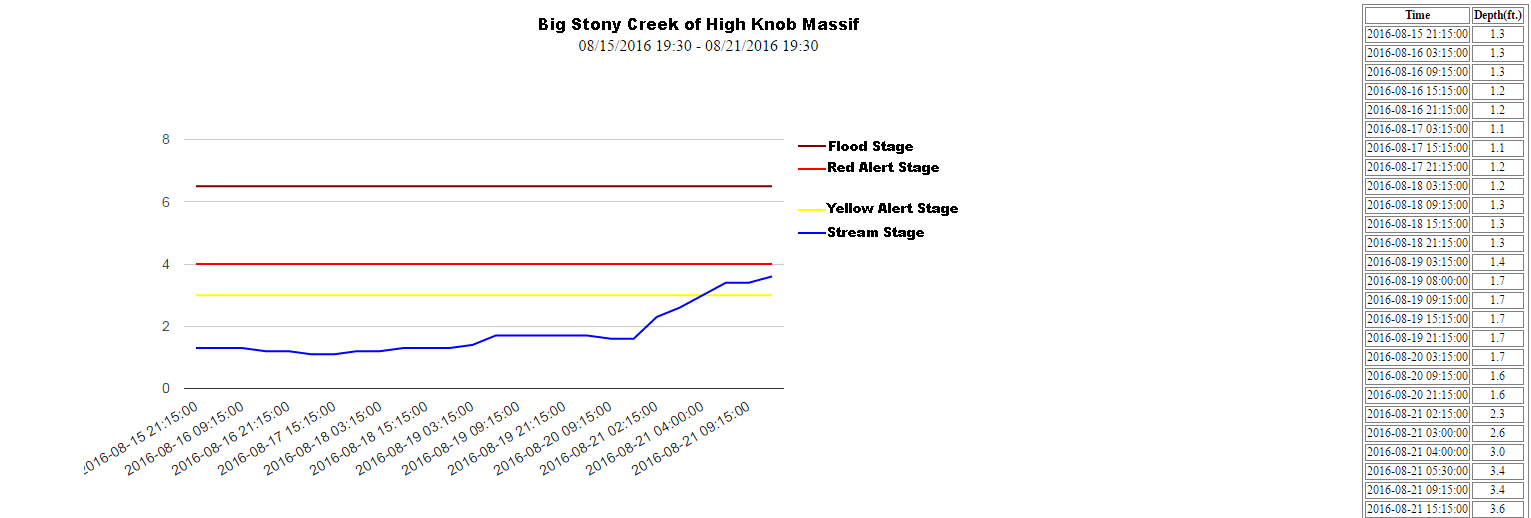
A water level rise to near the Red Alert Stage on Big Stony Creek is a good indicator for other steep creeks draining the high country, where this event has pushed 2016 precipitation totals into the 45.00″ to 50.00″ range ( 18.00-20.00″+ during Summer 2016 ).
