Partly-mostly cloudy. Chance of a hit-miss shower or storm. Winds SSE-SSW 5-10 mph, with higher gusts, on mountain ridges-plateaus below 2700 feet. Winds S-SW at 10-20 mph, with higher gusts, on mountain ridges above 2700 feet. Temperatures varying from upper 50s to lower 60s in cooler valleys, with areas of fog, to mid-upper 60s.
Saturday Afternoon
Partly to mostly cloudy. Chance of scattered showers & thunderstorms. Winds SSW-SW 5-15 mph, with higher gusts, on mid-upper elevation mountain ridges-plateaus. Temperatures varying from lower 70s in upper elevations to the upper 70s to lower 80s ( hotter south into the Great Valley of eastern Tennessee and southwest Virginia ).
Saturday Night Into Sunday Morning
Mostly cloudy. Chance of a shower or thunderstorm. Winds SSW-WSW 5-15 mph mid-upper elevation mountain ridges. Temperatures widespread in the 60s.
Sunday Afternoon
Showers & downpours in thunderstorms likely. Locally heavy rainfall amounts. Winds becoming W-NW at 5-10 mph, with higher gusts. Temperatures varying from the lower 60s in upper elevations to upper 60s to lower 70s. Low clouds and fog along higher mountain ridges. Patchy fog possible in other locations.
Sunday Night Into Monday
Showers & thunderstorms giving way to showers. Locally heavy rain possible into the overnight. Areas of fog ( dense along higher mountain ridges ). Winds becoming WNW-N at 5-10 mph, with higher gusts, along mid to upper elevation mountain ridges. Temperatures varying from mid-upper 50s to the low-mid 60s ( coolest in upper elevations ).
Following a dry first-half to September it appears that a cold frontal boundary will finally bring some significant rainfall to the mountain area this weekend.
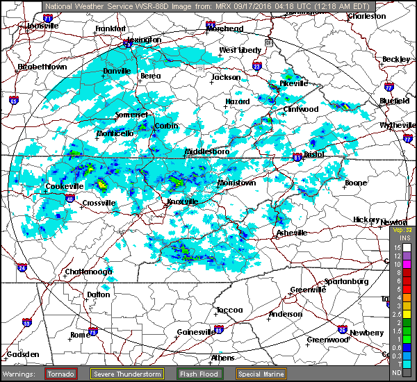
Doppler Rainfall Estimate For Friday – September 16
Local hit-miss downpours developed Friday ( above ), with more of the same possible Saturday before activity increases Sunday.
NAM 12 KM Model Total Rainfall Forecast To 2:00 PM Sunday – September 18
The main focus of heavier rains will be on Sunday for locales along and west of the Cumberland Mountains ( shifting east toward the Great Valley by late in the day ). Exact timing, of course, subject to change as activity actually develops.
NAM 12 KM Model Total Rainfall Forecast To 8:00 PM Sunday – September 18
If activity develops early along the Cumberland range the day will feature much lower temperatures and low clouds, with some orographic lifting across the high terrain.
European 51-Member Ensemble MEAN 500 MB Height Anomalies – DAYS 4 to 8
While much lower dewpoint air will again create some nice, cool nights during early-middle portions of next week, the current trend is for a rebuilding of 500 MB heights across the southeastern USA during September 20-24.
European 51-Member Ensemble MEAN 850 MB Temp Anomalies – DAYS 4 to 8
Daytime temperatures will again surge above average, with at least the potential for some more 90 degree days in the Great Valley ( especially if total rainfall is not heavy ).
Track Forecast For Typhoon Malakas
However, current extended trends suggest that heat next week will give way to MUCH cooler air and the first true shot of Canadian Chill during the final days of this month as a recurving typhoon in the western Pacific links up with the Polar Jetstream to force downstream changes in the flow pattern across North America. Stay tuned!