ALERT For Accumulating Snow Tonight Into Thursday Morning With Bitterly Cold Temperatures-Wind Chills During Tuesday Into Thursday. This Pattern Is Likely To Continue Through This Weekend Into Next Week To Mark A Harsh Period Of Winter In The Appalachians.
Snow covered & hazardous road conditions will continue and worsen overnight into Tuesday morning as temps drop. Travel is not recommended unless absolutely necessary. Please use extreme caution if traveling overnight.
Overnight Into Tuesday Morning
Light snow, snow showers & bursts of heavy snow. Turning bitter into morning. W-WNW winds 5-15 mph, with higher gusts, at elevations below 2700 feet. Winds W-NW 10-20 mph, with higher gusts, upper elevation mountain ridges. Blowing & drifting snow at high elevations. Temperatures dropping into low 10s at highest elevations and into upper 10s to lower-middle 20s at lower-middle elevations ( near 10 degrees at the summit of High Knob Massif ). Wind chills dropping into single digits & 10s, except 0 to -15 below zero across upper elevations in the High Knob Massif & Black Mountain. Extensive rime formation at high elevations.
This Afternoon
Light snow & snow showers. Local bursts of heavier snow. Cold. Winds W to NW at 5-15 mph, with higher gusts, along middle-upper elevation mountain ridges-plateaus ( blowing & drifting snow at exposed middle-high elevations, riming at high elevations ). Temperatures varying from 10s above 3000 feet to lower-middle 20s ( milder in the Clinch, Powell, Holston river valleys toward the Tri-Cities ). Wind chills in the single digits and 10s, with sub-zero values in gusts along high mountain crestlines.
Tonight Into Wednesday Morning
Snow & snow showers. Local bursts of heavier snow. Bitter. Winds W to NW at 5-15 mph, with higher gusts, along mid-upper elevation mountain ridges & plateaus. Blowing and drifting snow with riming at high elevations. Temps from single digits at highest elevations to the 10s in Norton-Wise ( milder in lower elevations toward the Tri-Cities ). Wind chills in single digits above & below zero ( coldest at high elevations, with WCF’s as low as -10 to -15 below zero ).
New Snowfall – Tonight Thru Wednesday
A general 4″ to 8″+ along upslope side of mountains
( Target storm snowfall total of 8″ in Norton-Wise )
1″ to 4″ on downslope side of mountains
Target storm snowfall total ( for entire event ) remains at 8″ for Norton-Wise ( +/- ) 2″ to imply a potential for 6″ to 10″ . A general 2″ to 3″ had accumulated up to Midnight on Feb 8 in Norton-Wise.
Target storm snowfall total ( for entire event ) is 8″ to 14″+ for upper elevations in the High Knob Massif. A general 5″ to 6″ had fallen up to Midnight on February 8 at elevations above 3200 ft.
Snow depths at any given time, outside of drifting, are expected to be less than total snowfall by 1-3″ due to melting-sublimation and settlement over time during this prolonged event.
Storm total extremes are expected to vary from more than 12″ amid highest elevations in the High Knob Massif to 3″ or less in portions of the Tennessee Valley ( downslope of mountains ).
This snowfall will occur over a prolonged period of time and generally be of low to very low density ( fluffy ). This tends to enhance settlement over time as snow depth increases. Note storm snowfall totals are between Monday AM and Thursday AM ( i.e., snowfall totals by Thursday Morning are currently projected to reach forecast storm total values ).
A prolonged rime event is expected for upper elevations, above 3300 feet, in the sprawling High Knob Massif where significant accumulations are likely during the next few days.
Weather Discussion ( February 8-9 )
My Afternoon Update
As of 9:00 AM, Superintendent Andrew Greear and Caleb Ramsey reported that total snowfall had reached 5.6″ at the City of Norton Water Plant ( 1.5″ of new snow accumulated during the 4:00 to 9:00 AM period ).
The official 8″-diameter National Weather Service rain gauge total reached 0.37″ for the water content on 5.6″ of snow, making for a 15:1 density ( snow to water ratio ) at the City of Norton WP.
3:00 PM Update: Caleb Ramsey reported only 0.7″ of new snow at the Norton Water Plant at 3 PM. This makes an event total of 6.3″ ( 6″ currently on the ground ).
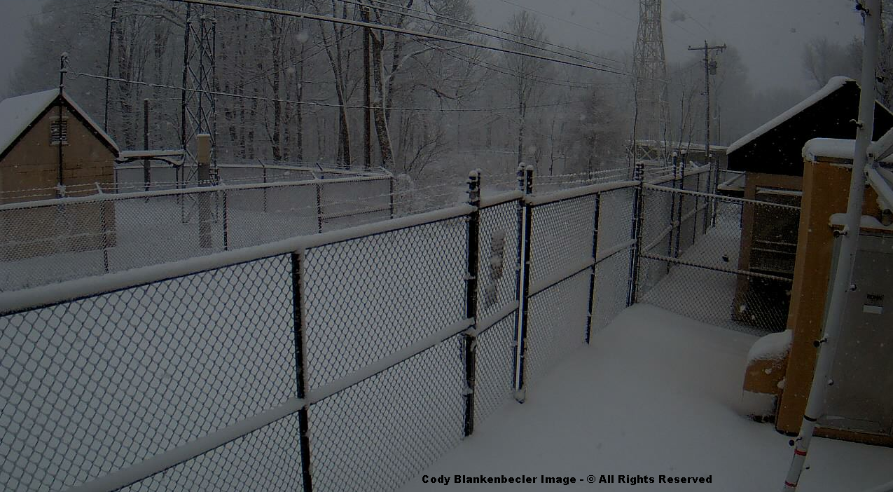
Cody Blankenbecler reported 4″ of snow depth on East Park Avenue in downtown Norton, where some snow has melted, of course, along the pavement ( just after 4:30 PM ).
High above, on Eagle Knob of the High Knob Massif, around 2.0″ of new snow has accumulated to bring the storm tally to 13.0″ ( with moderate-heavy snow during the past hour ).
Deep Snow In High Chaparral of High Knob Massif at 4:00 PM on February 9, 2016
Joe & Darlene Fields confirm the new snowfall with 2.0″ of new snow reported in High Chaparral, to bring the storm tally to 10.2″ at their home ( elevation 3300 feet ) at 4 PM.
High Knob Massif Webcam – University Of Virginia’s College At Wise
There have been some significant snow depth variations around Wise due to ground temperatures and wind in combination with this low density snow ( note I had anticipated that and have had it in my forecast during the past couple of days ). The most snow being held on colder, north slopes and more sheltered locations.
At 9:30 AM, Joe & Darlene Fields reported a snowfall total of 8.2″ in High Chaparral of the High Knob Massif ( including 1″ which fell and melted during the day yesterday ).
Eagle Knob of High Knob Massif at 2:35 PM – February 9, 2016
The air temp on Eagle Knob has been hovering around 9 degrees this afternoon, with wind chill factors as low as -10 below zero at times in gusts on NW winds. Snow is falling steadily and cloud bases have temporarily lifted off the summit to reveal extensive riming of trees.
At around the same time ( 9-10 AM ), the snowfall total on Eagle Knob of the High Knob Massif reached approximately 11.0″, with more than a foot of snow depth in many places.
By rather dramatic contrast, Chris Allgyer measured only 0.5″ on his deck in Big Stone Gap at 9:00 AM this morning.
Likewise, lee of the massif, in The Pines area of the Clinch River Valley near Dungannon, Anna Hess reported only 0.8″ of snow depth this morning.
To the north, here in Clintwood, I’d had 3.0″ of snowfall with a mean depth of 2″ on the ground.
My Overnight Discussion
As of Midnight, and the beginning of another day, snow depth reports varied from 1-2″ in Clintwood to around 3″ across Norton-Wise and 5″ to 6″+ amid upper elevations of the High Knob Massif ( above 3000 feet ).
4:00 AM Update: Scott Craft measured 1.9″ of new snow at the City of Norton Water Plant ( fell during 10 PM to 4 AM period ). This makes a storm snowfall total of 4.1″ and a depth of 4″ at the northern base of the High Knob Massif.
Scott Craft measured 2.2″ up to 10:00 PM on February 8.
Simply gorgeous scenes were captured around sunset.
High Knob Massif Webcam – University Of Virginia’s College At WiseHigh Knob Massif Webcam – University Of Virginia’s College At WiseHigh Knob Massif Webcam – University Of Virginia’s College At Wise
The evening featured continuous snow with intervals of moderate to heavy snow. Darlene Fields shows large flakes falling furiously in High Chaparral around 9:30 PM.
Snow Falling In High Chaparral of High Knob Massif at 9:28 PM ( Feb 8 )
Roads in Wise became covered by around 11:00 PM.
High Knob Massif Webcam – University Of Virginia’s College At Wise
Temperatures have been dropping with 10s across highest elevations ( wind chills around 0 degrees in gusts ).
Black Mountain MesoNET Up To 1:15 AM – February 9 ( Elevation 4031 feet )
There was some interest in thundersnow Monday. When I was outside taking these photographs I heard a rumble that certainly sounded like thunder ( falling snow muffles sound waves and unless the thundersnow is close by it is difficult to hear from a distance ). I have documented thundersnow many times in the High Knob Massif area.
Convective Snow Burst In Clintwood at 2:56 PM – February 8, 2016
There are several different ways, of course, to photograph snow falling. One can set the shutter speed slow and have it silk out into streaks or set it fast to stop motion. You can also set it intermediately, as I did above, for a little of both affects.
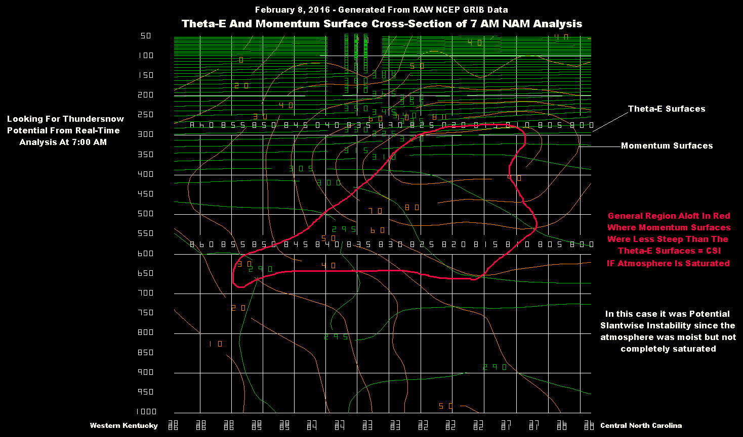
Theta-E & Momentum Surface Cross-Section At 7 AM – February 8, 2016
The above cross-section is taken along a line through the High Knob Massif area, from near the Ohio River in western Kentucky into central portions of North Carolina ( eastward of the Appalachians ). Ideally, these cross sections should be taken perpendicular to the Thermal Wind in the mid troposphere, which I did approximately here since the 700-500 MB flow field was SW in nature early this morning ( the cross-section WNW-ESE ).
I have to first give credit to the late Dr. James T. Moore of Saint Louis University for teaching me about thundersnow following a major local event during March 1995 ( up to 15″ of snow depth accumulated atop the High Knob Massif in a prolonged thundersnow event that lasted for hours ).
Dr. Moore was the king of Isentropic Analysis and a very kind man. He was a true teacher and contributed greatly to the advance of meteorological science.
The March 8, 1995 setting was much different from today but the principles are the same. Conditional Symmetric Instability ( CSI ) is what one is looking for as during most thundersnow events clouds are not vertical. The air mass may, in fact, be stable with respect to vertical ascent but is unstable with respect to slantwise motion. Cloud tops may be less than 20,000 vertical feet tall but the convection can reach up to 40,000+ feet in a tilted or slantwise direction.
Such slantwise convective requires the slope of Momentum Surfaces ( which I have plotted above in brown ) to be more shallow ( less steep ) than the slope of Equivalent Potential Temperature ( called Theta-E ) Surfaces ( which I have in a green color above for the 7 AM Analysis on February 8 ).
The atmospheric state this morning featured a relatively large region with Potential Symmetric Instability since the air mass was not saturated within the layers in which I have roughly outlined ( in red ) where the requirements for CSI were present. With forced lifting to saturation this state could have been converted into CSI, and ended up being in places with good lifting during the afternoon. CSI is strictly defined only in a saturated environment with a lapse rate that is nearly moist-adiabatic in nature.
Approximately in the middle of the cross-section is an area where Theta-E decreases with height to indicate convective instability. CSI & Convective Instability can co-exist, but the upright convection will typically dominate.
Focus during this 36-hour forecast cycle by short-range models are wanting to place the emphasis for heaviest snow across southern Ohio.
NAM 4 KM Model Total Snowfall Forecast To 7 AM Wednesday – 7 PM Run
With abundant 700 MB moisture, cyclonic flow, and cold air advection into the mountains on W-NW flow it is difficult to not accumulate snow, at least at middle-upper elevations.
*Any time air is this cold aloft a RH of 70% or greater at 700 MB is significant, especially amid cyclonic flow. It will be surprising if the upcoming day is void of snow showers and local squalls along the mountains.
NAM 4 KM Model Total Snowfall Forecast To 7 AM Wednesday – 1 AM Run
All models have already greatly under-estimated snowfall in the High Knob Massif & Norton-Wise area up to this point in time, and are very likely also under-estimating snowfall through Wednesday. So for now, I have kept my original snow forecast numbers ( which are to Thursday AM ), and can update later today or tonight if needed.
While many always are interested in snow, the real deal upcoming is bitter cold that will intensify today into Wednesday ( temperatures during the daylight hours of Wednesday will struggle in the 10s in Wise and Norton ). Longer days will help some, but this air mass and the next one upcoming by this weekend are of true arctic origin. The actual Polar Vortex will be stretched enough to push the most bitter air of the entire winter season into the area by late Friday into Saturday ( followed by a potentially heavy snow ).