There Is An Increasing Risk For Frost In Mountain Valleys In Coming Days, Especially By Sunday Night Into Monday AM – Please Stay Tuned For Updates
Temperatures will drop to around freezing at highest elevations in the High Knob Massif during Saturday Night Into Sunday Morning. An abundance of upslope clouds, on WNW flow, will limit the frost potential during this time. However, drier air and low dewpoints will combine with light winds beneath High Pressure to generate strong radiational cooling and cold air drainage into mountain valleys during Sunday Night into Monday Morning.
There will be potential for high clouds into Monday AM, but they may not be thick enough to prevent temperatures from falling to around or below freezing in colder mountain valleys ( MINS are currently expected to drop into the 20s to low-mid 30s in valleys, with coldest conditions in mid-upper elevation valleys at 2000 to 3000+ feet above sea level within the High Knob Massif to Burkes Garden corridor of southwestern Virginia ).
A heavy frost-freeze potential will be possible in and around such communities as Norton-Ramsey, Tacoma-Coeburn, Tazewell and Burkes Garden ( to note a few places ).
I will issue a new forecast late Saturday to cover this potential.
Previous Alerts & Statements
ALERT For High Stream Levels And Ponding Of Water In Poor Drainage & Low Lying Areas Of Northern Wise and Dickenson Counties Into Thursday Evening
*A rainfall total of 1.85″ has been officially measured in Clintwood since Midnight, with 1.45″ since Noon Thursday. Poor drainage and street flooding has occurred, with high stream levels in the area. Caution Is Advised.
The RLX NWSFO has included Dickenson & Buchanan counties in a Flash Flood Watch Until 8:00 AM Friday
The Storm Prediction Center Maintains A Marginal Risk For Severe Thunderstorms Through Thursday Night – Stay Tuned To NOAA Weather Radio And Severe Weather Alert Systems For Any Possible Watches Or Warnings Which May Be Needed
Overnight Into Thursday Morning
Showers & thunderstorms developing. Downpours likely. Winds SW-WSW 5-15 mph along mountain ridges-plateaus below 2700 feet. WSW to WNW winds 5-15 mph, with higher gusts, along mountain ridges above 2700 feet. Temperatures in the 50s to low-mid 60s.
Thursday Afternoon
A chance of hit-miss showers & thunderstorms. Warm and humid. S-SW winds 5-15 mph, with higher gusts, outside of any local storms. Temperatures varying from upper 60s to lower 70s in upper elevations to the upper 70s to lower 80s ( warmest at lower elevations in the Russell Fork and Levisa Fork basins ).
Thursday Night Into Friday Morning
Showers & thunderstorms becoming likely. Some storms could be strong to locally severe. Heavy rainfall possible. SW to WNW winds 10-20 mph, with higher gusts, along middle to upper elevation mountain ridges and plateaus. Temperatures dropping into the 50s to around 60 degrees ( around 50 degrees at highest elevations ).
Friday Afternoon
Becoming partly to mostly sunny. Cooler & less humid. WNW winds 5-15 mph, with higher gusts. Temperatures varying from 50s in upper elevations to the upper 60s to middle 70s ( warmest in lower elevations ).
Friday Night Into Saturday Morning
Partly to mostly clear in the evening. Increasing clouds overnight into morning. Winds becoming SW at 5-10 mph, with higher gusts, along middle elevation mountain ridges and plateaus below 2700 feet. W-SW winds 10-20 mph, with higher gusts, on mountain ridges above 2700 feet. Temps in the upper 30s to mid 40s within colder valleys to the middle to upper 40s across exposed ridges and plateaus.
Saturday Afternoon
A chance of showers. Thunder possible. Windy. SW winds shifting WNW at 10-20 mph, with higher gusts ( especially along mountain ridges ). Turning colder. Temperatures in the 50s to lower-middle 60s, then dropping through the 40s and 50s ( coldest in upper elevations ) during mid-late afternoon, amid blustery conditions.
Saturday Night Into Sunday Morning
Partly to mostly cloudy. Cold. Gusty WNW-NW evening winds decreasing to less than 10 mph overnight along middle elevation ridges-plateaus below 2700 feet. WNW to NW winds 10-20 mph, with higher gusts, along mountain ridges above 2700 feet ( decreasing some into morning ). Temperatures dropping into the middle 30s to lower 40s, except around or below freezing in coldest locations at the highest elevations. Wind chills in the 20s along upper elevation mountain ridges, with 10s in gusts at highest elevations.
Temperatures are expected to drop to around or below freezing along the highest mountain ridges into Sunday Morning. Stay tuned for updates on low temperatures in other locations, with potential for mountain valley frost formation in colder places.
Weather Discussion ( May 11-14 )
Early Thursday Evening Update
Repeated downpours of heavy rain have impacted northern Wise & Dickenson counties since Noon Thursday with rain totals of 1.00″ to 2.00″ ( around 1.50″ in Clintwood ).
A total of 1.85″ has been officially measured in Clintwood since Midnight, with a strong overnight storm followed by repeated downpours of heavy rain, spiced with lightning-thunder, since Noon Thursday. Flooding of poor drainage locations and high stream levels has resulted. A Flash Flood Watch is now in effect until 8:00 AM Friday for Dickenson & Buchanan counties.
Flash Flood Watch Until 8:00 AM Friday
As of 7:00 PM Thursday the May rainfall tally of 4.74″ in Clintwood is more than measured during March+April combined ( 3.65″ ).
High Knob Massif Webcam – University Of Virginia’s College At Wise
Other May rainfall totals of 4.00″ to 5.00″+ have occurred in portions of the High Knob Massif, with significant flow on whitewater creeks draining the high country.
Any of these wet locations could be subject to significant run-off and flash flooding if additional heavy rainfall develops later tonight into Friday AM along and in advance of an approaching cold front. Please remain alert to NOAA Weather Radio for any additional watches and/or warnings.
Previous Discussion
Showers and downpours in thunderstorms produced heavy rainfall amounts across the mountain area during the pre-dawn hours of Wednesday, with widespread 0.50″ to 1.50″+ amounts being common.
Specific Rainfall Totals
Clintwood: 0.45″ John Flannagan Dam: 0.47″ Grundy: 0.54″ City of Norton WP: 0.83″ Big Black Mountain: 1.04″ Dungannon: 1.16″ Little Mountain: 1.36″ Stony Creek near Ka: 1.60″ Upper Norton Reservoir: 2.41″
The heaviest rain amounts fell from the High Knob Massif southwest into western portions of Lee County, with strong rises on whitewater creeks draining the massif and in some locations across western-southern Lee County.
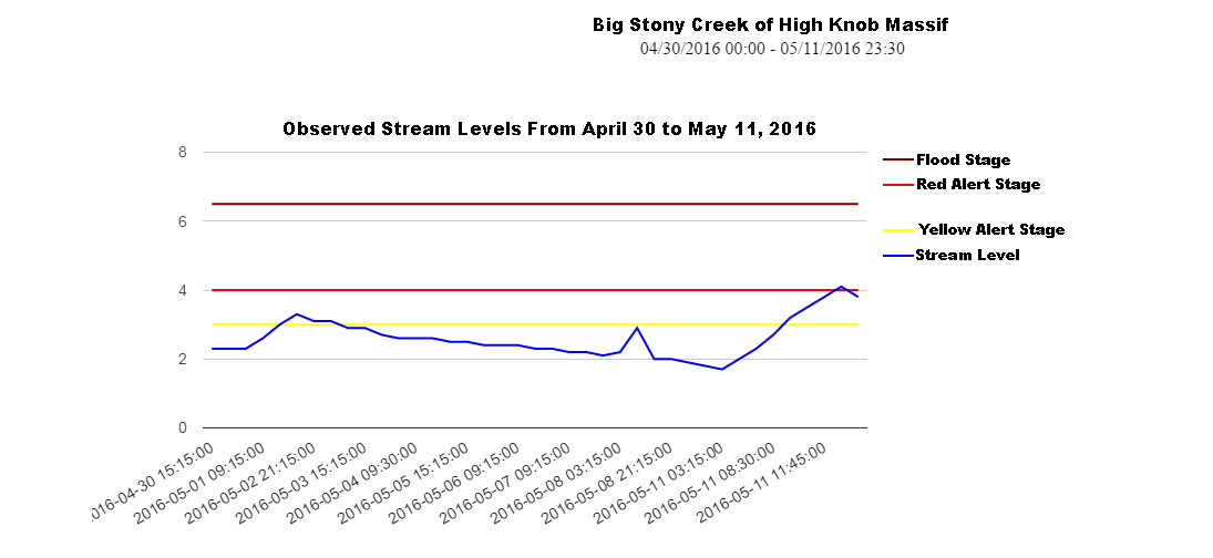
Big Stony Creek of High Knob Massif – May 2016
A vertical stream level rise of 2.4 feet generated roaring whitewater on Big Stony Creek ( draining 41.9 square miles of the High Knob Massif into northern Scott County ). This was the highest stream level observed so far in May. Strong rises, to gushing levels, were also observed on South Fork of the Powell River ( draining Big Cherry Lake Basin ) and on other steep creeks such as Clear Creek and the Little Stony along either side of the Wise County-Scott County border.
Head of Powell Valley and Grindstone Ridge of High Knob Massif
The heaviest rains fell above the great band of calcareous cliffs that ring much of the High Knob Massif, above which early-mid spring conditions currently exist verses late spring in valleys resting far below.
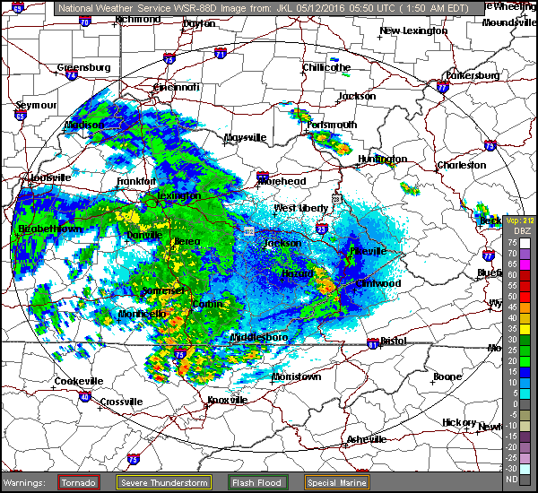
The focus during this early overnight of Thursday is once again on another batch of showers and downpours in thunderstorms moving across Kentucky.
As of 1:50 AM Thursday they are just beginning to develop into the mountains, in hit-miss fashion, along the High Knob Landform & Cumberland Mountains.
JKL Doppler At 1:50 AM Thursday – May 12, 2016
Short range models are struggling to capture this activity so uncertainty exists as to how much will make it into the mountains overnight into early Thursday. Since forecast models generally under-estimated rainfall amounts into early Wednesday, the potential for more downpours must be respected. Places that had heavy rain into Wednesday will be most likely to have strong rises on streams ( since the ground is already saturated ) if they have downpours.
Storm Prediction Center Risk RegionsSPC Discussion
Stay tuned to NOAA Weather Radio for any possible watches or warnings that might be needed.