Low clouds. Dense fog widespread at upper elevations into the overnight hours, then lifting bases possible by morning. Locally dense fog at middle to lower elevations. Scattered showers with local thunder & small hail possible ( drier to the west & southwest of Pennington Gap ). Light & variable winds. Temperatures dropping into the 40s to lower 50s.
Friday Afternoon
Cloud bases lifting. Becoming mostly to partly cloudy. Seasonally cool. W-SW winds 5-10 mph, with higher gusts, especially on mid-upper elevation ridges-plateaus. Temps varying from the mid-upper 50s in the upper elevations to the mid-upper 60s.
Friday Night Into Saturday Morning
Partly-mostly clear. Chilly. SSW-SW winds 5-10 mph, with higher gusts, along mid-upper elevation mountain ridges. Temperatures varying from the upper 30s to lower 40s in colder valleys of the upper elevations to the mid 40s to around 50 degrees ( milder ridges ). Areas of valley fog.
High Knob Hellbender 10K Race Forecast
A seasonally cool but dry race is forecast this year, with some low clouds and fog possible in a layer that could stream along the base-lower portions of the massif from Powell Valley during the morning, on light SW flow, prior to dissipating into partly cloudy skies as temps warm.
Some variations in temperature along the race course this year will include a start in the 50s ( following early AM lows in the 40s ) within downtown Norton, a rise to around 60 degrees above Legion Park and below the Flag Rock Recreation Area junction with State Route 619, then a fall back into the 50s with increasing elevation above Flag Rock ( these temps for the 10:00 AM to Noon period ).
Please note that breezy SSW-SW winds at upper elevations will make conditions feel more like the upper 40s to lower 50s.
10:00 AM Start In Downtown Norton
55 degrees – A Layer of fog and clouds will be possible just above downtown, along lower slopes of the massif, otherwise partly cloudy conditions are expected.
12:00 Noon At Summit of High Knob
54 degrees ( a crisp feels-like temperature of 48-52 degrees ) beneath partly cloudy skies. SSW to SW winds of 5-10 mph, with some higher gusts.
*This forecast is a go. Good Luck to all runners & walkers!
Saturday Afternoon
Partly-mostly sunny. Winds S-SW 5-10 mph, with some higher gusts ( especially on mid-upper elevation ridges ). Temperatures varying from upper 50s to lower 60s in the upper elevations to the upper 60s to lower 70s ( warmer southward into the Great Valley ).
Saturday Night Into Sunday Morning
Partly to mostly clear. Winds SSW-WSW winds 5-15 mph, with higher gusts, on middle to upper elevation mountain ridges. Temperatures varying from 40-45 degrees in cooler mountain valleys to the lower-middle 50s.
Weather Discussion ( Autumn Changes )
A significant weather change in conditions was observed during the Tuesday PM to Thursday PM period, as noted by these dramatically contrasting views from the High Knob Massif Webcam at UVA-Wise.
High Knob Massif Webcam – University Of Virginia’s College At Wise
From pristine autumn skies to a complete obscuring of upper elevations within low clouds and dense fog ( below ).
High Knob Massif Webcam – University Of Virginia’s College At Wise
Conditions in upper elevations of the High Knob Massif were chilly prior to this radical conditions change on September 29, as noted by these readings recorded on the High Knob Massif MesoNET.
High Knob Massif MesoNET – September 27, 2016
Although green still dominates the forest, and autumn color is running well behind its typical schedule in upper elevations of the High Knob Massif, some changes are occurring and many trees are now on the brink of changing-brightening with colorations.
Early Color Changes – Northern Slopes of High Knob Massif – September 28
Note along the crest of this high ridge that some trees are flagged, a rather atypical observation for deciduous northern hardwoods versus spruce-fir crestlines ( where coniferous growth is more conducive to flagging of limbs at high elevations ).
High Knob Massif MesoNET – September 28, 2016
AM MINS dipped into the upper 30s to lower 40s within colder mountain valleys during September 28 ( 42 degrees in Clintwood ). Coldest conditions occurring in places not impacted by dense fog. Wetland valleys upstream of Big Cherry Lake having dense fog on every night so far during September in places near Beaver dams.
Black Mountain MesoNET – September 29, 2016
Note wind chills into the lower 40s have been recorded at 4031 feet elevation by the Black Mountain MesoNET, with likely somewhat lower chills at places like High Knob Meadow ( Lookout ).
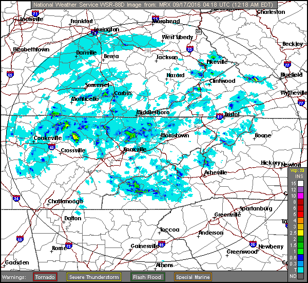
Conditions in upper elevations during September 29 were simply nasty, with dense fog all day across the High Knob Massif where numerous showers ( some with thunder-hail ) held temperatures in the 40s to lower 50s during the PM.
European Model 500 MB Analysis At 8 AM Thursday – September 29, 2016
A upper-level low has cut itself off from the main jet stream flow across North America. It will be key to conditions that are observed on Saturday for the High Knob Hellbender.
NAM 12 KM Model 925 MB RH Forecast At 10 AM Saturday
Looking ahead, my forecast for this year’s grueling climb from downtown Norton to the summit level of High Knob, the infamous High Knob Hellbender 10K Race, is dependent upon the current upper-level low moving enough to allow for drier air to stream into the area.
NAM 12 KM Model Forecast Sounding At 10 AM Saturday
Should this low be slower to move than models currently indicate, which is always possible with upper-lows, then a more cloudy race could result.
Partly to mostly clear. Areas of river valley and lake fog. Light winds becoming SW at 10-20 mph, with higher gusts, by morning on middle to upper elevation mountain ridges. Temperatures varying from 50s in cooler mountain valleys to the mid-upper 60s.
Monday Afternoon
Partly-mostly cloudy. A chance of showers-thunderstorms, then showers and thunderstorms becoming likely by late in the afternoon-early evening. More humid. Winds SW-WSW 10-20 mph, with higher gusts ( especially along mid-upper elevation mountain ridges ). Temperatures varying from upper 60s-lower 70s in upper elevations to the upper 70s to lower 80s ( warmer south into the Great Valley ).
Monday Night Into Tuesday Morning
Any evening showers ending. Turning chilly. Low clouds and dense fog at higher elevations above 2500-3000 feet. Winds becoming NNW-N at 5-10 mph, with higher gusts, on mid-upper elevation mountain ridges. Temps dropping into the 40s to lower-middle 50s ( warmer in lower elevation valleys of the Clinch, Powell, Holston river basins ).
Tuesday Afternoon
Becoming mostly sunny. Cool. Light WNW-NW winds. Temps varying from the 50s to lower 60s in upper elevations to the upper 60s to lower 70s.
Tuesday Night Into Wednesday Morning
Partly-mostly clear. Chilly. Winds WSW-WNW at mostly less than 10 mph on mid-upper elevation mountain ridges. Temperatures varying from mid-upper 30s in colder valleys to the mid-upper 40s. Areas of valley fog, especially along major rivers-lakes. Patchy frost possible in coldest valleys.
Numerous showers & thundershowers, some with possible hail due to cold air aloft, are being monitored for mid-late week amid chilly air associated with a slow moving upper-level low pressure.
Weather Discussion ( Autumn Arrives )
The big weather news this week will be the arrival of true autumn air, with chilly conditions expected to be felt across the mountains ( some will say cold given Summer 2016 ).
European 51-Member Ensemble MEAN 500 MB Height Anomalies
While low dewpoint air will pour into the mountains Tuesday, and linger into early Wednesday, it appears that a slow moving upper level low pressure will develop to dominate mid-late week.
European 51-Member Ensemble MEAN 850 MB Temps & Anomalies
This type of pattern would generate very chilly conditions, especially in upper elevations, with exact positioning and movement of the upper low helping to ultimately dictate day to day weather during September 28-October 1.
Partly-mostly clear. Areas of valley fog. E-SSE winds generally less than 10 mph along mid-upper elevation mountain ridges. Temps varying from 50-55 degrees within cooler mountain valleys to the low-mid 60s.
Friday Afternoon
Partly cloudy. Winds becoming N to NE at mostly less than 10 mph. Temperatures varying from 70-75 degrees in upper elevations to the upper 70s to lower 80s ( warmer south into the Great Valley ).
Friday Night Into Saturday Morning
Mostly clear. Winds N-NE at mostly less than 10 mph along mid-upper elevation mountain ridges. Temps varying from low-mid 50s in cooler mountain valleys to low-mid 60s. Areas of valley fog ( especially along main rivers-lakes ).
Saturday Afternoon
Partly cloudy. Winds NNW-NNE at mostly less than 10 mph. Temps varying from low-mid 70s in upper elevations to the low-mid 80s ( warmer south into the Great Valley ).
Saturday Night Into Sunday Morning
Partly-mostly clear. Areas of valley fog. Winds light & variable. Temperatures varying from 50s in cooler mountain valleys to the low-middle 60s.
Sunday Afternoon
Partly-mostly cloudy. Chance of a hit-miss shower or thunderstorm. Light winds. Temperatures varying from 70-75 degrees in the upper elevations to the lower-middle 80s ( warmer south into the Great Valley ).
The potential for the first mountain valley frost of the season, especially in mid-upper elevation valleys, is being monitored for the middle of next week ( fog will be likely in river valleys ). If a cut-off upper low develops over the region this will limit frost potential, so stay tuned for later updates.
Weather Discussion ( Nice Saturday )
A great weather day graced the 10th Annual High Knob Naturalist Rally during Saturday, with a large turn out enjoying the many activities offered.
Majestic Late PM Light In High Valley of High Knob Massif – September 24, 2016
As expected, the afternoon MAX reached the low-middle 70s following morning MINS in the low-mid 50s.
High Knob Massif High Valley MesoNET – 11:00 AM to 4:50 PM
The Saturday PM MAX reached 74 degrees at one high valley location, with another sensor located in the upper valley recording a MAX of only 72 degrees. Humidity levels and temps were higher than typical for this time of year, of course, but conditions did feel nice ( even cool through the morning ) in the shade during the PM.
Previous Discussion
A pleasant week of weather conditions in the mountains will continue into Saturday, with nearly ideal temperatures expected for the 10th Annual High Knob Naturalist Rally.
*As always this is sponsored by The Clinch Coalition and their supporters and is an awesome event for all ages. And it’s free, within the Clinch Ranger’s District’s Jefferson National Forest.
Fern Glade In Upper Valley of Big Cherry Basin – September 20, 2016
Max temperatures in the upper valley of Big Cherry Lake basin reached 74 degrees during September 11-20, with a mean daily high of around 71 degrees ( 3200 ft elevation ).
Conditions on Saturday ( September 24 ) should be similar amid the High Knob Lake Recreation Area, at an average elevation of 3500-3600 feet above mean sea level. Warm for this time of year, but pleasant versus lower elevations within the Clinch, Powell, and Holston drainage basins.
NAM 12 KM Model Total Rainfall Next 84-Hours
The NAM 12 KM Model, as well as the GFS and now European, are forecasting a chance for showers & thunderstorms to be on the increase during Sunday into Monday ahead of a cold front that should usher in the coolest air mass of the early autumn season by Tuesday-Wednesday ( September 27-28 ).
Operational European Model 850 MB Temp Anomalies – DAYS 5-9
The most recent European Ensemble MEAN has trended closer to the operational run of the model, increasing the odds that cooling will be significant during Sept 27-29.
European 51-Member MEAN 850 MB Temp Anomalies
Although the upper air trough next week will be progressive and lift back out, with upper ridge formation occurring once again, lingering lower dewpoint air in wake of the upper trough will allow nights ( especially in valleys ) to continue running on the cool side through the final days of September 2016.
Mostly clear. Areas of dense valley fog. Winds N-NE at 5-10 mph along mid-upper elevation mountain ridges ( mainly at or above 2700 feet elevation ). Temperatures varying from the low-mid 50s to around 60 degrees.
Tuesday Afternoon
Partly to mostly sunny. NE winds 5 to 15 mph, with some higher gusts along mountain ridges. Temperatures varying from upper 60s to low 70s in upper elevations to the upper 70s to lower 80s ( hotter south into the Great Valley ).
Tuesday Night Into Wednesday Morning
Mostly clear. Areas of valley fog. Winds NNE-ENE 5-10 mph with higher gusts on mid-upper elevation mountain ridges. Temperatures varying from 50-55 degrees in cooler valleys to lower-middle 60s.
Wednesday Afternoon
Partly-mostly sunny. NE-ENE winds 5-10 mph, with higher gusts. Temperatures varying from low-mid 70s in the upper elevations to lower-middle 80s ( hotter south into the Great Valley of eastern Tennessee ).
Wednesday Night Into Thursday Morning
Mostly clear. Areas of valley fog. Winds ENE-ESE 5-15 mph, with higher gusts, along middle-upper elevation mountain ridges. Temperatures varying from 50-55 degrees in cooler mountain valleys to lower-middle 60s ( exposed ridges ).
Thursday Afternoon
Partly-mostly sunny. ENE-ESE winds 5-10 mph. Temps varying from low-mid 70s in upper elevations to the low-middle 80s ( hotter south into the Great Valley ).
Weather Discussion ( Soaking Rain )
A real soaker of a rain fell across the mountain area during Sunday into the wee hours of Monday ( September 18-19 ).
National Weather Service Observations
Rain developed early and the PM MAX only reached 68 degrees in Clintwood during Sunday, amid a good amount of fog. The upper elevations in the High Knob Massif were obscured in dense fog, or orographic clouds, well into Monday morning.
Specific rainfall totals reached 1.87″ in the City of Norton, making 2.43″ in September and 43.38″ in 2016, with 2.08″ observed in Clintwood ( 2.18″ Sept / 32.69″ in 2016 ). More than 2.00″ of rain also fell across much of the High Knob Massif where 2016 totals are now 50.00-55.00″+ .
NAM 12 KM Model Total Rainfall Forecast Next 84-Hours
The mountain region is back into another dry stretch, being caught between heavy rainfall producing systems well to the northwest and east. Yes, again a subsidence regime will rule.
While a shower working in from the east or northeast can not be completely ruled out, most of the region along and west of the Cumberland Mountain range looks to remain dry.
GFS Model Total Rainfall Forecast To 8 AM Sunday – September 25, 2016
If conditions remain dry through Saturday that would be great news for the 10th Annual High Knob Naturalist Rally to be held in the majestic High Knob Lake Recreation Area.
*As always this is sponsored by The Clinch Coalition and their supporters and is an awesome event for all ages. And it’s free.
The first real cool shot of Autumn 2016 is still being tracked to arrive by the middle of next week. Initial indications are that the coolest air will move across the Great Lakes into the northeastern USA, but some impact is expected across the southern Appalachians ( stay tuned for details ).
Partly-mostly cloudy. Chance of a hit-miss shower or storm. Winds SSE-SSW 5-10 mph, with higher gusts, on mountain ridges-plateaus below 2700 feet. Winds S-SW at 10-20 mph, with higher gusts, on mountain ridges above 2700 feet. Temperatures varying from upper 50s to lower 60s in cooler valleys, with areas of fog, to mid-upper 60s.
Saturday Afternoon
Partly to mostly cloudy. Chance of scattered showers & thunderstorms. Winds SSW-SW 5-15 mph, with higher gusts, on mid-upper elevation mountain ridges-plateaus. Temperatures varying from lower 70s in upper elevations to the upper 70s to lower 80s ( hotter south into the Great Valley of eastern Tennessee and southwest Virginia ).
Saturday Night Into Sunday Morning
Mostly cloudy. Chance of a shower or thunderstorm. Winds SSW-WSW 5-15 mph mid-upper elevation mountain ridges. Temperatures widespread in the 60s.
Sunday Afternoon
Showers & downpours in thunderstorms likely. Locally heavy rainfall amounts. Winds becoming W-NW at 5-10 mph, with higher gusts. Temperatures varying from the lower 60s in upper elevations to upper 60s to lower 70s. Low clouds and fog along higher mountain ridges. Patchy fog possible in other locations.
Sunday Night Into Monday
Showers & thunderstorms giving way to showers. Locally heavy rain possible into the overnight. Areas of fog ( dense along higher mountain ridges ). Winds becoming WNW-N at 5-10 mph, with higher gusts, along mid to upper elevation mountain ridges. Temperatures varying from mid-upper 50s to the low-mid 60s ( coolest in upper elevations ).
Following a dry first-half to September it appears that a cold frontal boundary will finally bring some significant rainfall to the mountain area this weekend.
Doppler Rainfall Estimate For Friday – September 16
Local hit-miss downpours developed Friday ( above ), with more of the same possible Saturday before activity increases Sunday.
NAM 12 KM Model Total Rainfall Forecast To 2:00 PM Sunday – September 18
The main focus of heavier rains will be on Sunday for locales along and west of the Cumberland Mountains ( shifting east toward the Great Valley by late in the day ). Exact timing, of course, subject to change as activity actually develops.
NAM 12 KM Model Total Rainfall Forecast To 8:00 PM Sunday – September 18
If activity develops early along the Cumberland range the day will feature much lower temperatures and low clouds, with some orographic lifting across the high terrain.
European 51-Member Ensemble MEAN 500 MB Height Anomalies – DAYS 4 to 8
While much lower dewpoint air will again create some nice, cool nights during early-middle portions of next week, the current trend is for a rebuilding of 500 MB heights across the southeastern USA during September 20-24.
European 51-Member Ensemble MEAN 850 MB Temp Anomalies – DAYS 4 to 8
Daytime temperatures will again surge above average, with at least the potential for some more 90 degree days in the Great Valley ( especially if total rainfall is not heavy ).
Track Forecast For Typhoon Malakas
However, current extended trends suggest that heat next week will give way to MUCH cooler air and the first true shot of Canadian Chill during the final days of this month as a recurving typhoon in the western Pacific links up with the Polar Jetstream to force downstream changes in the flow pattern across North America. Stay tuned!
Partly-mostly clear. Areas of fog. Light winds. Temps varying from 50s in cooler mountain valleys to the mid-upper 60s on exposed middle elevation ridges-plateaus.
Wednesday Afternoon
Partly cloudy & warm. Chance of hit or miss showers and thunderstorms. NW-NNE winds 5-10 mph. Temperatures varying from 70s in upper elevations to the low-middle 80s ( hotter south into the Great Valley ).
Wednesday Night Into Thursday Morning
Becoming mostly clear following any early evening activity. Light NE-ENE winds generally less than 10 mph along mid-upper elevation mountain ridges. Areas of valley fog. Temps varying from upper 40s to lower 50s in cooler mountain valleys to the upper 50s-lower 60s.
Thursday Afternoon
Partly cloudy. Small chance of a hit-miss shower or storm. Light NNE to ENE winds. Temperatures varying from 70s in upper elevations to the lower-mid 80s ( hotter south into the Great Valley ).
Thursday Night Into Friday Morning
Partly-mostly clear. Winds ESE-SSE 5-15 mph along mid to upper elevation mountain ridges. Temperatures varying from 50s in cooler mountain valley to the mid-upper 60s.
Friday Afternoon
Partly-mostly cloudy. Chance of hit-miss showers-storms. SSE-SSW winds 5-10 mph, with some higher gusts. Temps varying from 70s in the upper elevations to lower-middle 80s ( hotter south into the Great Valley ).
Weather Discussion ( Weak Front )
An increase in the chance of showers & thunderstorms is expected into this weekend, following a drier than average first half of September 2016.
Above Ground Roots – Northern Woods Swamp Forest of High Knob Massif
The northern woods of the High Knob Massif remain damp, and if one did not know this area they would never know that September had been drier than average.
*The lower than normal lake level at Big Cherry Lake, due largely to much release during Summer 2016 to augment the Powell River, reveals that the regional pattern has been drier than average.
*Conditions In Upper Valley of Big Cherry Lake Basin on Sept 14
A simply HUGE contrast in conditions were observed during September 14 as afternoon temps in the valley dropped into the 60s, with clouds and local downpours, versus lower 90s at the same time in the Tri-Cities of the Great Valley.
*Conditions In Upper Valley of Big Cherry Lake Basin on Sept 15
Another large spread in conditions were observed during the afternoon hours of September 15, despite partly cloudy skies above the High Knob Massif.
*Data courtesy of Field Studies In Microclimatology at the University Of Virginia’s College At Wise using highly accurate, National Weather Service calibrated temperature sensors.
NAM 12 KM Model Total Rainfall Forecast Next 84-Hours
The NAM Model is showing the potential for some heavy rainfall by Sunday into Monday of September 18-19. Stay tuned for updates on this possibility.
Previous Discussion
The breaking news at the time of this update was the upgrade of Invest 93L to Tropical Storm Julia by the National Hurricane Center.
Infrared Satellite Image At 11:45 PM on September 13, 2016
The forecast going into Wednesday is for a weak front to move into the mountains and trigger hit-miss showers and thunderstorms into the afternoon. A wind shift then allows lower dewpoint air, at mid-upper elevations especially, to invade the Cumberland Mountains into Thursday morning.
National Hurricane Center Track For Julia
Although Julia is not expected to directly impact the local area, it could slow the weak boundary and/or aid sinking aloft and development of drier air depending upon its strength and movement. This is the uncertainty in the current forecast period that may need to be updated*.
*Temperatures into Thursday morning may not be as cool as I am currently forecasting in mountain valleys if the boundary is not able to push south-southwest of the High Knob Massif-Tennessee Valley Divide. On the other hand, if deep convection continues around Julia and it moves more east than north then sinking air aloft could reinforce the development of drier air over the area into Thursday-Friday ( dissipating the boundary and enhancing easterly to northeasterly flow into the area ).
European 51-Member Ensemble MEAN 500 MB Height Anomalies Forecast
In the big picture, on the synoptic-scale, nothing has really changed from my previous outlooks with an above average temperature pattern ( especially by day ) continuing. If the Tri-Cities do not reach 60 days of 90+ degree heat it will not be because this pattern is not favorable, especially given an increasing precipitation deficit across the Great Valley.
500 MB heights remain well above average during the next week to ten days, decreasing only slightly toward 588 dkm on the VA-TN border during the 6-10 day period ( September 19-23 ).
European 51-Member Ensemble MEAN 500 MB Height Anomalies Forecast
Although sun angles are decreasing and nights growing longer, the persistence of these anomalous heights over dry ground ( especially in the Tennessee Valley ) will continue to keep temperatures above model guidance.
Exceptions being on days that feature more cloudiness and/or showers-thunderstorms. Rainfall, for the most part, remaining limited into at least the beginning of this weekend as it looks now.
European 51-Member Ensemble MEAN 850 MB Temp Anomalies Forecast
The MEAN of the 51-Member European Model Ensembles is for temperatures to decrease a little, with emphasis being on little, amid the 6-10 day forecast period of September 19-23 ( below ). Looking at individual days; however, it would be no surprise for another day, or two, to hit 90 degrees in the TRI next week! If their ground can moisten then this threat may finally end.
European 51-Member Ensemble MEAN 850 MB Temp Anomalies Forecast
As I noted previously, it will likely be late September-early October before the southern Appalachians have a chance to actually feel a true push of autumn air.
As noted by the rapid spin-up of Julia, things can change quickly so stay tuned for updates. In this case, the synoptic-scale pattern has been rather stable to increase confidence in the persistence of this big picture setting for a while longer.
Cloudy with showers and possible thunder into early overnight, then a chance for rain showers into morning. Winds becoming NW-N at 5-10 mph, with higher gusts. Temperatures dropping into the mid 50s to middle 60s, coolest at highest elevations.
Sunday Afternoon
Becoming partly-mostly sunny. Cooler and less humid with refreshing air. Winds N-NE at generally less than 10 mph. Temperatures varying from 60s in upper elevations to the mid-upper 70s.
Sunday Night Into Monday Morning
Partly to mostly clear. SE-SSE winds mostly less than 10 mph along mid-upper elevation mountain ridges. Temps varying from mid-upper 40s in cooler mountain valleys to the mid-upper 50s. Areas of fog, especially along lakes and in main river valleys.
Monday Afternoon
Partly to mostly cloudy. Slight chance of a shower or sprinkle. Light SSE-SSW winds. Temperatures varying from low 70s in upper elevations to the lower 80s ( warmer south into the Great Valley ).
Monday Night Into Tuesday
Partly to mostly clear. S-SW winds 5-10 mph, with higher gusts, along mid-upper elevation mountain ridges. Temps varying from 50 to 55 degrees in cooler mountain valleys to the lower 60s. Areas of fog around lakes and rivers.
Weather Discussion ( Warm Trend )
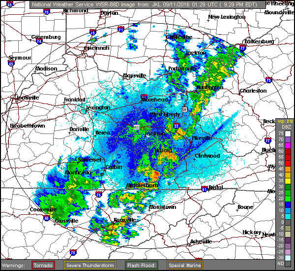
A cold front featuring scattered showers and local downpours will continue passing across the mountains Saturday night into Sunday morning.
Doppler Radar At 9:29 PM Saturday – September 10, 2016
A cooler, refreshing air mass follows during Sunday into Sunday night-Monday morning with another taste of early autumn in the mountains.
European 51-Member Ensemble MEAN 500 MB Height Anomalies – DAYS 3 to 7
Nothing has changed in the big picture from my previous outlook, with MEAN 500 MB Heights continuing to run above average with ridging over the southeastern USA ( above ) during the bulk of this coming week.
European 51-Member MEAN 850 MB Temp Anomalies – DAYS 3 to 7
Following cooling felt in the short-term this will return and continue the above to much above average temperature trend observed so far in September ( especially by day ).
Although the mountains will not reach 90 degrees, the Great Valley will have a chance to pad the all-time record number of 90 degree days now observed in the Tri-Cities.
Mostly clear. Areas of valley fog. WNW-NW winds mostly less than 10 mph on mid-upper elevation mountain ridges. Temperatures varying from 50s in cooler mountain valleys to the mid-upper 60s.
Thursday Afternoon
Partly cloudy. Unseasonably warm for the season. Light SW-W winds. Temperatures varying from 70s in upper elevations to the mid-upper 80s ( hotter south into the Great Valley of eastern Tennessee ).
Thursday Night Into Friday Morning
Partly-mostly cloudy. Areas of valley fog. Winds SW-WNW 5-10 mph along middle-upper elevation ridges & plateaus. Temperatures varying from upper 50s-lower 60s in cooler valleys to the upper 60s to around 70 degrees.
Friday Afternoon
Partly cloudy. More humid. Small chance of a hit-miss shower or thunderstorm. Light & variable winds. Temps varying from 70s in upper elevations to the middle-upper 80s ( hotter south into the Great Appalachian Valley ).
Friday Night Into Saturday Morning
Partly to mostly cloudy. Winds SSW-WSW at 5-10 mph, with higher gusts, along mid-upper elevation mountain ridges and plateaus. Temperatures widespread in the 60s.
Saturday Afternoon
Partly cloudy. Continued unseasonably hot for the season. Small chance of a hit-miss shower or storm. Winds SW-W at 5-10 mph, with higher gusts. Temps varying from 70s in upper elevations to the mid-upper 80s ( hotter south into the Great Valley ).
Saturday Night Into Sunday Morning
Partly-mostly cloudy. Small chance of showers. Winds becoming NW-NNE at 5-10 mph, with higher gusts, along mid-upper elevation mountain ridges-plateaus. Temps dropping into the mid 50s to mid 60s ( coolest at highest elevations ).
Low temperatures in the 40s and 50s will be likely by Sunday Night into Monday, with coolest conditions expected amid mountain valleys at middle-upper elevations.
Weather Discussion ( Dry & Warm )
The early Meteorological Autumn season of 2016 finds the Mountain Empire caught amid a dry weather pattern that is being dominated by a sinking air regime.
Wide Floor of High Elevation Wetland Valley In High Knob Massif – September 6
The sinking air has allowed for large day-to-night temperature spreads, especially amid higher mountain valleys, with 40s and 50s felt during this first week of September 2016.
Unseasonable warmth ( heat ) by day will continue through the first half of this weekend until a cold front passes by Saturday Night into Sunday. While a chance for showers, or a thunderstorm, in hit-miss fashion can not be ruled out most of the time ( and many places ) will remain dry.
European 51-Member Ensemble MEAN 500 MB Height Anomaly Forecast
While drier, lower dewpoint air, will again surge across the mountains Sunday into Monday, to generate more cool nights, unseasonable warmth returns by day as 500 MB heights remain well above average for this time during much of next week.
European 51-Member Ensemble MEAN 500 MB Height Anomaly Forecast
This could add on yet more 90s for the Great Valley to pad what by then will be an all-time record number of days with 90 degree or higher temperatures during a year.
European 51-Member Ensemble MEAN 850 MB Temp Anomaly Forecast
Cooler nights from Sunday into early next week are not really reflected on these graphics, since days trend back above to much above average, amid sinking air, to keep MEAN temperatures above average through much of next week.
European 51-Member Ensemble MEAN 850 MB Temp Anomaly Forecast
Although the change of seasons is really showing up at high latitudes, and high elevations in the Rockies, it appears that the Mountain Empire will have to wait until some point in the second half of September-early October before feeling more than just lower dewpoint ( dry air ) induced cooling at night ( i.e., a strong surge of true Canadian air ).
*Up to 10″ of snow was reported during this first week of September in Showdown, Montana, within the Little Belt Mountains well to the north-northeast of Bozeman.
The second half of September is getting close, so stay tuned as we watch autumn changes increase across the Northern Hemisphere during coming weeks.
Mostly clear. Cool. Areas of valley fog. Light winds. Temperatures varying from 40s in cooler mountain valleys of mid-upper elevations to the lower-middle 50s.
Sunday Afternoon
Partly-mostly sunny. Light N-NE winds mostly less than 10 mph. Temperatures varying from 60s at highest elevations to the upper 70s to lower 80s ( warmer in the Great Valley toward the Tri-Cities ).
Sunday Night Into Monday Morning
Mostly clear. Areas of valley fog. Light winds. Temperatures varying from upper 40s to lower 50s in cooler mountain valleys to the upper 50s to lower 60s.
Monday Afternoon
Partly-mostly sunny. Warmer. Winds NW-N generally less than 10 mph. Temperatures varying from low-mid 70s in upper elevations to the lower-middle 80s ( hotter south into the Great Valley of eastern Tennessee ).
Monday Night Into Tuesday Morning
Partly cloudy. Areas of valley fog. Winds WNW-NW at 5-10 mph along mid-upper elevation mountain ridges. Temps varying from 50s in cooler valleys to the mid-upper 60s.
Tuesday Afternoon
Partly cloudy. Winds WNW-NW 5-10 mph. Temps varying from 70s in upper elevations to the mid-upper 80s ( hotter south into the Great Valley toward the Tri-Cities ).
Late Summer-early Meteorological Autumn heat wave conditions are expected through mid-late week amid a subsidence regime of sinking air in the wake of western Atlantic tropical activity. Due to sinking air I have updated the forecast to reduce humidity, this will allow for significant day-to-night temperature spreads ( most pronounced amid mountain valleys ) and make heat tolerable until humidity increases along an initial front by next weekend into the middle of September ( current trend ).
Weather Discussion ( Summer Returns )
A welcomed and refreshing break from the muggy days of August is being enjoyed during this Labor Day Holiday.
Late Summer In High Wetland Valley of High Knob Massif
Temperatures have been in the 40s amid higher mountain valleys with 50s widespread across lower-middle elevations. Very nice!
Temperatures and Relative Humidity In Clintwood – September 4, 2016
A heavy dew has occurred in valleys as the air is approaching saturation in lower elevation mountain valleys at 3:30 AM.
European 51-Member Ensemble MEAN 500 MB Height Anomlies – DAYS 3-7
However, as I advertised last week, sinking air in the wake of Hermine will help rebuild a large upper ridge over the region with rising temperatures and late summer-early Meteorological Autumn heat wave conditions expected to redevelop during this week.
European 51-Member Ensemble MEAN 850 MB TEMP Anomaly Forecast
The 51-Member European Ensemble MEAN shows this well with above to much above average temperatures expected during the Tuesday-Saturday period ( September 6-10 ).
There is little doubt that this will be sufficient to allow the Tri-Cities to break the all-time record for the most 90s in a year ( or summer season ), especially given the continuation of dry ground versus average over the Great Valley.
Meteorological Summer Recap For The Great Valley Of Eastern Tennessee
Summer 2016 was a blaze amid the Great Valley, with 77 days at or above 90 degrees during June-August in Chattanooga, 57 days in Knoxville and 52 days in the Tri-Cities.
Meteorological Summer consists of June-August and ended up being the second warmest on record through the Great Valley.
The Summer 2016 average varied from 77.1 degrees in the Tri-Cities to 82.5 degrees in Chattanooga. This compares with observed averages in the 60s for upper elevations in the High Knob Massif to Black Mountain corridor of the Cumberland Mountains.
The June-August average temperature for Clintwood ended up at exactly 72.0 degrees.