An increasing chance of showers & downpours in thunderstorms will be observed Wednesday-Friday ( especially during afternoon-early evening hours ). Some storms may become strong to locally severe, on general principles, but torrential rainfall may end up being the main aspect that will need to be monitored most.
Overnight Into Tuesday Morning
Partly to mostly clear. Areas of fog. Light N-NE winds generally less than 10 mph along mid-upper elevation mountain ridges-plateaus. Temperatures varying from upper 40s to mid 50s in cooler mountain valleys to the upper 50s to lower 60s.
Tuesday Afternoon
Partly to mostly sunny. Warm & humid. Small chance of an isolated shower or thunderstorm. Light NNE to ENE winds at generally less than 10 mph. Temperatures varying from the low-mid 70s in upper elevations to the low-mid 80s.
Tuesday Night Into Wednesday Morning
CAUTION for Dense Fog between Little Stone Mountain Gap, and Powell Valley Overlook, and Big Stone Gap for travelers along U.S. 23 ( and old U.S. 23 heading into Appalachia ).
Partly to mostly clear. Areas of fog ( dense in Powell Valley and locations having heavy rain during Tuesday ). SE-SSW winds generally under 10 mph. Temperatures varying from 50s amid cooler mountain valleys to the low-mid 60s.
Wednesday Afternoon
Partly-mostly cloudy. Chance of showers & thunderstorms. Locally heavy rainfall possible. Light SE-S winds at mostly less than 10 mph ( outside any storms ). Warm & humid with temperatures varying from low-mid 70s at highest elevations to the lower-middle 80s.
Wednesday Night Into Thursday Morning
Chance of evening showers & thunderstorms. Partly to mostly cloudy. Areas of fog. Winds SSE to SSW 5-10 mph, with higher gusts, on mountain ridges-plateaus below 2700 feet. SSW-WSW winds 5-15 mph, with higher gusts, along mountain ridges above 2700 feet. Temperatures varying from the 50s to low-mid 60s.
Thursday Afternoon
Hit-miss showers & thunderstorms. Locally heavy rainfall. Winds SSW-WSW at generally less than 10 mph outside of storms. Temperatures varying from upper 60s to lower 70s in upper elevations to the mid 70s to around 80 degrees.
Thursday Night Into Friday Morning
A chance of showers & thunderstorms. Locally heavy rainfall possible. Areas of dense fog. Winds SSW-WNW at generally less than 10 mph outside of storms. Warm and humid with temperatures widespread in the upper 50s to lower-middle 60s.
Weather Discussion ( May 31-June 2 )
Early Wednesday Update
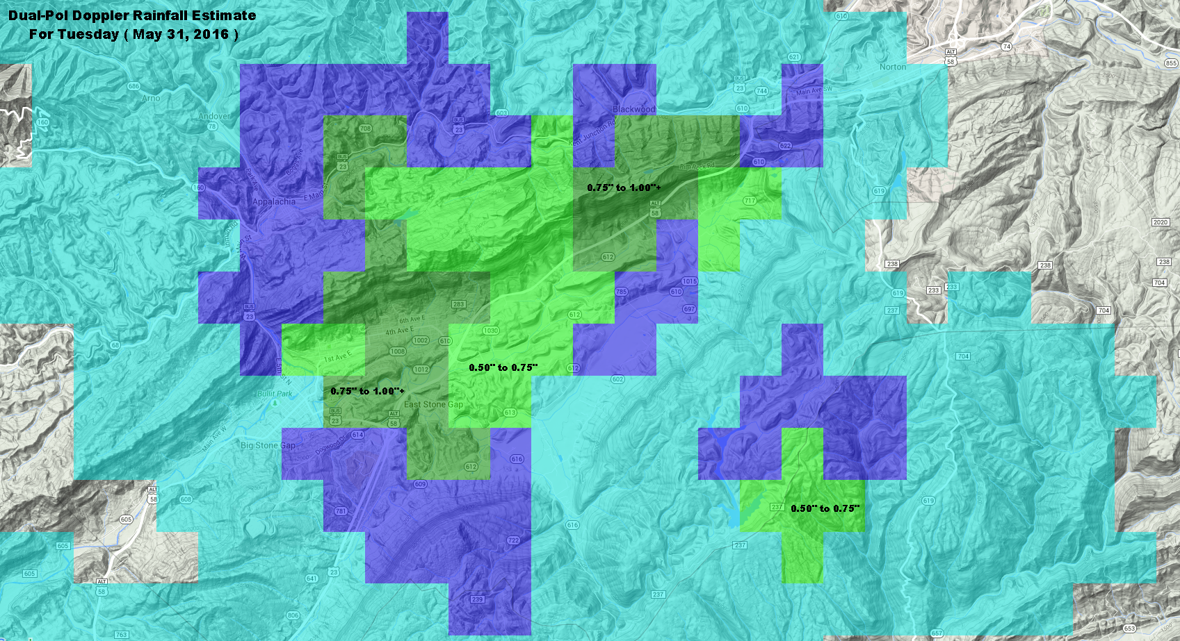
Local terrain triggered convection erupted in localized fashion during Tuesday, with torrential rainfall along the U.S. 23 corridor between Norton and Big Stone Gap.
Doppler Rainfall Estimate For Tuesday – May 31, 2016
A general 0.50″ to 1.00″+ of rainfall fell along U.S. 23 from near the Powell Valley Overlook, and Little Stone Mountain Gap, to the East Stone Gap area of Powell Valley. Heavy rain, which initially developed along Powell Mountain, moved across Little Stone Mountain to the Appalachia Lake Water Plant.
An area of rainfall developed earlier in the day ( early PM ) over portions of the Big Cherry Lake, Devil Fork and Straight Fork basins of the High Knob Massif, with 0.52″ of rain reported by a typically low reading automated gauge on Little Mountain. Other locations, by contrast, had little rain.
NAM 12 KM Model Total Rainfall Forecast To 8 AM Saturday – June 4, 2016
The hit-miss action of Tuesday is likely to be replicated on coming days, with heavy rainfall and strong storms hitting daily in different places. Any places that do get hit multiple times will be at higher risk for significant run-off and the possibility of strong water level rises.
GFS Model Total Rainfall Forecast Next 5 Days
Some models, like the GFS, are forecasting heavy rain amounts during the next 5 days. Models; however, are merely guessing at where the heaviest amounts will fall ( with a bias shown toward the major terrain features ). Only time will tell where heaviest total amounts will accumulate through coming days, which will partially ( at least ) be dictated by numerous sources that force convergence ( the coming together of air ) at low-levels.
Previous Discussion
Typical Memorial Day weather conditions were observed across the Mountain Empire, complete with some hit-miss showers & downpours in thunderstorms.
Memorial Day At Browning Family Cemetery – May 30, 2016
In Memory & Honor of all our loved ones lost and our veterans past and present – from the ridge top of Browning Family Cemetery.
Morning temperatures in the low-mid 50s in mountain valleys gave way to a mix of towering cumulus-cumulonimbus into the afternoon as temperatures climbed into the 70s and 80s.
Cumulus Tower Into The Heavens – May 30, 2016
Relatively dry air aloft created beautiful blue skies to set off towering afternoon-early evening cumulus ( tropical skies ).
Early Evening Cumulus Tower In Majestic Light – May 30, 2016
Light hitting a ridge top as the sun drops downward toward the western mountain horizon ( to left of above scene ).
Following a wetter and cooler than average May across much of the mountain area, the upcoming trend through the next 5 to 10 days is back toward a wetter and eventually cooler ( next week ) than average weather pattern for this time of year ( especially amid the mountains ).
European Ensembles 500 MB Height Anomalies Forecast – DAYS 1-5
A reversion back to an eastern USA upper air trough and western USA upper air ridge pattern is forecast to develop into next week.
European Ensembles 500 MB Height Anomalies Forecast – DAYS 6-10
The impact on temperatures can be seen below.
European Ensembles 850 MB Temp Anomalies Forecast – DAYS 1-5
Conditions go from above average during the first 5 days of this forecast period ( MEAN during May 31-June 4 ) to below average during the June 5-9 period ( MEAN ).
European Ensembles 850 MB Temp Anomalies Forecast – DAYS 6-10
The beginning of this pattern flip will dominate the short-term and be marked by an increasing chance for showers and downpours in thunderstorms during Wednesday into Thursday as the first cold front and upper air disturbance approaches the Appalachians.
NAM 12 KM Model Total Rainfall Forecast Up To 8 AM Friday – June 3, 2016
It is likely that some storms could become strong to locally severe given parameters being forecast by the high resolution NAM Model group for Wednesday afternoon and especially Thursday PM-early evening. Please stay tuned for updates.
This initial boundary will have a difficult time clearing the Mountain Empire as upper air troughing begins to develop and becomes reinforced by additional upstream fronts and disturbances into next week ( likely creating a stormy and unsettled period of weather that trends cool for this time of year over time ). Speaking of which, at this time of year any boundary that stalls must be closely watched given copious amounts of moisture available for showers & downpours in thunderstorms ( typically featuring widely varied rainfall amounts across the mountain landscape ).
While much dry time is expected, any shower or thunderstorm developing through this Memorial Day Holiday could contain locally heavy rainfall and always dangerous lightning.
Overnight Into Saturday Morning
Partly to mostly clear. Areas of dense fog ( especially in places that had rain on May 27 ). Winds SSE-SSW 5-10 mph, with higher gusts, along middle elevation mountain ridges and plateaus below 2700 feet. Winds S-SW 5-10 mph, with higher gusts, on mountain ridges above 2700 feet. Temps in the 50s to lower-middle 60s ( coolest in mountain valleys at middle-upper elevations ).
Saturday Afternoon
Partly cloudy and unseasonably warm. Chance of a hit-miss shower or thunderstorm. Light SSE-SSW winds at generally less than 10 mph. Temperatures varying from low-mid 70s in upper elevations to the lower-middle 80s ( upper 80s possible in lower elevations that have more sunshine ).
Saturday Night Into Sunday Morning
Partly-mostly cloudy. Chance of showers & thunderstorms. Light & variable winds ( outside any storms ). Warm with temperatures widespread in the upper 50s to upper 60s.
Sunday Afternoon
Chance of hit-miss showers and thunderstorms; otherwise, partly cloudy and warm. Light winds becoming WNW-NW at generally 10 mph or less. Temperatures varying from low 70s at highest elevations to the upper 70s to mid 80s.
Sunday Night Into Memorial Day Morning
Partly to mostly clear. Areas of fog. WNW winds 5-10 mph, with higher gusts, along middle-upper elevation mountain ridges ( especially above 2500-3000 feet ). Temperatures in the 50s to lower 60s ( coolest in mountain valleys ).
Memorial Day Afternoon
Partly cloudy. Chance of a hit-miss shower or thunderstorm. Winds WNW-NNW at 5-10 mph, with higher gusts, on middle-upper elevation mountain ridges-plateaus. Temperatures varying from low 70s at highest elevations to the upper 70s to low-mid 80s ( warmest at lower elevations to the south-southeast of the High Knob Massif-Tennessee Valley Divide ).
Weather Discussion ( May 27-30 )
Hit-miss showers & thunderstorms, some with downpours of heavy rain and booming thunder ( dangerous lightning ) developed over the mountain area Friday afternoon.
The heaviest corridor of rain stretched from southeastern Scott County north across Wise County to the Wise-Dickenson border, and across portions of the southeastern Kentucky foothills.
Rain Drops Galore On A Spider Web – May 27, 2016
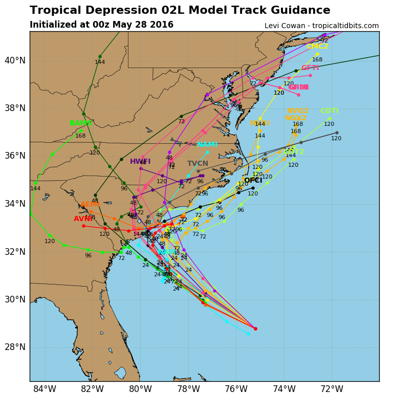
The second tropical cyclone of this season is expected to increase from Depression to Storm status before reaching the eastern Carolina’s during the Holiday Weekend.
Forecast Model Tracks For TD 2 – 8 PM May 27 Run
A Tropical Storm Warning is now in effect for the entire coastline of South Carolina, and may be extended into part of the North Carolina coast pending the exact track and strength of the system ( possible T.S. Bonnie ).
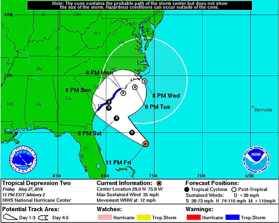
National Hurricane Center Official TrackNHC Discussion At 11:00 PM Friday – May 27, 2016
While the depression is still to cross the warm Gulf Stream, upper level shear will continue to hinder development beyond a low end Tropical Storm. Things can always change, but those are current indications based upon NOAA Hurricane Hunter data and forecast models. Heavy rainfall, with inland and coastal flooding, remains a concern and should be closely monitored by anyone with travel plans to central-eastern portions of the Carolina’s.
Pink Form of Common Yarrow ( Achillea millefolium )
Meanwhile, to the north and northwest the southern Appalachians are coming under the subsidence zone along the outer periphery of this developing tropical system.
USA Water Vapor At 1:15 AM on Saturday – May 28
Sinking air through mid-levels of the atmosphere is shown above by the circular shaped zone of clear ( dark ) air across much of Virginia and the eastern portion of Tennessee into Georgia.
Saturday is likely to be the hottest day of May 2016 with air sinking over the mountain area. This will be especially true for places that do not have convection or any significant cloud development during the afternoon.
While synoptic-scale subsidence will generally work against convective development during the daylight hours of Saturday, some local terrain forced activity can not be completely ruled out and must remain in the forecast. Chances increase again into Saturday Night and Sunday as the atmosphere becomes more conducive again for rising air ( the subsidence zone weakens for locations along and west of the Cumberland Mountains ).
Remember that any thunderstorm development through the Memorial Day Holiday could contain downpours of rain and always dangerous lightning. Stay safe and have a great Holiday Weekend-Monday.
Partly to mostly clear. Areas of valley fog. Cool. Light winds below 2700 feet. SW winds 5-10 mph, with a few higher gusts, along mountain ridges above 2700 feet. Temperatures in the 40s and 50s, coolest in mountain valleys with 40 to 45 degrees in colder valleys.
Wednesday Afternoon
Becoming mostly cloudy and more humid. A chance for hit-miss showers & thunderstorms. Local downpours possible. Winds SSW-SW 5-10 mph, with higher gusts along ridges. Temperatures varying from the 60s in upper elevations to the mid-upper 70s.
Wednesday Night Into Thursday Morning
Mostly cloudy. Humid. A chance of evening showers and thunderstorms, then possible redevelopment by morning. Winds SSW-WSW at 5-10 mph along mid-upper elevation mountain ridges. Warm with temperatures in the 50s to lower 60s. Areas of haze and valley fog.
Thursday Afternoon
Partly-mostly cloudy. Hazy. A chance of hit-miss showers and thunderstorms. Local downpours possible. Winds light, except SSW-SW at 5-10 mph along middle-upper elevation mountain ridges. Temperatures varying from 60s to low 70s in upper elevations to the upper 70s to lower 80s.
Thursday Night Into Friday Morning
Any evening showers-storms dissipating. Partly to mostly clear into the overnight with haze and areas of fog. Humid. Winds SSW-SW at 5-10 mph, with higher gust, along middle to upper elevation mountain ridges. Warm with temps in the 50s to lower-middle 60s.
Weather Discussion ( May 2016 )
A final cool night amid what has been a long series of chilly nights ( dominating the May 14-25 period in the mountains ) is poised to give into summer-like humidity.
Golden Orb Weaver ( Nephilidae Family ) Species Working In Late May
A wet May 2016, with 6.37″ of rain officially measured in Clintwood, will get wetter in coming days for some as hit and miss showers and local downpours in thunderstorms develop across the mountain landscape as humidity rises.
Crown-tipped Coral ( Clavicorona pyxidata ) Growing Amid May Wetness
Forecast models are trying to guess where rain will fall during coming days, but in reality that is a very difficult thing to do when rainfall will largely be air mass-terrain driven without any distinct focus over the southern Appalachians ( unlike in the central Plains ).
NAM 12 KM Model Total Rainfall Forecast Next 84-Hours
While not cancelling any outdoor plans heading into the first big holiday to kick off Summer 2016, keep in mind that showers and thunderstorms will be developing in mostly a hit-miss fashion across the mountain landscape. Some of these will likely have downpours of rain, along with always dangerous lightning, so have a backup plan and be prepared to seek shelter.
Development odds often favor locations in and near the major terrain features, with subsequent storm motion and formation then being dictated by outflow boundaries that form as cool air rushes outward from the initial convection to trigger new stuff amid what often appears, at least, to be chaos.
GFS Model Total Rainfall Forecast Next 84-Hours
It remains to be seen how a disturbance over the western Atlantic will impact conditions by later this weekend into early next week, so stay tuned for updates.
A pocket of cold air aloft will increase the possibility of mid-late afternoon & evening showers during Sunday. Local thunder and small hail will be possible with the most well developed activity due to steep lapse rates ( 60-70 degree differences between the surface and 18,000 feet in the atmosphere ).
Overnight Into Sunday Morning
Mostly cloudy. Chance of showers. NW winds 5-15 mph, with higher gusts, along middle elevation mountain ridges and plateaus below 2700 feet. NW-N winds 5-20 mph, with higher gusts, on mountain ridges above 2700 feet. Temps varying in the 40s to lower-middle 50s ( coolest at highest elevations ). Wind chills in the upper 30s to lower 40s in gusts at highest elevations. Dense fog at elevations above 2700-3300 feet.
Sunday Afternoon
Partly to mostly cloudy. Chance of showers, especially by mid-late afternoon. Thunder & localized small hail possible. WNW-NNW winds 5-15 mph, with higher gusts ( especially along mountain ridges-plateaus ). Temperatures varying from 50s to around 60 degrees in upper elevations to the middle 60s to lower 70s.
Sunday Night Into Monday Morning
Chance of evening showers. Thunder & localized small hail possible. Becoming partly to mostly clear overnight. Areas of fog. NNW-NNE winds 5-15 mph on mid-upper elevation mountain ridges & plateaus. Temperatures in the 40s to around 50 degrees.
Monday Afternoon
Partly to mostly sunny. Winds N to NE winds 5-10 mph. Temperatures varying from 50s in upper elevations to the middle 60s to around 70 degrees.
Monday Night Into Tuesday Morning
Mostly clear. Light winds. Seasonally cool with temps in the 40s to lower-middle 50s ( coolest in mountain valleys with cold air drainage ).
A warmer pattern featuring hit-miss showers and thunderstorms is expected during mid-late week. Locally heavy rainfall will be possible with some of the thunderstorms.
Weather Discussion ( May 21-24 )
A continuation of seasonally cool, damp conditions have been observed into this May 21-22 weekend, with limited sunshine across the mountain landscape.
*A general 0.50″ to 1.00″ of rain Friday Night, in counties along the Virginia-Kentucky border, being limited by vigorous Deep South convection.
High Knob Massif Webcam – University Of Virginia’s College At Wise
Saturday PM temperatures varied in the 50s ( above 3000 feet ) and 60s, across lower-middle elevations ( 64 degrees at Nora 4 SSE and 69 degrees at Clintwood 1 W ), amid limited sunshine and hit-miss showers featuring a few brief downpours.
Nora 4 SSE – NWS Station In Middle Elevations
Conditions late Saturday evening into the start of this Sunday are coolest in upper elevations where breezy to gusty NW-N winds are creating wind chills in the low-mid 40s.
Black Mountain MesoNET – Midnight To 1:00 AM Sunday – May 22, 2016Black Mountain MesoNET – Up To Midnight ( Sunday – May 22, 2016 )
While the weather focus will be shifting toward a warmer and more summer-like pattern into next week, there will be one more day ( Sunday ) when a pocket of cold air aloft over the mountains will steepen lapse rates ( the temperature drop with increasing height ) enough to trigger instability showers into mid-late afternoon and the early evening.
A few of the more vigorous showers will have the potential for localized small hail and thunder due to this unseasonably cold air aloft ( -4 degrees Fahrenheit below zero at 18,000 feet ).
Hairy Petunia Hybrid – Sherri’s Sassy Scissors In Clintwood, Virginia
The beauty of late Spring will be fading into early Summer soon, with conditions trending that way during this new work week toward the Memorial Day Holiday.
Dwarf Hybrid Hibiscus – Sherri’s Sassy Scissors In Clintwood, Virginia
The transition from this current cooler than average regime to one more like summer is shown well by the 51-Member European Ensemble group.
European 51-Member Ensemble 850 MB Temp Anomalies Forecast – DAYS 1-5
Temperatures will be going from below average to above average heading into late week and the Memorial Day Holiday.
European 51-Member Ensemble 850 MB Temp Anomalies Forecast – DAYS 6-10
Hit-miss showers & thunderstorms, mainly in the afternoon-evening hours, will become part of this pattern as main upper ridging develops over New England.
European 51-Member Ensembles MEAN 500 MB Height Anomalies – DAYS 6-10
ALERT For Widespread Dense Fog Continues Into Thursday AM At Middle-Upper Elevations Along & North Of The High Knob Massif-Tennessee Valley Divide – Patchy Fog Possible In Other Locations
Widespread low clouds will continue to obscure middle to upper elevations, with periods of drizzle, into the overnight-morning hours of Thursday in locations along and north of the High Knob Massif-Tennessee Valley Divide on northerly upslope flow. Cloud bases should begin to lift and dense fog-clouds break during the sunrise to mid-morning period on Thursday ( May 19 ).
Overnight Into Thursday Morning
Low clouds. Periods of drizzle. Chilly. Winds N-NE at 5-10 mph, with higher gusts, along upper elevation ridges. Temperatures in the 40s to around 50 degrees.
Thursday Afternoon
Partly cloudy or becoming partly cloudy. NE winds generally less than 10 mph. Temperatures varying from the 50s across upper elevations to the middle-upper 60s.
Thursday Night Into Friday Morning
Partly cloudy during the evening with increasing clouds overnight into morning. Winds ESE-SSE 5-15 mph along middle-upper elevation mountain ridges-plateaus. Temps in the 40s to lower-middle 50s ( coolest mountain valleys ).
Friday Afternoon
Showers developing ( especially late ). Winds SE-S at 5-15 mph, with higher gusts. Temperatures varying from the 50s at highest elevations to the middle 60s to lower 70s, warmest at lower elevations in basins of the Russell Fork and Levisa Fork of the Big Sandy River.
Friday Night Into Saturday Morning
Rain with a chance of thunderstorms. Rain may be heavy at times. Winds SE-SSW at 5-15 mph, with higher gusts, along mountain ridges-plateaus below 2700 feet. S-SW winds 10 to 20 mph, with higher gusts, along mountain ridges above 2700 feet. Temperatures widespread in the 50s.
The potential for heavy rainfall amounts is being monitored for the Friday Night-Saturday Morning period. Strong rises on creeks will be possible, given wet May conditions ( 5.00-6.00″+ rain tallies observed during May 1-18 from the High Knob Massif into portions of the Russell Fork Basin of northern Wise & Dickenson counties ), should rainfall become heavy. Stay tuned for updates.
Weather Discussion For May 18-21
Low clouds, showers, and persistent afternoon-evening drizzle created a chilly, damp Wednesday for locations in and north of the High Knob Massif-Tennessee Valley Divide.
High Knob Massif Webcam – University Of Virginia’s College At Wise
It was a particularly nasty day amid upper elevations with dense fog all day long above 2700 feet. This combined with temperatures in the 40s, within the High Knob Massif, to put a true chill into the air on breezy to occasionally gusty northerly winds.
High Knob Massif Webcam – University Of Virginia’s College At Wise
Cloud bases which were on and off the Wise Plateau up through Noon Wednesday dropped to obscure much of the area in persistent, dense fog from 2:00 PM to present ( 10:00 PM ).
High Knob Massif Webcam – University Of Virginia’s College At Wise
Non-radar detectable drizzle has also been a persistent feature.
Although cloud bases were just above Clintwood, the nature of this day was illustrated by a AM MIN of 54 degrees and a PM MAX of 55 degrees ( a mere 1 degree of change on the official National Weather Service MMTS System ).
Nora 4 SSE – NWS Station In The Middle Elevations
Higher up, amid middle to upper elevations, the mildest temps were observed around sunrise with a steady drop during the day as winds turned to a northerly upslope direction ( readings falling from 50s into the 40s ).
Black Mountain MesoNET
Wednesday evening temperatures have settled into low-mid 40s amid upper elevations in the High Knob Massif and Black Mountain, with enough wind to make it feel like 30s in gusts along the high ridges.
Yellow Flag Iris ( Iris pseudacorus ) – May 17, 2016
Official temperatures at and above 2700 feet have not gotten above 60 degrees since May 13, amid an extended period of unseasonably cool mid-May conditions in the mountains.
Fly ( Diptera Order ) On Waving Yellow Flag Leaf – May 17, 2016
Focus now shifts to a brief break Thursday before another storm system, taking a cold season track, spreads rain back across the southern Appalachians Friday PM-Friday Night.
Forecast models have not been consistent, from run to run, on rainfall amounts so please stay tuned for updates as a consensus is hoped for on new model runs upcoming through Thursday. The storm track & recent pattern suggests that heavy rainfall will be possible with this system ( especially if Deep South convection does not get “out of hand.” ).
ALERT For The Potential Of Dense Fog As Cloud Bases Drop From Upper Elevations Into Middle Elevations By Wednesday Morning For Locations Along & North Of The High Knob Massif-Tennessee Valley Divide. Caution For Travelers Is Advised.
A redevelopment of showers, with dropping cloud bases, on a northerly wind shift is expected into the predawn-morning hours of Wednesday. Conditions will continue to be cooler than average for this time of year, especially for locations along and north of the High Knob Massif and Tennessee Valley Divide.
Overnight Into Tuesday Morning
Showers developing. Thunder possible. SSE-SSW winds increasing to 5-15 mph, with higher gusts, along middle elevation mountain ridges-plateaus. SSW to SW winds increasing to 10-20 mph, with higher gusts, along mountain ridges above 2700 feet. Temperatures widespread in the 40s to lower 50s.
Tuesday Afternoon
Showers & thunderstorms becoming likely. Locally heavy rainfall. SW winds 5-15 mph, with higher gusts, becoming northerly. Temperatures varying from the 50s to middle 60s ( coolest in upper elevations ). Dense fog across upper elevations, with patchy fog in other locations.
Tuesday Night Into Wednesday Morning
Chance of evening showers, then showers becoming likely by the predawn-morning. Dense fog possible along middle-upper elevation ridges-plateaus. N-NE winds at generally less than 10 mph. Temperatures widespread in the 40s to lower-middle 50s.
Wednesday Afternoon
Cloudy & chilly. Chance of rain. Low clouds. Winds NNE-ENE at 5-10 mph, with higher gusts along middle to upper elevation mountain ridges-plateaus. Temperatures in the upper 40s to mid-upper 50s ( coolest in upper elevations ).
Wednesday Night Into Thursday Morning
Low clouds. Chance of showers & drizzle. Chilly. Winds NE to ESE at generally less than 10 mph. Temperatures in the 40s to around 50 degrees.
Weather Discussion For May 16-18
Late Tuesday PM Update
Another cooler than normal day for this time of year once again featured temperatures struggling to break 60 degrees in locations along and north of the High Knob Massif.
Nora 4 SSE – NWS Station In Middle Elevations
Afternoon MAXS reached 60 degrees at Nora 4 SSE and 63 degrees in Clintwood ( with 0.41″ of total rainfall / 5.53″ in May ).
Black Mountain MesoNET
Tuesday PM ( May 17 ) temperatures remained in the 50s for places above 2700 feet in elevation, despite a continuation of southerly air flow. A shift to northerly wind direction is delayed on latest model runs until the predawn-morning hours of Wednesday.
High Knob Massif Webcam – University Of Virginia’s College At Wise
Following mid-morning to early afternoon showers, low clouds, and areas of fog some welcomed early evening breaks in the overcast have developed above Wise.
Temperatures are expected to cool some on Wednesday with northerly flow for locations along and north of the High Knob Massif and Tennessee Valley Divide.
Previous Discussion
A cold & frosty morning greeted the new work week into Monday with WIDESPREAD ( not patchy ) frost observed throughout the mountain valleys and hollows of central-northern Wise and Dickenson counties.
Skies became mostly clear into Sunday night ( below ) with dewpoints below freezing at middle-upper elevations.
High Knob Massif Webcam – University Of Virginia’s College At Wise
Freezing temperatures were even reported into portions of the typically milder Clinch River Valley, with 32 degrees and some minor plant damage observed in The Pines section near the community of Dungannon into Monday morning.
Why would this not occur, with dewpoints in the 20s to around 30 degrees from the elevation of Norton-Wise on upward under decreasing winds and mostly clear skies.
MIN temperatures varied from the upper 20s to lower 30s in many valleys, with an official MIN of 33 degrees observed in Clintwood. The MIN reached 30 degrees in Norton.
*NOTE for those asking, temperatures reported by WCYB are not located in Clintwood but are in the South of the Mountain area in the Ramey Flats community ( north of the Pound River ). This site tends to be warmer on cold air drainage nights than valleys such as the Holly Creek Valley ( Clintwood ) and Georges Fork area.
The Weatherbug station at Norton Elementary School is not “officially” online and has been reportedly flagged by AWS for a temperature error that seems to be most pronounced ( but likely exists all the time ) during nights with cold air drainage into the Norton valley.
High Knob Massif Webcam – University Of Virginia’s College At Wise
Mid-high cloud did increase rapidly into Monday morning such that day-time MAX temps into the afternoon remained cooler than I had anticipated at lower-middle elevations along and north of the High Knob Massif.
Nora 4 SSE – NWS Site In The Middle Elevations
It was a struggle for temperatures to reach into the 50s from Norton-Wise to Clintwood and the adjacent ridge communities ( 57 degrees being obtained in Clintwood ).
NAM 12 KM Model Rainfall Forecast Next 84-Hours
While there are some significant differences in model forecast rainfall amounts during the next few days, the general pattern will be damp and cooler than normal for this time of year.
GFS Model Rainfall Forecast Next 84-Hours
The high resolution NAM Model is looking particularly nasty for locations along and north of the High Knob Massif for Tuesday and Wednesday, with low cloud bases developing on northerly upslope flow. I have already posted an ALERT for the potential of DENSE FOG at middle-upper elevations for later Tuesday into Wednesday morning. Stay tuned for updates to see if this may need to be changed or extended.
*The above requires advance warning since travelers along U.S. 23, for example, tend to run from no fog into dense fog upon driving up Indian Creek Mountain onto the Wise Plateau from the north, and from Powell Valley toward Little Stone Mountain Gap and the Overlook area from the south. Rapid drops in visibility upon going into clouds are very dangerous for motorists unaware.
ALERT For Mountain Valley Frost Formation Sunday Night Into Monday Morning – Especially For Locations Along & North to Northeast Of The High Knob Massif
Below freezing temperatures will occur at highest elevations into Sunday Morning, amid unseasonably cold wind chills, with limited frost potential across middle to lower elevations where skies stay cloudy. If skies clear overnight the threat for frost will increase within mountain valleys into Sunday Morning.
Partly to mostly clear skies, low dewpoints, and light winds will promote more favorable conditions for frost formation in valleys during Sunday Night into Monday Morning. Min temperatures in the upper 20s to middle 30s are expected, with coldest conditions within mid-upper elevation valleys in the High Knob Massif to Burkes Garden corridor of southwestern Virginia.
Widespread frost will be possible on valley floors and impact communities such as Addington, Big Laurel, Burkes Garden, Coeburn, Dante, Elk Garden, Georges Fork, Nora, Norton, Ramsey, Stephens, Tacoma, Tazewell and Trammel ( to note only a few ). Shady Valley and other typically cold valleys in NE Tennessee and NW North Carolina will also be at risk.
Little to no frost is currently expected on exposed middle elevation mountain ridges & plateaus, and within major river valleys where fog formation will be likely along rivers such as the Clinch, Powell, Holston, Cumberland, and in lower portions of the Russell Fork and Levisa Fork drainages.
Overnight Into Sunday Morning
Partly to mostly cloudy. Cold. Gusty WNW-NW winds 5-15 mph, with higher gusts, along mountain ridges below 2700 feet ( decreasing some into morning ). NW-N winds 10-20 mph, with higher gusts, along mountain ridges above 2700 feet. Temperatures dropping the 30s, except 20s to around 30 degrees in colder locations at the highest elevations. Wind chills in the 20s along upper elevation mountain ridges ( 10s in gusts on the highest peaks ).
Sunday Afternoon
Mostly sunny. Deep blue skies. Unseasonably cool. Winds WNW at 5-15 mph, with higher gusts. Temps varying from the 40s in upper elevations to the upper 50s to low-mid 60s.
Sunday Night Into Monday Morning
Mostly clear evening skies with some increasing high clouds overnight into morning. W-NW evening winds shifting N to NE into morning at under 10 mph. Temperatures varying from 30s to lower 40s on mid-upper elevation mountain ridges-plateaus to the 20s to lower 30s in colder valleys with patcy to widespread frost formation. Fog possible within major river valleys and around large lakes.
Monday Afternoon
Increasing clouds. Milder. ESE-SSE winds at generally less than 10 mph. Temperatures varying from 50s across upper elevations to the 60s in lower-middle elevations.
Monday Night Into Tuesday Morning
Showers developing. Thunder possible. SSE-SSW winds increasing to 5-15 mph, with higher gusts, along middle elevation mountain ridges-plateaus. SSW to SW winds at 10-20 mph, with higher gusts, along mountain ridges above 2700 feet. Temperatures in the 40s to lower-middle 50s.
Tuesday Afternoon
Showers & thunderstorms becoming likely. Locally heavy rainfall. SSW-SW winds 5-15 mph, with higher gusts, along mountain ridges-plateaus below 2700 feet. SW-WSW winds 10-20 mph, with higher gusts, along mountain ridges above 2700 feet. Temperatures in the 50s to lower-middle 60s.
Weather Discussion ( May 14-17 )
A gusty and colder air mass moved into the mountains during Saturday with falling afternoon temperatures felt along and north of the High Knob Massif.
High Knob Massif Webcam – University Of Virginia’s College At Wise
Saturday afternoon ( May 14 ) temperatures fell through the 50s into the 40s amid middle elevations along and north of the High Knob Massif ( locations between 2000 & 3000 feet ). This included Norton, Wise, and adjacent communities.
Nora 4 SSE – National Weather Service Station In Middle Elevations
Locations above 3000 feet, amid the upper elevations, saw temps drop through the 40s into the 30s.
Black Mountain MesoNET – Temperatures & Moisture Graphs
Temperatures dropped into the 30s between 4:00 to 5:00 PM atop the High Knob Massif and Black Mountain, with much colder wind chills on gusty NW winds.
NASA Visible Image At 1:00 PM on May 14, 2016
Breaks in the overcast occurred lee of the Cumberland Mountains and adjacent Cumberland Plateau, with some low-level terrain blocking also slowing down the cold air advection.
The result was large temperature differences between locations along and north-northwest of the High Knob Massif verses places to the south and southeast ( 30s and 40s verses 50s and 60s ).
NASA Visible Image At 7:00 PM on May 14, 2016
Focus on Saturday Night into early hours of the overnight were on partly-mostly cloudy skies and temperatures that had already dropped below freezing at highest elevations.
Black Mountain MesoNET Up To 2:15 AM on Sunday – May 15, 2016
At 2:15 AM a air temperature of 30 degrees combined with N wind gusts to 20 mph to generate a 17 degree wind chill factor at the 4031 foot elevation of the Black Mountain Mesonet site located along the Virginia-Kentucky border ( near Harlan-Wise line ).
NAM Model Forecast Sounding Above Wise At 8 PM Sunday – May 15, 2016
Forecast soundings above Wise show that the air dries significantly into Sunday with deep blue skies like autumn ruling the mountain landscape through the afternoon.
Although an increase in high altitude cloudiness is shown into Monday morning ( below ), the low-level air remains very dry with dewpoints in the 20s amid middle to upper elevations being conducive for strong radiational cooling and development of cold air drainage flows into mountain valleys during Sunday Night.
NAM Model Forecast Sounding Above Wise At 8 AM Monday – May 16, 2016
The threat for widespread frost must be respected, especially in mountain valleys of Wise, Dickenson, Russell and Tazewll counties where air will be driest at 900-800 mb. A freeze being possible in colder locations.
Little to no frost is expected on exposed middle elevation mountain ridges & plateaus, and within major river valleys where fog formation will be possible along rivers such as the Clinch, Powell, Holston, Cumberland, and in lower portions of the Russell Fork & Levisa Fork drainages.
Mushroom Grow Amid May Wetness – May 14, 2016
Focus into the new work week shifts back to wetness, with showers and downpours in thunderstorms expected to return by Monday Night into Tuesday.
NAM 12 KM Model Total Rainfall Forecast To 8 AM Wednesday – May 18, 2016
May 2016 has already produced as much or more rainfall than March+April combined in many places along the mountainous Virginia-Kentucky border.
There Is An Increasing Risk For Frost In Mountain Valleys In Coming Days, Especially By Sunday Night Into Monday AM – Please Stay Tuned For Updates
Temperatures will drop to around freezing at highest elevations in the High Knob Massif during Saturday Night Into Sunday Morning. An abundance of upslope clouds, on WNW flow, will limit the frost potential during this time. However, drier air and low dewpoints will combine with light winds beneath High Pressure to generate strong radiational cooling and cold air drainage into mountain valleys during Sunday Night into Monday Morning.
There will be potential for high clouds into Monday AM, but they may not be thick enough to prevent temperatures from falling to around or below freezing in colder mountain valleys ( MINS are currently expected to drop into the 20s to low-mid 30s in valleys, with coldest conditions in mid-upper elevation valleys at 2000 to 3000+ feet above sea level within the High Knob Massif to Burkes Garden corridor of southwestern Virginia ).
A heavy frost-freeze potential will be possible in and around such communities as Norton-Ramsey, Tacoma-Coeburn, Tazewell and Burkes Garden ( to note a few places ).
I will issue a new forecast late Saturday to cover this potential.
Previous Alerts & Statements
ALERT For High Stream Levels And Ponding Of Water In Poor Drainage & Low Lying Areas Of Northern Wise and Dickenson Counties Into Thursday Evening
*A rainfall total of 1.85″ has been officially measured in Clintwood since Midnight, with 1.45″ since Noon Thursday. Poor drainage and street flooding has occurred, with high stream levels in the area. Caution Is Advised.
The RLX NWSFO has included Dickenson & Buchanan counties in a Flash Flood Watch Until 8:00 AM Friday
The Storm Prediction Center Maintains A Marginal Risk For Severe Thunderstorms Through Thursday Night – Stay Tuned To NOAA Weather Radio And Severe Weather Alert Systems For Any Possible Watches Or Warnings Which May Be Needed
Overnight Into Thursday Morning
Showers & thunderstorms developing. Downpours likely. Winds SW-WSW 5-15 mph along mountain ridges-plateaus below 2700 feet. WSW to WNW winds 5-15 mph, with higher gusts, along mountain ridges above 2700 feet. Temperatures in the 50s to low-mid 60s.
Thursday Afternoon
A chance of hit-miss showers & thunderstorms. Warm and humid. S-SW winds 5-15 mph, with higher gusts, outside of any local storms. Temperatures varying from upper 60s to lower 70s in upper elevations to the upper 70s to lower 80s ( warmest at lower elevations in the Russell Fork and Levisa Fork basins ).
Thursday Night Into Friday Morning
Showers & thunderstorms becoming likely. Some storms could be strong to locally severe. Heavy rainfall possible. SW to WNW winds 10-20 mph, with higher gusts, along middle to upper elevation mountain ridges and plateaus. Temperatures dropping into the 50s to around 60 degrees ( around 50 degrees at highest elevations ).
Friday Afternoon
Becoming partly to mostly sunny. Cooler & less humid. WNW winds 5-15 mph, with higher gusts. Temperatures varying from 50s in upper elevations to the upper 60s to middle 70s ( warmest in lower elevations ).
Friday Night Into Saturday Morning
Partly to mostly clear in the evening. Increasing clouds overnight into morning. Winds becoming SW at 5-10 mph, with higher gusts, along middle elevation mountain ridges and plateaus below 2700 feet. W-SW winds 10-20 mph, with higher gusts, on mountain ridges above 2700 feet. Temps in the upper 30s to mid 40s within colder valleys to the middle to upper 40s across exposed ridges and plateaus.
Saturday Afternoon
A chance of showers. Thunder possible. Windy. SW winds shifting WNW at 10-20 mph, with higher gusts ( especially along mountain ridges ). Turning colder. Temperatures in the 50s to lower-middle 60s, then dropping through the 40s and 50s ( coldest in upper elevations ) during mid-late afternoon, amid blustery conditions.
Saturday Night Into Sunday Morning
Partly to mostly cloudy. Cold. Gusty WNW-NW evening winds decreasing to less than 10 mph overnight along middle elevation ridges-plateaus below 2700 feet. WNW to NW winds 10-20 mph, with higher gusts, along mountain ridges above 2700 feet ( decreasing some into morning ). Temperatures dropping into the middle 30s to lower 40s, except around or below freezing in coldest locations at the highest elevations. Wind chills in the 20s along upper elevation mountain ridges, with 10s in gusts at highest elevations.
Temperatures are expected to drop to around or below freezing along the highest mountain ridges into Sunday Morning. Stay tuned for updates on low temperatures in other locations, with potential for mountain valley frost formation in colder places.
Weather Discussion ( May 11-14 )
Early Thursday Evening Update
Repeated downpours of heavy rain have impacted northern Wise & Dickenson counties since Noon Thursday with rain totals of 1.00″ to 2.00″ ( around 1.50″ in Clintwood ).
A total of 1.85″ has been officially measured in Clintwood since Midnight, with a strong overnight storm followed by repeated downpours of heavy rain, spiced with lightning-thunder, since Noon Thursday. Flooding of poor drainage locations and high stream levels has resulted. A Flash Flood Watch is now in effect until 8:00 AM Friday for Dickenson & Buchanan counties.
Flash Flood Watch Until 8:00 AM Friday
As of 7:00 PM Thursday the May rainfall tally of 4.74″ in Clintwood is more than measured during March+April combined ( 3.65″ ).
High Knob Massif Webcam – University Of Virginia’s College At Wise
Other May rainfall totals of 4.00″ to 5.00″+ have occurred in portions of the High Knob Massif, with significant flow on whitewater creeks draining the high country.
Any of these wet locations could be subject to significant run-off and flash flooding if additional heavy rainfall develops later tonight into Friday AM along and in advance of an approaching cold front. Please remain alert to NOAA Weather Radio for any additional watches and/or warnings.
Previous Discussion
Showers and downpours in thunderstorms produced heavy rainfall amounts across the mountain area during the pre-dawn hours of Wednesday, with widespread 0.50″ to 1.50″+ amounts being common.
Specific Rainfall Totals
Clintwood: 0.45″ John Flannagan Dam: 0.47″ Grundy: 0.54″ City of Norton WP: 0.83″ Big Black Mountain: 1.04″ Dungannon: 1.16″ Little Mountain: 1.36″ Stony Creek near Ka: 1.60″ Upper Norton Reservoir: 2.41″
The heaviest rain amounts fell from the High Knob Massif southwest into western portions of Lee County, with strong rises on whitewater creeks draining the massif and in some locations across western-southern Lee County.
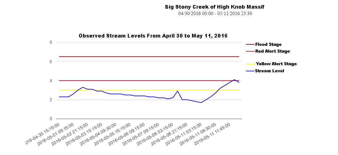
Big Stony Creek of High Knob Massif – May 2016
A vertical stream level rise of 2.4 feet generated roaring whitewater on Big Stony Creek ( draining 41.9 square miles of the High Knob Massif into northern Scott County ). This was the highest stream level observed so far in May. Strong rises, to gushing levels, were also observed on South Fork of the Powell River ( draining Big Cherry Lake Basin ) and on other steep creeks such as Clear Creek and the Little Stony along either side of the Wise County-Scott County border.
Head of Powell Valley and Grindstone Ridge of High Knob Massif
The heaviest rains fell above the great band of calcareous cliffs that ring much of the High Knob Massif, above which early-mid spring conditions currently exist verses late spring in valleys resting far below.
The focus during this early overnight of Thursday is once again on another batch of showers and downpours in thunderstorms moving across Kentucky.
As of 1:50 AM Thursday they are just beginning to develop into the mountains, in hit-miss fashion, along the High Knob Landform & Cumberland Mountains.
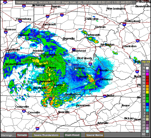
JKL Doppler At 1:50 AM Thursday – May 12, 2016
Short range models are struggling to capture this activity so uncertainty exists as to how much will make it into the mountains overnight into early Thursday. Since forecast models generally under-estimated rainfall amounts into early Wednesday, the potential for more downpours must be respected. Places that had heavy rain into Wednesday will be most likely to have strong rises on streams ( since the ground is already saturated ) if they have downpours.
Storm Prediction Center Risk RegionsSPC Discussion
Stay tuned to NOAA Weather Radio for any possible watches or warnings that might be needed.
ALERT For Downpours Of Heavy Rain During The Predawn-Early Morning Hours Of Wednesday
The Storm Prediction Center Has A Marginal Risk Of Severe Thunderstorms Across The Entire Region For Wednesday and Thursday
An Upgrade To A Higher Level Of Risk Will Be Possible For Portions Of The Region. Stay Tuned For Updates.
Overnight Into Tuesday Morning
Mostly cloudy. Mild. Chance of a rain shower. SSE-SSW winds 5-10 mph, with some higher gusts, along mountain ridges & plateaus below 2700 feet. SSW-SW winds 5-15 mph, with higher gusts, along mountain ridges above 2700 feet. Temperatures widespread in the 50s to low-mid 60s.
Tuesday Afternoon
Partly-mostly cloudy. Chance of showers & thunderstorms. Some storms could be strong to locally severe, especially late. S to SW winds 5-15 mph, with higher gusts. Temps varying from 60s in upper elevations to mid-upper 70s.
Overnight Into Wednesday Morning
Showers & thunderstorms. Some storms could be strong to locally severe. Downpours of heavy rainfall likely. SSW-SW winds 5 to 15 mph, with higher gusts, along mountain ridges-plateaus below 2700 feet. SW winds 10-20 mph, with higher gusts, along mountain ridges above 2700 feet. Mild with temperatures in the 50s to lower-middle 60s.
At least a marginal risk for strong to locally severe thunderstorms will continue Wednesday and Thursday, amid many dry hours. Remain alert for the potential of strong-severe thunderstorm development.
Wednesday Afternoon
Warm & humid. A chance of showers & thunderstorms. Winds SW-W at 5-15 mph. Temperatures varying from the 60s to around 70 degrees in upper elevations to the upper 70s to lower 80s.
Wednesday Night Into Thursday Morning
A chance of showers & thunderstorms. Winds SW-WSW 5-15 mph along mountain ridges-plateaus below 2700 feet. WSW to WNW winds 5-15 mph, with higher gusts, along mountain ridges above 2700 feet. Temperatures in the 50s to low-mid 60s.
Thursday Afternoon-Evening
A chance of showers & thunderstorms. Some storms could be strong to locally severe. Warm & humid. S-SW winds mainly under 10 mph ( outside of storms ). Temperatures varying from upper 60s to lower 70s in upper elevations to the upper 70s to lower 80s ( warmest at lower elevations in the Russell Fork-Levisa Fork basins ).
Weather Discussion ( May 8-12 )
Tuesday Evening Update
A very active afternoon-early evening to the west of the mountains has resulted in Severe Thunderstorm Watch Number 163 being issued up to the Virginia-Kentucky line.
Severe Thunderstorm Watch In Effect To 2:00 AM Wednesday – May 11, 2016SPC Severe Thunderstorm Watch Discussion
A line of thunderstorms is likely to impact counties along the Virginia-Kentucky border after midnight, except for northern portions of Dickenson-Buchanan counties where severe thunderstorms are possible earlier.
JKL Doppler At 10:08 PM Tuesday
Local development could occur in advance of such storms, as recently seen along and northeast of Pine Mountain ( with local development trying to get started in the High Knob Massif area ).
Regional Doppler Composite At 8:38 PM Tuesday – May 10, 2016
A total of 1.11″ of rain was recorded at the Upper Norton Reservoir with downpours associated with late evening thunderstorms that moved northeast across Powell Valley into the High Knob Massif during late Tuesday evening.
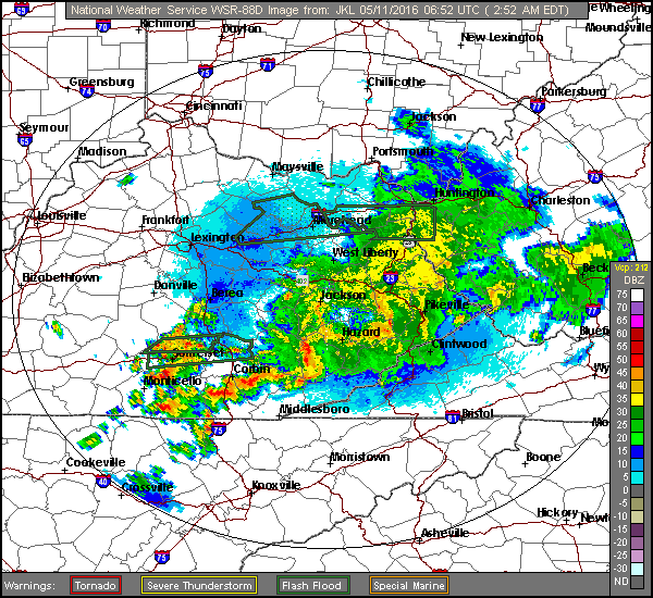
As of 2:00 AM Wednesday a non-severe line of thunderstorms, with heavy rainfall, was moving east across SE Kentucky and will impact the Cumberland Mountains overnight into Wednesday AM. Although downpours of heavy rainfall and lightning will remain most prominent, kinks ( bows ) in the approaching line continue to suggest localized strong-gusty winds will remain possible.
JKL Doppler At 2:52 AM Wednesday – May 11, 2016
Stay tuned to NOAA Weather Radio for possible additional watches and/or warnings which may be needed through Wednesday-Thursday.
Previous Discussion
Partly to mostly cloudy skies, with a little cooler temps, were observed on Mother’s Day which became better as the day progressed.
Late Spring Beauty In Powell Valley of High Knob Massif ( May 8 )
May 2016 has been wet, relative to March-April, with a stormy pattern expected to continue through much of this week before a break by late week into the early weekend gives way to another stormy period into next week.
*Cooler conditions are expected Friday-Saturday as a boundary stalls to the south, with return flow expected to then renew the threat for showers & thunderstorms by late weekend-early next week ( with a heavy rainfall potential ). Stay tuned for updates.
Storm Prediction Center Risk Regions To 8 AM Wednesday
The main focus Tuesday-Tuesday night will be on the potential for strong to severe thunderstorm development.
The SPC has expanded a slight risk region up against the western slopes of the Cumberland Mountains, with a noted potential for an upgrade to part of this slight risk region, to enhanced status, being possible by later Tuesday.
SPC Risk Of A Tornado Within 25 Miles Of A Given PointSPC Probability Of Damaging Winds Within 25 Miles Of A Given PointSPC Probability Of Damaging Hail Within 25 Miles Of A Given PointSPC Discussion For Tuesday into Tuesday Night
Rounds of showers and thunderstorms, some strong to locally severe, will remain possible Wednesday & Thursday in advance of a upper air trough and surface cold front.
Storm Prediction Center DAY 2 Risk Regions ( To 8 AM Thursday )
It is likely that the most favorable period for strong-severe thunderstorms during this mid-week time frame will come on Thursday as the surface front and trough approach from the west. Stay tuned for updates on this potential.
NAM 12 KM Model Total Rainfall Forecast Up To 8 AM Friday ( May 13 )
The NAM and GFS models illustrate how problematic it is trying to forecast rainfall at this time of year, with highly varied amounts over only short distances ( as the models guess where these MAXS and MINS will be, note that the key word being GUESS ).
GFS Model Total Rainfall Forecast Up To 8 AM Friday ( May 13 )
If the late week cold front stalls south of the mountain area, as currently suggested by the European Model group, then the potential for a heavy to excessive rainfall event may arise by next week ( with rainfall this week becoming a factor in the ultimate risk ).
*During May 1-9 more rain has fallen in Clintwood ( 2.43″ ) than fell during all of March ( 1.54″ ) or April ( 2.11″ ). It seems likely May will soon produce more rain than March-April combined.
Superintendent Gary Hampton, of the Big Stone Gap WP, reported the greatest April rainfall in the area with 4.64″ measured at the Big Cherry Lake Dam in the High Knob Massif ( 6.82″ during March-April and 22.28″ during January 1-April 30 ).
The Storm Prediction Center Has Issued A Marginal Risk For Severe Thunderstorms Later Today-Tonight For Locations Along & North To Northwest Of The Cumberland Mountains
Overnight Into Saturday Morning
Partly cloudy. WNW-NW winds 5-10 mph, with higher gusts, along mountain ridges and plateaus below 2700 feet. Winds WNW-N 10-15 mph, with higher gusts, on mountain ridges above 2700 ft. Temperatures in the 40s to around 50 degrees, except dropping into the 30s in colder mountain valleys ( especially along and north of High Knob Massif ).
Saturday Afternoon
Partly cloudy & warmer. Chance of a hit-miss shower or thunderstorm. Becoming gusty. WSW-W winds 10-20 mph with higher gusts. Temperatures varying from 60s in upper elevations to the mid-upper 70s to around 80 degrees.
Saturday Night Into Sunday Morning
A chance for showers & thunderstorms. Some storms could be strong to locally severe ( prolific lightning & damaging winds being the greatest threats ). W-NW winds 10-20 mph, with higher gusts, along mid-upper elevation mountain ridges-plateaus. Temperatures widespread in the 50s.
Sunday Afternoon
Partly to mostly cloudy. Chance of a hit-miss shower or thunderstorm. NW winds 5-10 mph, decreasing late and becoming variable to Easterly. Temperatures varying from the 60s to the lower-middle 70s.
Sunday Night Into Monday Morning
Partly to mostly cloudy. Winds becoming SSW-SW at 5-15 mph along middle elevation ridges-plateaus. Winds SW-W 10-20 mph, with higher gusts, along upper elevation ridges. Temperatures varying from the 40s to lower 50s in valleys to the 50s to lower 60s across exposed mid-upper elevation mountain ridges & plateaus.
A rather active and stormy pattern looks to dominate much of next week, with occasional rounds of showers & thunderstorms.
Weather Discussion ( May 6-9 )
From cold and blustery weather the pattern is now shifting back into late spring mode with warmer air poised to spread across the mountain region this weekend.
*The greatest snowfall reports during recent days featured 3.7″ on Mount LeConte and 3.5″ in Mount Mitchell State Park, both sites being above 6000 feet. A total of 3.0″ was reported on Beech Mountain. Only a trace of snow occurred atop the typically snowy locations of the High Knob Massif and Snowshoe Mountain ( at 4850 feet ). The coldest air aloft passing south across the Great Smokies and southern Blue Ridge.
Red Peony ( Paeonia spp. ) In Bloom – May 6, 2016
The focus now shifts back to May flowers & showers, with the Storm Prediction Center recently including much of southwestern Virginia within a marginal risk for severe thunderstorm development from late today into Sunday morning ( with WNW to ESE storm motion ).
Storm Prediction Center Risk Regions Up To 8 AM Sunday MorningStorm Prediction Center Discussion
This is in basic agreement with the latest European Model forecast, with higher storm chances from central-northern Wise County across Dickenson-Buchanan counties than across Scott & Lee counties.
NAM 12 KM Model Total Rainfall Forecast Up To 8 AM Sunday ( May 8 )
The NAM Model group is a bit farther southwest, but clearly also shows a bias toward better coverage-chances toward the northeast verses southwest in far southwest Virginia.
NAM 4 KM Model Total Rainfall Forecast Up To 8 AM Sunday ( May 8 )
Thunderstorms look to develop over western and central Kentucky during Saturday afternoon, and to spread east to southeast Saturday night into Sunday morning. It will be a very close call for this year’s Kentucky Derby, as to whether storms will impact the race or not.
While mean storm trajectories, via the mean flow field, will favor a E to ESE motion, outflow boundaries that interact with terrain features across central-eastern Kentucky could allow for storm development to build SE-S ( with new development often favored on the inflow side ).
Thus, all of the VA-KY border counties will need to be alert for the possibility of thunderstorms impacting any given location ( as well as parts of northeastern-eastern TN ).
As always, stay tuned to NOAA Weather Radio for any possible watches and/or warnings that may be needed from late Saturday Into Saturday Night-Sunday AM.