While much dry time is expected, any shower or thunderstorm developing through this Memorial Day Holiday could contain locally heavy rainfall and always dangerous lightning.
Overnight Into Saturday Morning
Partly to mostly clear. Areas of dense fog ( especially in places that had rain on May 27 ). Winds SSE-SSW 5-10 mph, with higher gusts, along middle elevation mountain ridges and plateaus below 2700 feet. Winds S-SW 5-10 mph, with higher gusts, on mountain ridges above 2700 feet. Temps in the 50s to lower-middle 60s ( coolest in mountain valleys at middle-upper elevations ).
Saturday Afternoon
Partly cloudy and unseasonably warm. Chance of a hit-miss shower or thunderstorm. Light SSE-SSW winds at generally less than 10 mph. Temperatures varying from low-mid 70s in upper elevations to the lower-middle 80s ( upper 80s possible in lower elevations that have more sunshine ).
Saturday Night Into Sunday Morning
Partly-mostly cloudy. Chance of showers & thunderstorms. Light & variable winds ( outside any storms ). Warm with temperatures widespread in the upper 50s to upper 60s.
Sunday Afternoon
Chance of hit-miss showers and thunderstorms; otherwise, partly cloudy and warm. Light winds becoming WNW-NW at generally 10 mph or less. Temperatures varying from low 70s at highest elevations to the upper 70s to mid 80s.
Sunday Night Into Memorial Day Morning
Partly to mostly clear. Areas of fog. WNW winds 5-10 mph, with higher gusts, along middle-upper elevation mountain ridges ( especially above 2500-3000 feet ). Temperatures in the 50s to lower 60s ( coolest in mountain valleys ).
Memorial Day Afternoon
Partly cloudy. Chance of a hit-miss shower or thunderstorm. Winds WNW-NNW at 5-10 mph, with higher gusts, on middle-upper elevation mountain ridges-plateaus. Temperatures varying from low 70s at highest elevations to the upper 70s to low-mid 80s ( warmest at lower elevations to the south-southeast of the High Knob Massif-Tennessee Valley Divide ).
Weather Discussion ( May 27-30 )
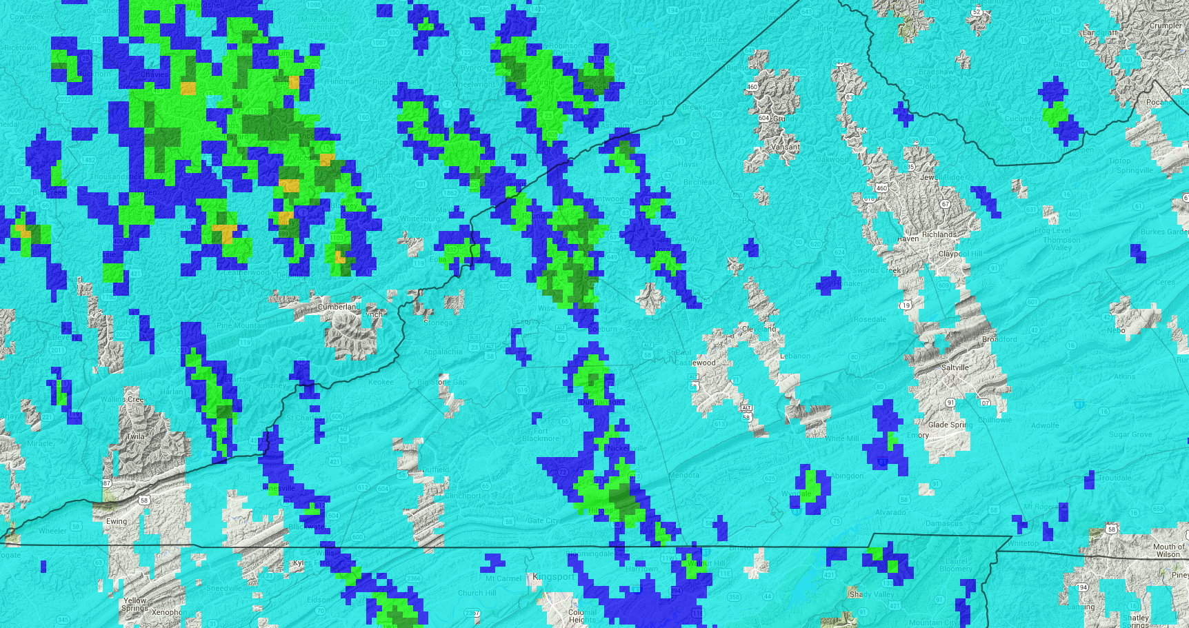
Hit-miss showers & thunderstorms, some with downpours of heavy rain and booming thunder ( dangerous lightning ) developed over the mountain area Friday afternoon.
The heaviest corridor of rain stretched from southeastern Scott County north across Wise County to the Wise-Dickenson border, and across portions of the southeastern Kentucky foothills.
Rain Drops Galore On A Spider Web – May 27, 2016
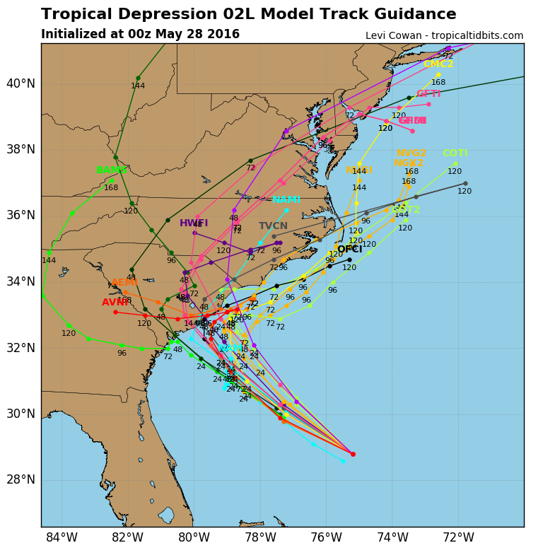
The second tropical cyclone of this season is expected to increase from Depression to Storm status before reaching the eastern Carolina’s during the Holiday Weekend.
Forecast Model Tracks For TD 2 – 8 PM May 27 Run
A Tropical Storm Warning is now in effect for the entire coastline of South Carolina, and may be extended into part of the North Carolina coast pending the exact track and strength of the system ( possible T.S. Bonnie ).
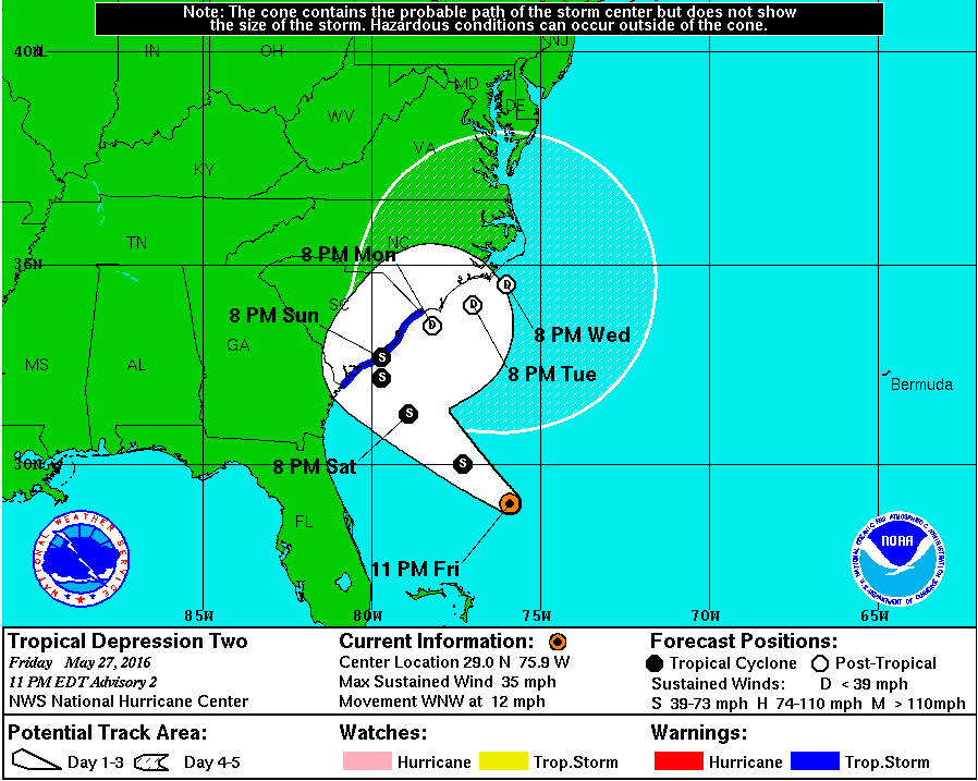
National Hurricane Center Official TrackNHC Discussion At 11:00 PM Friday – May 27, 2016
While the depression is still to cross the warm Gulf Stream, upper level shear will continue to hinder development beyond a low end Tropical Storm. Things can always change, but those are current indications based upon NOAA Hurricane Hunter data and forecast models. Heavy rainfall, with inland and coastal flooding, remains a concern and should be closely monitored by anyone with travel plans to central-eastern portions of the Carolina’s.
Pink Form of Common Yarrow ( Achillea millefolium )
Meanwhile, to the north and northwest the southern Appalachians are coming under the subsidence zone along the outer periphery of this developing tropical system.
USA Water Vapor At 1:15 AM on Saturday – May 28
Sinking air through mid-levels of the atmosphere is shown above by the circular shaped zone of clear ( dark ) air across much of Virginia and the eastern portion of Tennessee into Georgia.
Saturday is likely to be the hottest day of May 2016 with air sinking over the mountain area. This will be especially true for places that do not have convection or any significant cloud development during the afternoon.
While synoptic-scale subsidence will generally work against convective development during the daylight hours of Saturday, some local terrain forced activity can not be completely ruled out and must remain in the forecast. Chances increase again into Saturday Night and Sunday as the atmosphere becomes more conducive again for rising air ( the subsidence zone weakens for locations along and west of the Cumberland Mountains ).
Remember that any thunderstorm development through the Memorial Day Holiday could contain downpours of rain and always dangerous lightning. Stay safe and have a great Holiday Weekend-Monday.