A Crippling Fall of Very Heavy Snow, With Extreme Snowfall Rates Is High For Friday Morning Into Mid-Day
*Even the downslope wake zone of the High Knob Massif may have very heavy snowfall during this period
Please Do Not Travel If Possible
*My new forecast will be out after Midnight
ALERT For High Impact Winter Storm Development Friday With Potential For Crippling Snowfall Amounts And Possible Power Outages
Snowfall Forecast For January 22-24, 2016 Storm Event
Very strong LIFT ( Upward Vertical Motion ) will be moving across the region Friday. This has a chance of overwhelming downslope sinking-warming of air, and IF it should then heavy ( WET ) snow could develop in the Powell Valley-Big Stone Gap-Lee County and TRI areas to generate more snow than being predicted.
I will likely update my snowfall graphic tonight to include “higher amounts possible” for those subsidence zones in the Powell Valley-Big Stone Gap to Lee County corridor.
The European Model remains rock solid, with consecutive runs of the high-resolution NAM supporting its solution. A major fall of heavy snow is expected Friday in the Norton-Wise and adjacent high country of the High Knob Massif, with mixed precip types amid the Powell Valley-Big Stone Gap corridor extending into portions of southwestern Wise County and Lee County if the dynamic cooling and lift amid the atmosphere does not over-whelm warming with sinking in low-levels on ENE-ESE flow.
All locations will have snow Saturday-Saturday Night as cold air increases across the region on a deep NE-NW flow. This portion of the storm will have low density snow verses a higher density snow during the day Friday.
ALERT For Freezing Fog & Hazardous Walking-Driving Conditions Overnight Into This Morning ( Especially Dense Fog Along and North of the High Knob Massif )
Overnight Into Mid-Morning
Freezing drizzle or fine ( snizzle ) snow. Freezing fog at middle to upper elevations ( especially along and north of the High Knob Massif & Tennessee Valley Divide ). NW to NE winds at 5-15 mph. Temperatures varying from the 10s at highest elevations to the 20s. Wind chills in single digits and teens ( coldest at highest elevations ).
Mid-Morning Through This Afternoon
Decreasing low clouds. Some mid-high clouds possible. Winds NE-E at generally less than 10 mph. Temperatures varying from mid-upper 20s to low 30s ( mid-upper 30s+ only amid locations to the south toward the Tri-Cities ).
Tonight Into Friday Morning
Increasing clouds with snow developing into the predawn-morning. Mix ( sleet, freezing rain, or rain ) developing in Powell Valley to Big Stone Gap corridor. Winds ESE increasing to 5-10 mph below 2700 feet by morning. ESE-SE winds 10-15 mph, with higher gusts, along mountain ridges above 2700 feet. Temperatures generally in the upper 20s to lower 30s.
Weather Discussion ( January 20-21 )
Afternoon Update
This Update is to Heighten My ALERT for Major Winter Storm Development Into Early Friday As Enough Runs Have Now Been Seen To Have Increased Confidence In A High Impact Winter Storm Event.
Storm snowfall predictions from computer model runs on Thursday Morning for the Wise gridpoint vary from 9″ in on the American GFS Model to 14″ on the European Model to 19″ on the high-resolution NAM Model.
NAM 4 KM Model Total Snowfall ForecastGFS Model Total Snowfall Forecast
There is likely to be a huge snowfall gradient across the High Knob Massif area, with the high-resolution NAM trying to see it ( but not fully ).
Local View of NAM 4 KM Model Total Snowfall Forecast
Inversional conditions today, a result of banking of low clouds up against the High Knob Massif & Tennessee Valley Divide into early afternoon ( before finally breaking ), has kept temps above the snow colder in lower elevations with the 2:30 PM temp of 27.5 degrees at Clintwood 1 W being about the same as at the summit level of High Knob.
NASA Visible Satellite At Noon on Thursday
My Overnight Discussion
My forecast during this past day did not need to be updated as it worked out nicely. The main mistake was that I should have expanded my predicted 3″ to 6″+ snowfall zone along the High Knob Landform to include the TRI area due to the expected tendency for lower density snow.
Reference my 012016 Forecast discussion section for details.
*However, as noted on my main forecast page, this site is centered upon the High Knob Landform and Massif area ( e.g., Norton-Wise into Big Stone Gap and Lee-northern Scott counties ) and is not for the TRI area specifically ( where multiple TV & Radio stations, as well as the Morristown National Weather Service Forecast Office, are all located to cover the Great Valley of eastern Tennessee ).
High Knob Massif Webcam – University Of Virginia’s College At Wise
A period of mostly light morning snowfall was followed by heavier afternoon snow. Accumulations ended up being greatest from Lee County southwest toward Norris Lake, with up to 6.5″ of snow depth measured by Harold Jerrell just southeast of Rose Hill in western Lee County.
Northern Cardinals On Cedar Tree In Lee County – Snow Depth 6.5″
Veteran weather observer Denver Garrett measured 4.7″ in the Jonesville area of Lee County.
High Chaparral of High Knob Massif – January 20, 2016
A general 3″ to 5″ of new snow accumulated across the High Knob Massif where totals actually came in on the low end of the forecast range ( for a change ). Some blowing & drifting was noted amid the main crest zone surrounding the peak of High Knob during the afternoon.
Chris & Paxton Allgyer measured 3″ of snow depth in Big Stone Gap which was about the same as Darlene Fields in the High Chaparral community of the High Knob Massif ( that seldom occurs ).
High Knob Massif Webcam – University Of Virginia’s College At Wise
Between 2″ and 3″ of new snow fell in the Clintwood area with officially 3″ on the ground at my station just before sunset when some large snowflakes were falling ( later transitioning to a very fine drizzle-like snow that I call snizzle ).
Lonesome Pine Airport In Wise
Clouds bases have dropped into middle elevations along and north of the High Knob Massif tonight, with freezing drizzle and very fine, drizzle-like snow.
Focus now shifts toward a major winter storm event that is timed to begin into the predawn hours of Friday. Specific details such as the nature of the surface low track and the transfer of its energy to the Atlantic Coast will be critical and may not be resolved fully until later today.
Generalized European Model 51-Member Ensemble Mean Track
The European Model has remained extremely consistent in taking a surface low from Louisiana into northern Alabama before a rapid transfer & reformation over South Carolina by late Friday. Such a track would keep colder air in place over the area and allow for more snowfall.
The NAM & GFS Models ( especially GFS Model ) allow more warm air to work up along the western slopes of the Appalachians via more downsloping along the TN-NC border.
The new European run tonight continues to be consistent with the above Ensembles track and predicts 14″ of snow to fall at the Wise gridpoint during this storm event ( 10″ of that falling between the predawn to 7:00 PM of Friday ).
*If the above verified, snowfall would be greater since the comma-head snow amid the backside, NW-NE upslope flow period, would have a lower density and produce more snow than the model says.
NAM 4 KM Model Total Snowfall Forecast Next 60-Hrs ( 1 AM Run on Jan 21 )
This high-resolution NAM 4 KM Model run is very interesting in that it shows the deformation zone band very well across KY into the HTS-CRW region of West Virginia and is also trying to capture the downslope and sinking amid the wake zone of the Cumberland Mountains with respect to easterly air flow trajectories.
The model is just not able to fully resolve that immediately amid and adjacent to the High Knob Massif where a TIM Circulation forms to greatly enhance precipitation amounts ( i.e., snow amid the high country and mix in the wake zone with subsidence ).
NAM 4 KM Model Total Snowfall Forecast Next 60-Hours
The latest high-resolution NAM 4 KM Model has duplicated the European Model solution with 14″ also being predicted for the Wise gridpoint through 60-hours ( some more falls beyond this time on N-NW upslope flow ).
This type of flow field would generate a TIM Circulation across the High Knob Massif with a very large snowfall gradient setting up along and downstream of the massif amid its wake zone with respect to ENE-ESE air flow.
A featured I’ve documented numerous times since the infamous January 1998 episode that unofficially set a new 24-hour snowfall record for the Old Dominion when 36″ to 40″+ of snow accumulated amid upper elevations of the High Knob Massif in only 21-hours.
A Miller A Inland Variant Track – Single Low Tracks Far To South & East
The January 1998 and December 2009 events, which crippled the mountain area with power outages & snow depth, were Miller A cyclones ( inland variants ).
This event is not a classic Miller A, and does have a Miller B tendency which tends to reduce snowfall along the western slopes of the southern Appalachians ( and at times across all of the southern Appalachians ).
Miller B Climatology – A Double Low With Transfer of Energy To Coast
So the key to this forecast setting will be how much it favors Miller B verses Miller A ( to make it simple ) from a climatological perspective.
The European Model’s consistent solution of not bringing a surface low north of the southern Tennessee – SW North Carolina area will keep colder air across southwestern Virginia and generate more total snowfall verses a surface low that moves farther northeast up the Tennessee Valley before transfer of energy to the Coast.
*The huge snowfall gradient that I have on my forecast snow graphic at the beginning of this page would hold in the ECMWF solution. If the solution goes more toward classic Miller B; however, amounts would be reduced significantly at all sites.
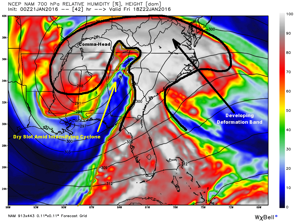
Dry Slot of Intensifying Cyclone – NAM Model Forecast At 1 PM Friday
Another critical difference between the European and American models, as well, is the 700 MB dry slot that works into the area during the formation of a large comma-head and deformation zone. The dry slot is a little longer lived and more pronounced on the American models than it is on the European over this area ( where it is a brief intrusion that rapidly gets advected off toward the east ).
NAM 12 KM Model Total Snowfall Forecast
Even with the dry slot ending precipitation for a time late Friday, the NAM Model still predicts more than a foot of snow across the Cumberland Mountains ( missing fine details of the terrain ).
There are multiple mechanisms at work in this event:
1 ). Isentropic Lifting
( Warm Conveyor Belt )
2 ). Orographic Forcing
( Mesoscale Features )
3 ). Dry Slot Formation
( Signal of Intensifying Cyclone )
3 ). Deformation Zone
( Enhanced Lifting )
4 ). Comma-Head N-NW Flow
( Cold Conveyor Belt )
These and other features look to phase best from the central Virginia-West Virginia border area northeast into northern Virginia and portions of adjoining states. However, the local potential remains very significant as I have well documented within past climatology.
Needless to say, this storm has huge potential and my next forecast will be critical as by then it should be known if the European solution is going to verify.
Since today is the last day we have to prepare, please do anything necessary to keep you and your family safe during a potentially major event that could include power outages and deep snow depths.