ALERT For Accumulating Snow Tonight Into Thursday Morning With Bitterly Cold Temperatures-Wind Chills During Tuesday Into Thursday. This Pattern Is Likely To Continue Through This Weekend Into Next Week To Mark A Harsh Period Of Winter In The Appalachians.
Snow covered & hazardous road conditions will continue and worsen overnight into Tuesday morning as temps drop. Travel is not recommended unless absolutely necessary. Please use extreme caution if traveling overnight.
Overnight Into Tuesday Morning
Light snow, snow showers & bursts of heavy snow. Turning bitter into morning. W-WNW winds 5-15 mph, with higher gusts, at elevations below 2700 feet. Winds W-NW 10-20 mph, with higher gusts, upper elevation mountain ridges. Blowing & drifting snow at high elevations. Temperatures dropping into low 10s at highest elevations and into upper 10s to lower-middle 20s at lower-middle elevations ( near 10 degrees at the summit of High Knob Massif ). Wind chills dropping into single digits & 10s, except 0 to -15 below zero across upper elevations in the High Knob Massif & Black Mountain. Extensive rime formation at high elevations.
This Afternoon
Light snow & snow showers. Local bursts of heavier snow. Cold. Winds W to NW at 5-15 mph, with higher gusts, along middle-upper elevation mountain ridges-plateaus ( blowing & drifting snow at exposed middle-high elevations, riming at high elevations ). Temperatures varying from 10s above 3000 feet to lower-middle 20s ( milder in the Clinch, Powell, Holston river valleys toward the Tri-Cities ). Wind chills in the single digits and 10s, with sub-zero values in gusts along high mountain crestlines.
Tonight Into Wednesday Morning
Snow & snow showers. Local bursts of heavier snow. Bitter. Winds W to NW at 5-15 mph, with higher gusts, along mid-upper elevation mountain ridges & plateaus. Blowing and drifting snow with riming at high elevations. Temps from single digits at highest elevations to the 10s in Norton-Wise ( milder in lower elevations toward the Tri-Cities ). Wind chills in single digits above & below zero ( coldest at high elevations, with WCF’s as low as -10 to -15 below zero ).
New Snowfall – Tonight Thru Wednesday
A general 4″ to 8″+ along upslope side of mountains
( Target storm snowfall total of 8″ in Norton-Wise )
1″ to 4″ on downslope side of mountains
Target storm snowfall total ( for entire event ) remains at 8″ for Norton-Wise ( +/- ) 2″ to imply a potential for 6″ to 10″ . A general 2″ to 3″ had accumulated up to Midnight on Feb 8 in Norton-Wise.
Target storm snowfall total ( for entire event ) is 8″ to 14″+ for upper elevations in the High Knob Massif. A general 5″ to 6″ had fallen up to Midnight on February 8 at elevations above 3200 ft.
Snow depths at any given time, outside of drifting, are expected to be less than total snowfall by 1-3″ due to melting-sublimation and settlement over time during this prolonged event.
Storm total extremes are expected to vary from more than 12″ amid highest elevations in the High Knob Massif to 3″ or less in portions of the Tennessee Valley ( downslope of mountains ).
This snowfall will occur over a prolonged period of time and generally be of low to very low density ( fluffy ). This tends to enhance settlement over time as snow depth increases. Note storm snowfall totals are between Monday AM and Thursday AM ( i.e., snowfall totals by Thursday Morning are currently projected to reach forecast storm total values ).
A prolonged rime event is expected for upper elevations, above 3300 feet, in the sprawling High Knob Massif where significant accumulations are likely during the next few days.
Weather Discussion ( February 8-9 )
My Afternoon Update
As of 9:00 AM, Superintendent Andrew Greear and Caleb Ramsey reported that total snowfall had reached 5.6″ at the City of Norton Water Plant ( 1.5″ of new snow accumulated during the 4:00 to 9:00 AM period ).
The official 8″-diameter National Weather Service rain gauge total reached 0.37″ for the water content on 5.6″ of snow, making for a 15:1 density ( snow to water ratio ) at the City of Norton WP.
3:00 PM Update: Caleb Ramsey reported only 0.7″ of new snow at the Norton Water Plant at 3 PM. This makes an event total of 6.3″ ( 6″ currently on the ground ).
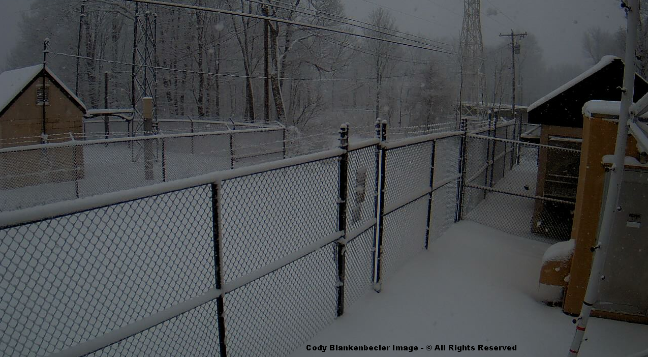
Cody Blankenbecler reported 4″ of snow depth on East Park Avenue in downtown Norton, where some snow has melted, of course, along the pavement ( just after 4:30 PM ).
High above, on Eagle Knob of the High Knob Massif, around 2.0″ of new snow has accumulated to bring the storm tally to 13.0″ ( with moderate-heavy snow during the past hour ).
Deep Snow In High Chaparral of High Knob Massif at 4:00 PM on February 9, 2016
Joe & Darlene Fields confirm the new snowfall with 2.0″ of new snow reported in High Chaparral, to bring the storm tally to 10.2″ at their home ( elevation 3300 feet ) at 4 PM.
High Knob Massif Webcam – University Of Virginia’s College At Wise
There have been some significant snow depth variations around Wise due to ground temperatures and wind in combination with this low density snow ( note I had anticipated that and have had it in my forecast during the past couple of days ). The most snow being held on colder, north slopes and more sheltered locations.
At 9:30 AM, Joe & Darlene Fields reported a snowfall total of 8.2″ in High Chaparral of the High Knob Massif ( including 1″ which fell and melted during the day yesterday ).
Eagle Knob of High Knob Massif at 2:35 PM – February 9, 2016
The air temp on Eagle Knob has been hovering around 9 degrees this afternoon, with wind chill factors as low as -10 below zero at times in gusts on NW winds. Snow is falling steadily and cloud bases have temporarily lifted off the summit to reveal extensive riming of trees.
At around the same time ( 9-10 AM ), the snowfall total on Eagle Knob of the High Knob Massif reached approximately 11.0″, with more than a foot of snow depth in many places.
By rather dramatic contrast, Chris Allgyer measured only 0.5″ on his deck in Big Stone Gap at 9:00 AM this morning.
Likewise, lee of the massif, in The Pines area of the Clinch River Valley near Dungannon, Anna Hess reported only 0.8″ of snow depth this morning.
To the north, here in Clintwood, I’d had 3.0″ of snowfall with a mean depth of 2″ on the ground.
My Overnight Discussion
As of Midnight, and the beginning of another day, snow depth reports varied from 1-2″ in Clintwood to around 3″ across Norton-Wise and 5″ to 6″+ amid upper elevations of the High Knob Massif ( above 3000 feet ).
4:00 AM Update: Scott Craft measured 1.9″ of new snow at the City of Norton Water Plant ( fell during 10 PM to 4 AM period ). This makes a storm snowfall total of 4.1″ and a depth of 4″ at the northern base of the High Knob Massif.
Scott Craft measured 2.2″ up to 10:00 PM on February 8.
Simply gorgeous scenes were captured around sunset.
High Knob Massif Webcam – University Of Virginia’s College At WiseHigh Knob Massif Webcam – University Of Virginia’s College At WiseHigh Knob Massif Webcam – University Of Virginia’s College At Wise
The evening featured continuous snow with intervals of moderate to heavy snow. Darlene Fields shows large flakes falling furiously in High Chaparral around 9:30 PM.
Snow Falling In High Chaparral of High Knob Massif at 9:28 PM ( Feb 8 )
Roads in Wise became covered by around 11:00 PM.
High Knob Massif Webcam – University Of Virginia’s College At Wise
Temperatures have been dropping with 10s across highest elevations ( wind chills around 0 degrees in gusts ).
Black Mountain MesoNET Up To 1:15 AM – February 9 ( Elevation 4031 feet )
There was some interest in thundersnow Monday. When I was outside taking these photographs I heard a rumble that certainly sounded like thunder ( falling snow muffles sound waves and unless the thundersnow is close by it is difficult to hear from a distance ). I have documented thundersnow many times in the High Knob Massif area.
Convective Snow Burst In Clintwood at 2:56 PM – February 8, 2016
There are several different ways, of course, to photograph snow falling. One can set the shutter speed slow and have it silk out into streaks or set it fast to stop motion. You can also set it intermediately, as I did above, for a little of both affects.
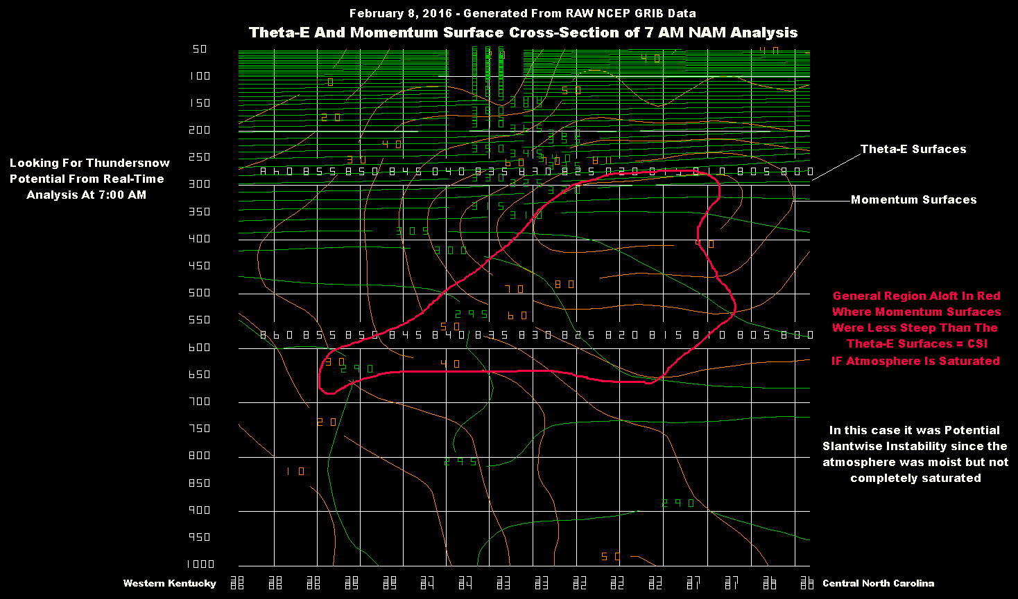
Theta-E & Momentum Surface Cross-Section At 7 AM – February 8, 2016
The above cross-section is taken along a line through the High Knob Massif area, from near the Ohio River in western Kentucky into central portions of North Carolina ( eastward of the Appalachians ). Ideally, these cross sections should be taken perpendicular to the Thermal Wind in the mid troposphere, which I did approximately here since the 700-500 MB flow field was SW in nature early this morning ( the cross-section WNW-ESE ).
I have to first give credit to the late Dr. James T. Moore of Saint Louis University for teaching me about thundersnow following a major local event during March 1995 ( up to 15″ of snow depth accumulated atop the High Knob Massif in a prolonged thundersnow event that lasted for hours ).
Dr. Moore was the king of Isentropic Analysis and a very kind man. He was a true teacher and contributed greatly to the advance of meteorological science.
The March 8, 1995 setting was much different from today but the principles are the same. Conditional Symmetric Instability ( CSI ) is what one is looking for as during most thundersnow events clouds are not vertical. The air mass may, in fact, be stable with respect to vertical ascent but is unstable with respect to slantwise motion. Cloud tops may be less than 20,000 vertical feet tall but the convection can reach up to 40,000+ feet in a tilted or slantwise direction.
Such slantwise convective requires the slope of Momentum Surfaces ( which I have plotted above in brown ) to be more shallow ( less steep ) than the slope of Equivalent Potential Temperature ( called Theta-E ) Surfaces ( which I have in a green color above for the 7 AM Analysis on February 8 ).
The atmospheric state this morning featured a relatively large region with Potential Symmetric Instability since the air mass was not saturated within the layers in which I have roughly outlined ( in red ) where the requirements for CSI were present. With forced lifting to saturation this state could have been converted into CSI, and ended up being in places with good lifting during the afternoon. CSI is strictly defined only in a saturated environment with a lapse rate that is nearly moist-adiabatic in nature.
Approximately in the middle of the cross-section is an area where Theta-E decreases with height to indicate convective instability. CSI & Convective Instability can co-exist, but the upright convection will typically dominate.
Focus during this 36-hour forecast cycle by short-range models are wanting to place the emphasis for heaviest snow across southern Ohio.
NAM 4 KM Model Total Snowfall Forecast To 7 AM Wednesday – 7 PM Run
With abundant 700 MB moisture, cyclonic flow, and cold air advection into the mountains on W-NW flow it is difficult to not accumulate snow, at least at middle-upper elevations.
*Any time air is this cold aloft a RH of 70% or greater at 700 MB is significant, especially amid cyclonic flow. It will be surprising if the upcoming day is void of snow showers and local squalls along the mountains.
NAM 4 KM Model Total Snowfall Forecast To 7 AM Wednesday – 1 AM Run
All models have already greatly under-estimated snowfall in the High Knob Massif & Norton-Wise area up to this point in time, and are very likely also under-estimating snowfall through Wednesday. So for now, I have kept my original snow forecast numbers ( which are to Thursday AM ), and can update later today or tonight if needed.
While many always are interested in snow, the real deal upcoming is bitter cold that will intensify today into Wednesday ( temperatures during the daylight hours of Wednesday will struggle in the 10s in Wise and Norton ). Longer days will help some, but this air mass and the next one upcoming by this weekend are of true arctic origin. The actual Polar Vortex will be stretched enough to push the most bitter air of the entire winter season into the area by late Friday into Saturday ( followed by a potentially heavy snow ).
ALERT For Accumulating Snow Today Into Thursday Morning With Bitterly Cold Temperatures-Wind Chills During Tuesday Into Thursday. This Pattern Is Likely To Continue Through This Weekend Into Next Week To Mark A Harsh Period Of Winter In The Appalachians.
Although No Official Winter Storm Warning Has Been Issued For Wise County by MRX, Let There Be No Doubt That Conditions Tonight Into Tuesday Will Be Just As Bad Or Worse Than In Any Of The Tennessee Mountain Counties, That Currently Are Under A Warning, Amid The Norton-Wise & High Knob Massif Area
New high-resolution model runs are playing down the AM snow, via dry low-levels, despite a healthy looking Doppler to the west. As noted in my weather discussion, models will struggle in this type of pattern on daily details.
A break in activity will be possible behind any morning snow before new development begins Monday afternoon. Due to very cold air aloft, bursts of heavy snow ( amid general snowfall ) will be capable of producing whiteout conditions at times from this afternoon into Tuesday-Wednesday. Increasingly bad conditions are expected as air turns bitterly cold Tuesday & Wednesday, with the worst conditions likely to develop along W-NW facing slopes and interior crests of the High Knob Massif & Black Mountain.
Overnight Into Mid-Morning
Increasing clouds into morning with a chance for a period of snow. SSW to SW winds 5-15 mph, with higher gusts, along middle elevation ridges & plateaus below 2700 feet. SW to WSW winds increasing to 10-20 mph, with higher gusts, along upper elevation mountain ridges above 2700 feet. Temperatures mostly in the 20s to lower 30s. Wind chills in the 10s & 20s ( coldest highest elevations ).
Mid-Morning Through Monday Afternoon
Any AM snow giving way to a break. Then snow showers and snow squalls developing during the afternoon ( possible mixture at lower elevations, especially Russell Fork & Levisa Fork basins ). SW winds shifting W at 5-15 mph, with higher gusts along mid-upper elevation ridges & plateaus. Temps varying from 20s at highest elevations to the mid-upper 30s. Wind chills in the 10s & 20s across upper elevations.
Tonight Into Tuesday Morning
Light snow, snow showers & bursts of heavy snow. Turning bitter into morning. W-WNW winds 10-20 mph, with higher gusts, on mid-upper elevation mountain ridges & plateaus. Temps dropping into low 10s at highest elevations and into upper 10s to low-mid 20s at lower-middle elevations. Wind chills dropping into single digits & 10s, except 0 to -10 below zero at highest elevations in the High Knob Massif & Black Mountain. Extensive rime formation at highest elevations.
Snowfall Forecast – Monday Through Thursday AM
A general 6″ to 12″+ along upslope side of mountains
3″ to 6″ on downslope side of mountains
Target snowfall of 8″ in Norton-Wise ( +/- ) 2″ Error Potential. This implies a potential for 6″ to 10″ of snowfall. Snow depths at any given time, outside of drifting, are expected to be less than total snowfall by 1-3″ due to melting-sublimation-settlement.
Extreme snowfall totals are expected to vary from more than 12″ amid highest elevations in the High Knob Massif to 3″ or less in portions of the Tennessee Valley ( downslope of mountains ).
This snowfall will occur over a prolonged period of time and generally be of low to very low density ( fluffy ). This tends to enhance settlement over time as snow depth increases. Note snowfall totals are between Monday AM and Thursday AM ( i.e., snowfall totals by Thursday Morning are currently projected to reach forecast values ).
A prolonged rime event is expected for upper elevations, above 3300 feet, in the sprawling High Knob Massif where significant accumulations are likely during the next few days.
Stay tuned for updates on this preliminary forecast.
Weather Discussion ( February 8 )
My Afternoon Update
New model runs into the overnight were correct in playing down the morning snow, with no more than flurries as low level air remained dry.
High Knob Massif Webcam – University Of Virginia’s College At Wise
No more than a dusting was on the ground atop the High Knob Massif at early afternoon. That would soon change!
High Knob Massif Webcam – University Of Virginia’s College At Wise
Whiteout conditions developed in the Norton-Wise, Sandy Ridge and High Knob Massif area amid wind driven snow.
High Knob Massif Webcam – University of Virginia’s College At Wise
The mountain landscape was quickly transformed into a wintry wonderland, but at the price of catching motorists who had not kept up with my forecast of blinding snow squalls off-guard.
High Knob Massif Webcam – University Of Virginia’s College At Wise
This snow covered middle-upper elevations above 2000 feet, with sticking and melting to the northeast in lower elevations of the Russell Fork Basin ( Pound-Clintwood ).
Nora 4 SSE – Official NWS Observation Site ( Elevation 2650 feet )
Temperatures which spiked to 40 degrees amid the “break” into mid-day have now quickly dropped below freezing at all elevations above 2000 feet along and north of the High Knob Massif ( low 20s atop High Knob, with NW wind gusts to 30 mph generating WCFs down to around 5 degrees above zero at 4:00 PM amid riming ).
Regional Doppler At 4:18 PM on Monday – February 8, 2016
Focus now shifts to new convective bursts developing beneath bitterly cold air aloft to the west, with conditions expected to become extremely bad across the mountain area this evening into the overnight period in advance of a very compact vorticity max and excellent divergence ( diffluence of isobaric contours ) aloft ( the echoes across middle KY & middle TN will tend to intensify along the Cumberlands ).
NAM Model 500 MB Vorticity Forecast – 1:00 AM Tuesday ( February 9, 2016 )
Low-level temperatures will be dropping to enhance the bad conditions expected tonight into Tuesday morning. Caution is advised for anyone planning to travel during this time.
High Knob Massif Webcam – University Of Virginia’s College At Wise
Orographic pilatus clouds capping the high country of the High Knob Massif is a signal for enhanced snowfall ahead, via riming of snowflakes and increased volume of snow reaching the ground.
My Overnight Discussion
The main focus of this weather discussion is on a prolonged period of snowfall and increasingly cold air, starting today and continuing through this week into the weekend as a harsh period of winter settles into the Appalachians.
If my preliminary snowfall forecast numbers are not reached by Thursday morning, it is an excellent bet that they will be reached by Saturday afternoon ( February 13 ) as a strong reinforcing arctic blast brings more snow. In fact, this preliminary snowfall forecast may certainly be too low by the time all is said and done. Time will tell more and updates made as the actual weather pattern develops and new model data arrives in coming days. Stay tuned.
*The latest European 16 KM Model is forecasting a general 6″ to 16″ of snowfall ( at 10:1 density ) along upslope sides of the mountains between this morning and Saturday afternoon ( February 13 ).
NAM 4 KM Model Total Snowfall Forecast Next 60-Hours
Due to very cold air aloft, the high-resolution NAM Model continues to repeatedly show very heavy local amounts as the atmosphere becomes absolutely unstable by this PM into Tuesday. Placement of MAX amounts being varied on any given run, with the signal being most important to indicate intense bursts of snow ( whiteouts in blinding squalls ).
GFS Model Total Snowfall Forecast Next 84-Hours
The GFS Model forecasts a general 2″ to 11″ of snow along the upslope side of the Appalachians between this morning and Thursday morning ( again, at 10:1 snow density ).
GFS Model 5-DAY Snowfall Forecast
The GFS 5-day snowfall forecast is a general 6″ to 12″ along the upslope side of the Appalachians.
Regardless of how much snow falls, bitter cold air is going to become a major force in coming days with two distinct surges of arctic air into the Appalachians centered on the late Tuesday-Thursday period ( February 9-11 ) and the weekend ( Saturday-Sunday period of February 13-14 ).
The coldest temperatures will likely go sub-zero at some point during this period, and in the worst case scenario it would be possible that MAX temperatures in Norton-Wise will struggle to break above 0 degrees on the coldest day. This is the potential which the pattern possesses, and only a notice for what could occur. While this is not yet in my forecast, it has enough merit, given factors in my extended outlook and new model data, that it should be noted now to warn EMS personnel and residents well in advance. If this does not happen, then we have dodged a very bitter bullet.
European Ensembles 850 MB Forecast – 7 AM Saturday ( Feb 13 )
While the big picture of the pattern is relatively clear, details on any given day will be hard for models to fully resolve given the very cold air aloft and instability that develops vertically during the next few days.
A harsh period of winter weather is poised to strike the mountain region during the next 7-14 days. This has been well anticipated by large-scale changes amid the atmosphere across the Northern Hemisphere.
Temperatures above the North Pole at 10 MB have recently been at RECORD high ( warm ) levels for this time of year, having warmed dramatically from near record low ( cold ) values in late December and mid January.
Zonal Mean Temperatures 60-90N Latitude At 10 MB
Zonal Mean Temperatures in the 60-90 degree latitude range at 10 MB have also peaked at record high ( warm ) levels in recent days.
Geopotential Wave 1 Height Amplitude at 60 N and 10 MB
Record strong Wave 1 forcing has been responsible for the dramatically high stratospheric warming in upper levels.
Geopotential Wave 1 Height Amplitude at 60 N and 100 MB
Wave 1 forcing has been strong through the depth of the stratosphere ( near bottom level above ), but clearly has been strongest in upper levels of the stratosphere.
Wave 2 forcing has been weaker than average this winter.
European Model 10 MB Analysis – 7 AM February 7, 2016
A sense for what Wave 1 means can be gained by looking at the European Model’s 10 MB analysis ( above ) at 7 AM on February 7, with dramatic warming over Siberia associated with a single ridge and trough couplet ( High and Low at 10 MB in the Stratosphere ). Upward WAF ( Wave Activity Flux ) from extensive Siberian snow has helped to drive this event along with a favorable large-scale pattern that allows for co-location with the MEAN climatological standing wave pattern of the Northern Hemisphere winter-time, in addition to Torques driven by major mountain barriers.
European Model 10 MB Analysis – January 30, 2016
For comparison, above, I have the 10 MB analysis at 7 AM on January 30. Note that the TEMP MAX is listed at -22 C verses the TEMP MAX of +18 C on the previous 10 MB analysis for February 7. That is a 72 degree F ( 40 C ) increase in temperature in 9 days.
Zonal Mean Zonal Wind at 60 N and 10 MB
Despite dramatic high stratospheric warming, this event has not been able to yet reverse winds at 60 degrees North and 10 MB to meet the technical criteria for a major SSW event ( Sudden Stratospheric Warming ).
There is considerable debate about whether this technical definition for a major SSW event needs to be defined in different terms and/or expanded to also include additional scenarios like this event which has clearly had an important impact upon the Polar Vortex and Northern Hemispheric weather pattern.
European Model Zonal Mean Wind Forecast – 7 AM February 9
The European Model forecast is ever so close to meeting the technical definition, with easterly winds shown at 45 N and 10 MB as well as at 72-90 N and 10 MB but not at the defined 60 N and 10 MB required for the technical declaration of a MAJOR SSW event. So the debate continues.
GFS Ensembles Forecast of Arctic Oscillation
The Arctic Oscillation ( AO ) which has recently been in a positive phase is forecast to trend back negative for a long period of time. Past climatology, following SSW events, show that -AO periods of 4-6 weeks are not uncommon.
Despite the +ENSO in the Pacific, temperatures this winter have been strongly correlated to the phase of the AO.
Recent Arctic Oscillation Phase State & Forecasts
Note above how the AO was mostly in a positive phase from November to the start of January ( when we observed above average temperatures ), then shifted into a negative phase through most of January ( when it was cold ). Recently, the AO has been positive and temperatures have been mild. A very high temp correlation this winter to the AO phases.
GFS Ensembles Forecast of North Atlantic Oscillation
The North Atlantic Oscillation ( NAO ) is also trending back toward a negative-neutral state on the GFS. The ECMWF Ensembles forecast a more negative NAO trend than the GFS ( I am not allowed to show the ECMWF due to rights established by the European Center For Medium Range Forecasting which require a very costly license ).
GFS Ensembles Pacific North American Oscillation Forecast
A positive Pacific North American ( +PNA ) oscillation phase is predicted to continue, and become very strong in the next few days as a big western North American ridge builds.
The Eastern Pacific Oscillation ( EPO ) is forecast to remain in a negative phase through most of this week, then become positive before dropping again later. Recall last winter that temperatures had a high correlation to the EPO phase.
*Temperatures in the eastern USA almost always tending to have correlation to the PNA phase of various degrees, with western USA ridging naturally correlating to downstream troughing ( and visa versa ), with variations in tilt and amplitude at any given time.
In basic summary, all teleconnection phases are coming into alignment for an arctic outbreak this week with a prolonged negative AO phase upcoming to suggest that colder than average conditions will continue.
**It is very important to again stress that teleconnections are not driving these changes, but instead are in response to large-scale changes and allow us to be able to more clearly predict what such changes may do in the near future to a given weather pattern.
European Model 100 MB Forecast at DAY 10
The European Model 100 MB stratospheric forecast ( which I can show ) is supporting this via ridge building and blocking in the North Atlantic into Greenland, and a vortex split and orientation that is acting to drive cross-polar flow from Siberia through Canada into the eastern USA.
This vortex split being only visible up to around 50 MB at 10 day, with the big change in orientation of the Polar Vortex and the pronounced North Atlantic ridge near Greenland being most important and pronounced.
European Model 150 MB Forecast At DAY 10 ( February 16, 2016 )
A pattern that is simply primed for delivery of bitterly cold air ( late season ) into the region during the next 7-10 days. Any snow on the ground will act to make this colder.
During the next 10 days the European Model snow forecast is predicting a general 6″ to 16″ to fall along the upslope side of the Appalachians ( with respect to W-NW flow ).
The problem, of course, this is based upon 10:1 snow densities and the upcoming cold will make snow density much lower. Amounts in such a setting could easily be 2-3 times as great. Climatology of past settings like this certainly supports such amounts, especially amid upper elevations in the High Knob Massif and other of the most favored sites such as Snowshoe Mountain in West Virginia, Mount LeConte in Tennessee & Mount Mitchell in North Carolina.
Snowfall will be over a prolonged period of time, and not associated with a single dump. With that noted, the El Nino enhanced subtropical jet is not dead by any means. Merely suppressed to the south. So danger remains that a phasing event between the sub-tropical and polar jets will again occur as happened during January. It is very difficult to say when that might occur, with the most likely time currently being around and just after mid-February when arctic air begins to relax ( allowing the sub-tropical stream a potential entrance into more northern latitudes ).
The Bottom Line…Winter 2015-16 has a great amount of “gas” left in the tank, with a period of harsh winter conditions likely to develop this week into this next weekend. The strong +ENSO event of this winter has not been typical and nothing like that of 1997-98.
Snowfall during the next 1-2+ weeks could be significant, with total amounts that fall likely being greater than depths at any given time due to melting, sublimation, and settlement of snow on the ground over time ( if you want an accurate snowfall reading, then measure and sweep the snow every 6 hours to obtain 4 amounts to add up for each 24-hour total ).
As always, there are likely to be “wrinkles” and changes in this pattern that are not currently seen. The +ENSO jet adds complexity, with fluctuations in the timing of all embedded disturbances in arctic, polar, sub-tropical streams acting to play a role in the type of weather experienced on any given day. This extended is only a general guide to be used for the synoptic ( i.e., large-scale ) pattern, with details of any given day having to be worked out.
ALERT For Accumulating Snow Monday-Wednesday With Bitter Cold Temperatures Tuesday-Wednesday
Abundant moisture will combine with very cold air aloft to produce snow, heavy at times, during a prolonged period beginning Monday and continuing through Wednesday.
Overnight Into Sunday Morning
Cloudy skies giving way to clearing into the predawn to morning hours. Light SW winds shifting N at 5-10 mph on middle elevation ridges-plateaus below 2700 feet. N winds 5-15 mph, with higher gusts, along upper elevation ridges. Temps dropping mostly into the 20s ( variations from 10s in colder valleys, if skies clear during the predawn, to upper 20s-lower 30s along exposed mid-upper elevation ridges ). Wind chills in the 10s & 20s ( coldest at highest elevations ).
Super Bowl Sunday Afternoon
Sunny with a chance for high clouds late. N-WNW winds at generally less than 10 mph. Temperatures varying from the lower-mid 30s in highest elevations of the High Knob Massif to the mid-upper 40s.
Tonight Into Monday Morning
Partly to mostly clear during the evening. Increasing clouds overnight into morning with a chance for flurries and light snow developing. SSW-SW winds 5-15 mph, with higher gusts, along mid elevation ridges & plateaus below 2700 feet. SW-WSW winds increasing to 10-20 mph, with higher gusts, along upper elevation mountain ridges above 2700 feet. Temperatures mostly in the 20s to lower 30s. Wind chills in the 10s & 20s ( coldest highest elevations ).
The most significant snowfall accumulations Monday, during the period from 8:00 AM to 4:00 PM, are favored along and southwest of the High Knob Massif & Tennessee Valley Divide on SW Upslope Flow ( e.g., Norton-Wise & Sandy Ridge southwest to Big Stone Gap and Lee County verses lighter amounts from Pound-Clintwood to Haysi-Grundy where some mix may occur ). Updates To Come.
Widespread snow, with embedded bursts of heavy ( whiteout ) snow will be possible from late Monday into Tuesday across the entire area, with heaviest amounts in general favoring W-NW facing slopes along the Cumberland Mountains and Blue Ridge.
Weather Discussion ( February 6-7 )
How would you like to photograph in a place where a bear uses an electrical pole as his scratching post? To see more photographs reference The High Knob Landform website.
Scratching Post For Mr. Hoss – High Knob Massif
A seasonally cold Saturday was felt across the mountain area with morning MINS in the 10s, amid colder mountain valleys, and 20s along exposed ridges. The afternoon was dominated by sunshine that gave way to high clouds with temperatures varying from near 30 degrees at summit levels of the High Knob Massif to upper 30s-mid 40s.
Sunset View From Stone Mountain In Lee County – February 6, 2016
While snow may not yet be on the mountains, my friend Rodney Parsons submitted a great sunset view from the top of Stone Mountain in northern Lee County ( with some visible wave clouds to boot ).
Nora 4 SSE – Site of Official NWS Station – Elevation 2650 feet
Temperatures on this Super-Bowl Sunday will become a little milder than Saturday, but remain chilly, in advance of a cold front that ushers in weather changes Monday.
NAM 12 KM Model Surface Streamlines & Mean Sea Level Pressure – 10 AM Monday
Flow will be SSW-WSW in advance of a cold front from Monday morning through early-mid afternoon, which will tend to favor locations along and southwest of the High Knob Massif and TN Valley Divide for the most snow ( verses downslope locations in river basins of the Russell Fork and Levisa Fork ).
GFS Model 500 MB Temperature Forecast – 7 PM Monday ( February 8 )
A key to this forecast, regardless of what model one looks at, is very cold air aloft and abundant moisture vertically by later Monday into Tuesday. This supports widespread snow with embedded snow squalls ( bursts of heavy snow ) that could cause whiteout conditions at times.
*Temperatures aloft at around 17,000 feet are forecast to plunge into the -32 to -36 Celsius range ( -26 to -33 F below zero ) by late Monday into Tuesday. This will generate steep lapse rates in the vertical ( i.e., rapid drops of temperature with increasing height ) and make the lower atmosphere unstable ( absolutely unstable with respect to air parcels ).
GFS Model 500 MB Temperature Forecast – 7 AM Tuesday ( February 9 )
Past climatology of the High Knob Massif area shows that heavy snow tends to develop and fall when temperatures aloft become this cold with available moisture. Otherwise, the flow trajectories are not shown to be from the Lakes on most models until beyond this period for the southern Appalachians ( the lake connected flow remaining from West Virginia northeastward along the mountain chain ). This needs to be followed and updated on new forecasts.
If later Great Lake connected flow follows, either by mid-week and/or later by next weekend ( when the coldest air mass of the winter season potentially arrives ), this would add greatly to total snowfall amounts along the upslope side of the mountains with potential for very heavy totals in the High Knob Massif.
In a prolonged snowy period like upcoming, total snowfall amounts are likely to be greater than snow depths at any given point in time ( outside of drifting ) due to some melting-sublimation and settlement of snow.
The Bottom Line…A prolonged period of snowy and increasingly colder weather is upcoming this week from Monday through Wednesday-Thursday. Bitter temperatures are likely during Tuesday-Thursday, with potential for a reinforcing blast of even colder air by this next weekend ( stay tuned for updates ).
Stream Levels Are Dropping But Will Remain Higher Than Normal On Steep Creeks Draining The High Knob Massif & On Mainstem Rivers Today
Overnight Into Mid-Morning
Flurries & light snow showers, then decreasing clouds into the morning. NW winds 5 to 10 mph, with higher gusts, below 2700 feet. NW-N winds 10-15 mph, with higher gusts, along mountain ridges above 2700-3000 feet. Turning colder. Temperatures dropping into the 10s to lower 20s, with lower to middle 10s at highest elevations. Wind chills falling into the teens, except single digits above & below zero at highest elevations overnight into morning. Any accumulations are expected to be light.
This Afternoon
Mostly sunny & chilly. Light NNW-N winds. Temperatures varying from the 20s across upper elevations to the lower to middle 30s ( milder in valleys of the Clinch, Powell, Holston rivers toward the Tri-Cities ).
Tonight Into Saturday Morning
Mostly clear. Some high clouds possible overnight. Colder. N winds shifting SSE-SW at 5-10 mph on middle elevation mountain ridges & plateaus below 2700 feet. Winds SW-W at 5-15 mph, with higher gusts, on ridges above 2700 feet. Minimum temperatures ranging in the 20s across exposed mid-upper elevation ridges & plateaus, with 10s in colder mountain valleys ( with calm winds ). Wind chill factors in the 10s on mountain ridges ( single digits to lower 10s at highest elevations ).
Weather Discussion ( February 4-5 )
A notable chill was in the Thursday air on northerly winds and abundant clouds. It was plain cold in the High Knob Massif where I spent part of the afternoon.
Whitewater On Benges Branch of Powell River – High Knob Massif – Feb 4
Although water levels have come way down, it continues to gush on all creeks draining the High Knob Massif. Caution is advised.
Colorful Waterfall Outcrop on Tributary of Robinette Branch – Feb 4
Temperatures remained below freezing all afternoon at the highest elevations, with mid 30s to around 40 degrees at lower to middle elevations north of the massif area.
Nora 4 SSE – Site of Official NWS Cooperative Station – Elevation 2650 feet
Some flurries and light snow is falling during this early overnight from Clintwood to High Knob. Accumulations, if any, are expected to be light ( as the forecast indicates ).
JKL Doppler At 1:01 AM Friday – February 5, 2016
Although snow will not amount to much of anything, cold air is plentiful and making conditions feel like it is below zero degrees at summit levels of the High Knob Massif and Black Mountain during this early overnight ( in gusts ).
Black Mountain MesoNET
Temperatures are in the 20s in Norton-Wise & Clintwood.
Lonesome Pine Airport at 1:35 AM Friday – February 4, 2016
Seasonably cold and mostly dry conditions will rule this weekend before snow and colder air begins to take over during early-middle portions of this coming week.
ALERT For High Stream Levels Along Steep Creeks Draining The High Knob Massif And On Mainstem Rivers. Caution Is Advised Around All Streams.
Overnight Into This Morning
Mostly cloudy & colder. Cloud bases obscuring highest elevations in freezing fog ( riming ), mainly above 3500 feet into morning. Small chance of flurries. SW winds shifting WNW to NNW at 5-15 mph, with higher gusts across mid-upper elevation mountain ridges. Temperatures varying from lower 20s along upper elevation ridges to the upper 20s to lower 30s by sunrise to mid-morning ( milder amid valleys of the Clinch, Powell, Holston rivers ). Wind chills in the 10s & 20s into morning ( coldest at highest elevations ).
This Afternoon
Partly to mostly cloudy. Seasonably cold. Light NW winds generally less than 10 mph. Temperatures varying from upper 20s at highest elevations in the High Knob Massif to the upper 30s to lower 40s. Wind chills in the 20s & 30s, except some upper 10s in gusts at highest elevations.
Tonight Into Friday Morning
Becoming cloudy with a chance for flurries and light snow showers. NW winds 5 to 10 mph, with higher gusts, below 2700 feet. NW-NNW winds 10-15 mph, with higher gusts, along mountain ridges above 2700-3000 feet ( low clouds with some riming possible at highest elevations ). Colder. Temperatures dropping into the 10s to lower 20s, with lower 10s at highest elevations. Wind chills falling into teens, except single digits above & below zero at highest elevations overnight into morning. Any accumulation varying from a dusting up to 1″ .
Weather Discussion ( February 3-4 )
Morning Update
My forecast is on track, with only slight changes for the afternoon and tonight.
High Knob Massif Webcam – University Of Virginia’s College At Wise
Cloud bases have just been dragging across highest peaks through the morning with riming ( especially amid high gaps where air is accelerated upslope ).
Nora 4 SSE – Elevation 2650 feet
Morning temperatures have varied from low-mid 20s atop the High Knob Massif and Black Mountain to lower 30s in Norton-Wise and along the adjacent ridge communities of Wise & Dickenson.
NASA Visible Image at 9:30 AM – February 4, 2016
Low clouds are extensive, with a few breaks. I have changed the afternoon wording slightly to reflect the potential of more clouds and added a dusting up to 1″ potential for tonight ( for upslope locations as a upper air disturbance crosses the mountains ).
Big Stony Creek Stream Levels Up To 8:30 AM This Morning ( Feb 4 )
Water levels remain high on steep creeks and mainstem rivers, so my Caution ALERT remains in effect today.
My Overnight Discussion
The main weather focus has been on heavy rain and strong rises on creeks and rivers during the past day. Steep creeks draining the High Knob Massif continue to roar tonight but levels have peaked according to stream gauges.
Big Stony Creek Stream Gauge At 11:45 PM on February 3, 2016
The Big Stony Creek gauge is excellent to also judge levels on the South Fork of the Powell River, Little Stony Creek, and adjacent steep creeks in the massif. The main exception being during the summer season when heavy rain events can be concentrated in local drainage basins ( and not extend across the entire massif ). Any time water levels are within or above Yellow Alert stage the volume is significant and creeks roar ( a pounding roar develops when the level goes above Red Alert stage ).
Forecast For Clinch River At Speers Ferry
The Clinch River, downstream of the massif, is forecast to crest during the morning to noon period today ( latest MRX projections being just below minor flood stage ).
High Knob Massif Webcam – University Of Virginia’s College At Wise
Outside of heavy morning rains, Wednesday afternoon was very nice with temperatures becoming even milder than expected as low clouds broke relatively fast into mid-day. An array of high-altitude clouds created a nice sunset.
High Knob Massif Webcam – University Of Virginia’s College At Wise
Focus is now on a return to seasonably cold conditions with mainly dry weather during the next few days. An upper air disturbance will be pushing across the mountains Thursday evening with limited moisture. Some flurries and/or snow showers will be possible as air turns colder than today. Any accumulations currently look to be light as streamlines will be from mid-continent and lack a good moisture source.
*A chance exists for wave development over the western NC area, with movement to and off the Atlantic Coast. Any snow along the mountains currently looks limited late tonight into Friday, but this will be something to follow on new forecast model runs.
NAM Model 500 MB Vorticity Forecast at 10 PM Thursday ( Feb 4 )
The shift back into cold air is well underway now across the high country, on NW upslope flow and increasing low level moisture, and should bring cloud bases down onto highest crestlines from the High Knob Massif to Black Mountain.
Black Mountain MesoNET at 1:00 AM Thursday – February 4, 2016
Temperatures have now dropped below freezing along highest crest lines, with gust chill factors in the 10s, on NW-NNW winds.
European Model 850 MB TEMP & Surface Analysis – 7 PM Wednesday ( Feb 3 )
Bitter air and prospects for snow increase into next week but forecast models have much work to do in order to figure out a complex pattern featuring several jet streams and a array of embedded disturbances. Axes of main snowfall currently vary from along the mountains to the Atlantic Coast ( from South Carolina to north of the VA Capes ). Perhaps it will be both, but time will soon tell more.
For a review of recent winter photographs reference this section of the High Knob Landform website ( more to come in days ahead ).
ALERT For High Stream Levels Along Steep Creeks Draining The High Knob Massif And For Strong Rises On Mainstem Rivers. Caution Is Advised.
ALERT For Strong SSE-SSW Winds Overnight Into Wednesday Morning In Advance And Right Along A Squall Line Of Potentially Strong-Severe Storms
Strong winds are expected across the entire area but with enhancements along high mountain ridges and in typical mountain wave breaking zones ( e.g., Powell Valley of Wise County & Clinch River Valley of Russell-Tazewell counties in southwest Virginia & along Pine-Black Mountain in SE KY ).
ALERT For Heavy Rain Potential & Strong Rises On Creeks In The Midnight-Noon Period of Wednesday
The threat for strong rises on creeks will be greatest in those draining the High Knob Massif where snow melt has steep creeks running swift, and in any locations that might have downpours in thunderstorms during the Midnight to Noon period of today.
Overnight Into Mid-Morning
Increasing clouds with showers & thunderstorms becoming likely during the midnight-sunrise period. Strong to locally severe storms possible. Windy. SSE winds 15-35 mph, with higher gusts, below 2700 feet. SSE-S winds 25-40 mph, with gusts of 50-60+ mph, along upper elevation ridges ( locally severe winds to 60+ mph also possible in mountain wave zones ). Unseasonably warm & humid. Temperatures varying from upper 40s to the upper 50s.
The main threat from showers & thunderstorms, other than heavy rainfall, will be the potential for downward transfer of powerful winds aloft to the surface. The main squall line is expected around sunrise along the Virginia-Kentucky border, reaching western Lee County first ( probably before sunrise ). Some development will be likely in advance of this main squall line during the overnight.
This Afternoon
Rain & showers ending. Partly sunny. Winds SSW-WSW at 10-20 mph, with higher gusts. Temps widespread in the 40s to upper 50s-lower 60s ( tending to drop late ).
Tonight Into Mid-Morning Wednesday
Becoming cloudy and colder. Cloud bases obscuring upper elevations with freezing fog ( riming ) above 3000 to 3500 feet overnight into morning. Chance of flurries or snow showers overnight into the morning. SW winds shifting WNW to NW at 5-10 mph, with higher gusts across upper elevation mountain ridges. Temperatures varying from upper 10s to lower 20s along upper elevation ridges to the upper 20s to lower 30s by sunrise to mid-morning ( milder leeward of mountains toward the Tri-Cities ). Wind chill factors in the 10s & 20s into morning ( single digits at the highest elevations of the High Knob Massif ).
Weather Discussion ( February 2-3 )
Afternoon Update
My afternoon update is to add an ALERT for high water on steep creeks draining the High Knob Massif which are near flood stage. Be very careful along these roaring creeks.
Big Stony Creek Stream Gage At 4:15 PM
Big Stony Creek was only 0.6 feet below flood stage as of 12:15 PM. A new stream level update at 4:15 PM showed a slight drop in the level to 5.5 feet ( 12″ below flood stage ).
Superintendent Andrew Greear, of the City of Norton Water Plant, reported at 4:00 PM that the ROAR of water there had also began to decrease a little. It was, indeed, a very close shave and a Flood Watch should have officially been issued before this event given recent snow melt + it’s intensity.
Little Stony Creek, as well as many other steep creeks, are ROARING and at very high levels along both sides of the Wise-Scott border into northern Lee County. Flooding of some low-lying and poor drainage places has occurred.
Clinch River Stream Gage At 4:15 PM
The Clinch River at Speers Ferry was a little less than 5 feet below flood stage at 4:15 PM, and is forecast to rise into Thursday.
Clinch River Forecast To Rise Into Thursday At The Speers Ferry Point
Rainfall totals topped 2.00″ in the High Knob Massif into today, with 2.24″ reported by the Automated Gauge on Big Stony Creek. More than 2.00″ also looks to have fallen at Big Cherry Lake Dam.
High Knob Massif Webcam – University Of Virginia’s College At Wise
With relatively rapid afternoon clearing of low clouds temps have risen and I have updated the MAXS, with beginning of cold air transport delayed until tonight.
Nora 4 SSE on Long Ridge of Sandy Ridge – Elevation 2650 feet
My Overnight Discussion
A beautiful but increasingly windy Tuesday was observed across the mountain area, with additional wind speed rises tonight along mid-upper elevation mountain ridges and in local mountain wave zones.
High Knob Massif Webcam – University Of Virginia’s College At Wise
Observe that a portion of a Circumhorizontal Arc is visible above as sunlight is refracted by ice crystals in high altitude cirrostratus clouds. Lower clouds are taking on wave forms amid strong winds.
High Knob Massif Webcam – University Of Virginia’s College At Wise
A nice sunset followed amid unseasonably warm air. PM MAXS varied from low-mid 50s in the High Knob Massif to upper 60s in downslope locations from Pound to Clintwood and Haysi-Grundy ( 67 degrees officially at Clintwood 1 W ).
Black Mountain MesoNET – Elevation 4031 feet
The focus tonight is on ROARING winds, with 30-50+ mph speeds being common across mountain ridges above 2700 feet in elevation.
Flatwoods Mountain MesoNET – Elevation 2774 Feet
Local mountain wave gusts have also topped 50 mph in portions of the Clinch River Valley, and no doubt also amid portions of Powell Valley in Wise County.
Southwest Virginia Community College
Wind speeds in Wise have been running just below 30 mph at Lonesome Pine Airport ( perhaps higher in other spots there ).
Lonesome Pine Airport
A large shield of rain, with embedded thunderstorms, will be overspreading the mountain area during the overnight.
Eastern USA Regional Doppler Composite At 12:18 AM – February 3
The Jackson Dual-Pol Doppler can be viewed for current images. Note by clicking on “Toggle Map Size” that this image can be viewed at full screen size ( a zoom tool is on the right side and menu options can be removed ).
JKL Dual-Pol Doppler At 12:32 AM – February 3, 2016
This Doppler automatically refreshes itself to the current image if left running in a separate window-tab, with various zoom options.
Quasi-Linear Convective System With Rear Inflow Jet Notches
The main severe threat for the Kentucky foothills into the mountains can be seen on Doppler imagery, with numerous notable echo notches along a wavy squall line which is indicative of rear inflow jets of strong winds aloft. Transfer of these to the surface is the biggest concern for potential wind damage.
The AMS definition of a Rear Inflow Jet can be read, with transfer of strong winds to the surface in downdrafts which are enhanced by entrainment of drier, mid-level air into the system being the main idea ( this drier mid-level air aids evaporative cooling and enhances negative buoyancy or sinking of air in water loaded downdrafts in this setting ).
HRRR Model Future Doppler Forecast At 7 AM Today
It is this enhanced, wavy squall line that models time to reach the Virginia-Kentucky border by around 7:00 AM, earlier for extreme western Lee County.
European Model 850 MB Wind Field Analysis At 7 PM Tuesday
Wind speeds analyzed up to around 80 mph at the 850 MB level is reason for concern as this squall line moves east into morning.
Heavy rainfall and strong rises on creeks, as well as ponding of water, will be the other main concern for the predawn to mid-day period.
Stay tuned to NOAA Weather Radio for possible warnings.
Sunday was a LONG day for me. After doing my nightly forecast it was up early to meet my buddy Roddy Addington at the City of Norton Water Plant for a run at the summit.
City of Norton Water Plant – 10:25 AM on January 31, 2016
I measured 4″ to 6″ of snow depth at the Norton Water Plant, with widespread snow across all of the northern slopes. Some patches of packed ice did not bode well for me and Rod. I brought chains.
Road Into City of Norton Water Plant – 10:29 AM on January 31, 2016
As it turned out, even with winds that sounded like a JET, the trip upward was pretty good with only a few patches of ice and packed snow. No chains needed for this stretch.
Snow Along Route 238 – General 6″ to 10″ of Mean Depth
Snow depths of 6″ to 10″ were widespread, with 8″ being the mean I obtained by doing many measurements. Snow drifts of 1-2+ feet remained in many places along the high ridges, with local depths upwards of 3 feet.
Snow Depth on High Knob Peak – Near Parking Area – 11:49 AM on Jan 31
Depths by today had diminished greatly, of course, and were only 1/3 to 1/2 what they were back on January 23.
Snow Depth Along Trail To High Knob Lookout – 11:51 AM on January 31, 2016
The high country had a solid snow cover, even though air temperatures had been well above the freezing point for more than 30 consecutive hours.
Looking SE Across Crest & High Knob Lake Basin – 12:26 PM on January 31
*Taking photographs was made more difficult by ROARING SW winds that would blow your tripod and camera over without holding to them ( at least mine ). Temperatures in the lower 40s, combined with 30-50 mph gusts, to push wind chills into the 20s at times. Enough to make multiple layers of cloths, gloves, and anything else one could wear feel pretty good.
Observe the frozen, ice covered surface of High Knob Lake in the high valley near lower left center of photograph. All lakes amid the massif are frozen ( but ice was bobbing up and down in the ROARING SW winds at the Upper Norton Reservoir ).
NASA Visible Image At 1:00 PM on Sunday – January 31, 2016
The cloud line visible in my photograph above showed up well on NASA visible imagery, as did nice orographic wave clouds which were visible on satellite images and from the Lookout Tower.
Orographic Wave Clouds Above Snow Covered High Country – Jan 31
The High Knob Massif covers approximately 182 square miles and nearly all of it ( except for portions of the Powell Valley ) were still covered by snow on this last afternoon of January 2016.
Wayne Browning With 22″ ( 15″ Compressed ) Snow Core On High Knob
My hands & face were very cold from ROARING SW winds, and from digging out an area in order to take a good, clean sample.
I took several snow cores, both to see how much water was still present and to help better determine how much precip and snow actually fell atop the massif during the snowy period from January 17-27 ( with one rain event ).
Wind Blown Snow Along Crest of High Knob Massif – January 31, 2016
Snow Core Data – January 31, 2016
8″ Depth = 5″ Core With Compression Into Tube Water Equivalent was 2.15″
22″ Depth = 15″ Core with Compression Into Tube Water Equivalent was 7.20″
I used an official National Weather Service 8″-diameter inner measuring tube to take the cores. Snow was hard enough to at least partially walk on top of in many places, such that the snow depth compressed in the tube upon working it down through the relatively hard snow. I used a large, flat spade to dig out around where I would take the cores, then worked the flat blade of the spade beneath the snow. This tends to generate a nice core upon working the tube down through the snow to the spade. One can generally obtain nearly all the snow by using this method. I like nice, clean cores and will reject them if they are not ( the lower portion of the snowpack was harder than the top layer ).
The cores ended up being relatively consistent in nature, varying from 0.27″ to 0.33″ of water content per 1″ of uncompressed snow.
Snow depths on January 23 reached a mean of 2 feet or more in the main crest zone of the massif. One rain event during January 26 added to the water content of the snowpack.
*Rime deposition and drop from trees occurred during the January 17-25 period, but was not excessive in nature as observed during past events.
Snowfall amid the main crest zone was enhanced by a TIM Circulation which I first discovered many years ago. In this case, the final result yielded a snow gradient that varied from 2+ feet of total snowfall within the main crest zone to only 3″ of depth ( 4″ or so of snowfall ) around 10 air miles away in portions of Big Stone Gap ( most of the accumulated snow in Big Stone Gap coming via NW-NE flow, with approximately half the snow that fell atop the massif via this northerly upslope flow ).
A drive along Route 238 past High Knob Lake junction got snowpacked and icy, with only an ATV appearing to have broken the snow. Rod and I decided to turn around and head back down State Route 619. This ended up being the right call, as some beautiful photographs were taken upon reaching the Upper Norton Reservoir as sunshine finally returned to aid reflections upon ice!
Crack In Ice On Upper Norton Reservoir – 2:09 PM on January 31, 2016
Beautiful scenes abounded at the Upper Norton Reservoir.
Yellow Birch Trees & Water Reflections On Ice of Upper Norton Reservoir
Snow depths in Benges Basin of the Upper Reservoir varied from bare ground on well exposed slopes to a general 3″ to 12″+ on the trail which runs along the northern side of the lake.
Snow On Trail Around The Upper Norton Reservoir – 2:26 PM on Jan 31
A rather amazing day in the High Knob Massif given bare ground and 60+ degree temperatures observed during the weekend amid the Great Valley and the Tri-Cities!
ALERT Remains In Effect For Dense Fog Into The Overnight Along Mid-Upper Elevation Ridges And Plateaus ( Cloud Bases Lifting Off Mid-Elevations Toward Morning – Patchy Dense Fog Other Sites )
ALERT For Strong SSE-SSW Winds From This Afternoon Into Wednesday Morning – In Advance & Along A Line Of Potentially Strong-Severe Storms
Strong winds are expected across the entire area but with enhancements along high mountain ridges and in typical mountain wave breaking zones ( e.g., Powell Valley of Wise County & Clinch River Valley of Russell-Tazewell counties in southwest Virginia & along Pine-Black Mountain in SE KY ).
ALERT For Heavy Rain Potential & Strong Rises On Creeks In The Midnight-Noon Period of Wednesday
The threat for strong rises on creeks will be greatest in those draining the High Knob Massif where snow melt has steep creeks gushing with water tonight, and in any locations that might have downpours in thunderstorms during the Midnight to Noon period on Wednesday ( February 3 ).
Overnight Into This Morning
Dense fog along middle-upper elevation ridges-plateaus giving way to patchy fog at lower-middle elevations as winds shift from northerly to SE to SSW at 5 to 15 mph. Temperatures nearly steady in the 40s ( or slowly rising into morning on mid elevation ridges & plateaus ).
This Afternoon
Partly to mostly sunny. Warm & windy. SSE winds 10-20 mph, with higher gusts, below 2700 feet. SSE to S winds at 20-30 mph, with gusts to 40+, on upper elevation ridges. Local mountain wave gusts becoming possible. Temps varying from 50 to 55 degrees in upper elevations of the High Knob Massif to the upper 50s to middle 60s ( some upper 60s possible amid downslope communities of the Russell Fork & Levisa Fork basins from Pound to Grundy ).
Tonight Into Wednesday Morning
Increasing clouds with showers & thunderstorms becoming likely during the midnight-sunrise period. Strong to locally severe storms possible. Windy. SSE winds 20-35 mph, with higher gusts, below 2700 feet. SSE-S winds 30-40 mph, with gusts of 50-60+ mph, along upper elevation ridges ( locally severe winds to 60+ mph also possible in mountain wave zones ). Unseasonably warm & humid. Temperatures varying from upper 40s to the upper 50s.
Weather Discussion ( February 1-2 )
The new month of February is wasting little time in getting active, with the first weather system spreading rain across the mountain area during Monday.
High Knob Massif Webcam – University Of Virginia’s College At Wise
Cloud bases dropped as low-level winds shifted northerly. This was well predicted in advance by my forecast last night ( reference my 020116 Forecast for details ).
High Knob Massif Webcam – University Of Virginia’s College At Wise
During the evening some especially dense sections along U.S. 23 included Little Stone Mountain Gap, near Powell Valley Overlook, and the Wise Mountain section at the head of Indian Creek.
Lonesome Pine Airport In Wise
These clouds will remain on the ground in mid-elevations as long as low-level winds possess a northerly component, and will linger after that if the shift to SSE-SSW winds remains light enough overnight to minimize downsloping ( valleys will tend to have dense fog in places ).
Black Mountain MesoNET – Ending At 12:45 AM on February 2, 2016
This shift to southerly winds has now occurred along high crest lines which also remain obscured in orographic pilatus clouds.
Big Stony Creek Stream Gauge Up To 8:30 PM – February 1, 2016
Snow melt has produced a steady increase in water levels on steep creeks draining the High Knob Massif since beginning on January 26, with a recent peak to above “Red Alert” level indicating a gush ( ROAR ) of tumbling whitewater.
This prolonged period of snow melt run-off is not surprising given the snow cores that I took in the High Knob Massif. Reference the updated My High Country Focus section for more details.
Focus now shifts to a major storm system that will begin impacting the Mountain Empire later today as the pressure gradient begins to CRANK winds. Severe non-storm related gusts will become possible from late today into Wednesday.
Storm Prediction Center DAY 1 – Severe Thunderstorm Risks
Meanwhile, the highest risk for severe thunderstorms will remain west and southwest of the Appalachians; however, this will need to be closely followed as a strong to locally severe thunderstorm can not be ruled out ( main threat being enhanced transfer of severe winds aloft down to surface layers ) as the main squall line reaches the area between Midnight and Sunrise on Wednesday.
NAM 12 KM Model Total Precipitation Forecast
Outside of the strong wind threat, with possible tree damage and downed power lines, the focus will be on where do main bands of heavy rainfall set up. The models differ on this and often have trouble with convective rains ( like with orographic precip ).
Given recent snow melt, and ongoing melt, we must hope to keep downpours at a minimum as this system rolls across the area.
GFS Model Total Precipitation Forecast
Stay tuned for updates.
High Knob Massif Webcam – University Of Virginia’s College At Wise
ALERT For A Period Of Dense Fog Formation During Monday Afternoon-Evening For Mid-Upper Elevations Along & North Of The High Knob Massif & Tennessee Valley Divide On Upsloping Northerly Winds
Overnight Into Monday Morning
Increasing low-mid clouds. A chance of light rain-showers by morning. Winds SSW-SW 10-20 mph, with higher gusts, along middle elevation ridges & plateaus below 2700 feet. SSW-SW winds 15-25 mph, with higher gusts, along upper elevation mountain ridges. Temperatures widespread in the 40s to low-mid 50s ( mildest temps on exposed middle elevation ridges-plateaus of the thermal belt ). Wind chill in the 30s & 40s ( coldest at the highest elevations ).
This Afternoon
Rain & showers. A chance of thunder. SW winds shifting NNW-NNE and decreasing to 5-10 mph, with higher gusts along ridges. Turning cooler. Cloud bases dropping with potential for dense fog formation from elevations of Wise upward ( along and north of High Knob Massif ). Patchy fog possible at lower elevations. Temps dropping to the lower-middle 40s ( a little milder south, lee of mountains, into Clinch, Powell, Holston river valleys toward the Tri-Cities ).
Tonight Into Tuesday Morning
Chance of light rain or drizzle. Chance of dense evening fog along middle-upper elevation ridges-plateaus giving way to patchy fog at lower-middle elevations as winds shift from northerly to SE-SSW at 5-15 mph. Temperatures nearly steady in the 40s ( or slowly rising into morning on mid elevation ridges & plateaus ).
*Strong winds and showers-thunderstorms will be likely from late Tuesday into Wednesday. A line of strong-severe thunderstorms and heavy rainfall will need to be closely watched as it approaches the mountains from the west. Strong rises on creeks will also be possible. Stay tuned for updates on this major storm system.
Weather Discussion ( Jan 31-Feb 1 )
Sunday was a LONG day for me. After doing my nightly forecast it was up early to meet my buddy Roddy Addington at the City of Norton Water Plant for a run at the summit.
City of Norton Water Plant – 10:25 AM on January 31, 2016
Run-off from snow melt has been steady, but creeks are showing some rise with the Big Stony Creek gauge reaching the “Yellow Alert” stage of 3.0 feet as of 1:45 AM tonight.
Big Stony Creek Stream Gauge
This will factor into any heavy rainfall upcoming this week.
Lonesome Pine Airport In Wise
Meanwhile, Saturday Night through Sunday was all about strong SW winds which were simply ROARING like a big 747 had landed on top of High Knob. Strong winds mixed down into Pound, Clintwood, and across nearly all of Wise and Dickenson counties during this period.
Black Mountain MesoNET Wind Graph
There is absolutely no doubt winds at High Knob Lookout topped 50 mph during this past day, with snow across all of the northern woods being wind blasted and covered by fine particles blown off trees.
European Model 850 MB Wind Field Analysis – 7 AM Sunday ( Jan 31 )
Winds will finally diminish, at least temporarily, today as a cold front passes and the flow turns northerly. Rain with a possible rumble of thunder will give way to a little cooler conditions and cloud bases will drop later today into this evening to generate a period where dense fog formation will become possible for mid-upper elevations along and north of the High Knob Massif ( patchy fog being possible amid all locations with rain ).