State Route 619, Routes 237 & 238, as well as others, are icy and snow covered in upper elevations of the High Knob Massif. Use caution if traveling overnight into morning in this area and at other elevated locations in the area which had sticking snow. Visibility ( with freezing fog ) is also very low above 3000 feet.
Otherwise, with temperatures at or below freezing, patches of black ice could form on other surfaces and with freezing fog across upper elevations above 3000 feet.
Overnight Into Mid-Morning
A chance of flurries & light snow showers. Drizzle possible. Cold & damp. Winds shifting NW to NNW at 5-15 mph, with higher gusts, overnight into morning. Temperatures in the 20s to lower 30s. Wind chills in the 10s and 20s on exposed mid-upper elevation mountain ridges. Freezing fog with rime formation at elevations above 3000 to 3300 feet.
Mid-Morning Through This Afternoon
Any flurries-drizzle ending. Chilly. Decreasing clouds by mid to late afternoon. NW winds 5-10 mph, with higher gusts, on mid-upper elevation mountain ridges & plateaus. Temperatures varying from lower 30s to the lower-middle 40s, coldest at highest elevations. Wind chills in 20s & 30s.
Tonight Into Saturday Morning
Chance of an early evening sprinkle or snow flurry. Partly to mostly cloudy in the evening with increasing mid to high altitude clouds overnight into morning. Winds SW-W at less than 10 mph in most places ( a few higher gusts along mid-upper elevation ridges ). Temps in the 20s to lower 30s.
Weather Discussion ( March 3-4 )
Afternoon Update
Many mountain wave induced breaks have occurred amid an otherwise persistent overcast this afternoon, with temps varying from around 30 degrees on High Knob to the lower 40s in portions of the Clinch & Powell river valleys.
The only change in my forecast being to skies for this evening, with partly-mostly cloudy conditions now expected with just a chance for a passing sprinkle or snow flurry.
High Knob Massif Webcam – University Of Virginia’s College At Wise
Breaks have occasionally illuminated the beautiful rime capping the sprawling High Knob Massif.
High Knob Massif Webcam – University Of Virginia’s College At Wise
Mountain wave breaks began developing by mid-morning and have increased this afternoon.
NASA Visible Satellite Image At 8:45 AM – March 4, 2016NASA Visible Satellite Image At 2:30 PM – March 4, 2016NASA Visible Satellite Image At 4:45 PM – March 4, 2016
Snow depths of around 1″ were reported above 3200 feet in the High Knob Massif this morning, from 0.5″ measured in High Chaparral by my friends Joe & Darlene Fields to about 1″ or a bit more at the summit level.
Nora 4 SSE – Official NWS Station In Middle Elevations
My friends Wayne & Genevie Riner measured 0.3″ of snow at their official NWS station on Long Ridge of Sandy Ridge as PM temperatures struggled to reach the middle 30s.
The PM Max officially reached 39.7 ( 40 ) degrees in Clintwood.
High Knob Massif Webcam – University Of Virginia’s College At Wise
My Overnight Discussion
Although around 1″ of snow looks to have accumulated at highest elevations in the High Knob Massif, there was little sticking in most places as the mountain area got caught in between a snowband to the north and heavy rain-storms across the Deep South. That was the main reason I did the afternoon downgrade for this area.
Reference my 030316 Forecast for more details on the past day.
European Model 500 MB Height Anomalies Analysis At 7 PM ( March 3 )
When I saw that setup I knew this area would be getting limited snowfall with air sinking adjacent to the snowband toward the north and around the rain-thunderstorms to the south.
JKL NWSFO Snowfall Report
Up to 7″ of snow has been measured within the main band of snow that set up over northeastern Kentucky amid the JKL National Weather Service Forecast Office’s coverage area, with public reports as high as 9″ .
GFS Model Run At 1 AM Thursday – Snowfall For This Event
Note the U.S. GFS Model forecast on the 1:00 AM Thursday run did not even have any snow forecast over the area that got the most snow. The following 7 AM run ( below ) was not much better.
GFS Model Run At 7 AM Thursday – Snowfall For This Event
The 7 AM Thursday run of the NAM Model group did have a somewhat better handle on placement of the snow, with the northeastern Kentucky snowband appearing ( although still forecast to be much weaker than it turned out to be ).
NAM 12 KM Model Run At 7 AM Thursday – Snowfall For This Event
It was not until the snowband was already forming that the high-resolution NAM 4 KM Model finally was able to resolve it somewhat better; although, still not precisely.
NAM 4 KM Model 1:00 PM Thursday Run – Snowfall For This Event
The European Model did the best of all models as it did pick up on the northern-northeastern Kentucky snowfall enhancement, but had struggled with placement and amounts. Most importantly, for this area, it over-estimated snowfall along the mountains at the expense of snowfall in the lowlands of the foothills.
I show the above to illustrate the problems that models have trying to resolve some systems ( especially those possessing separated pieces of energy and/or amid a transitional state before intensification. This weather system had both these factors going, and more ).
Last night I made an excellent forecast based upon the data at hand, including that of the European Model, which I had used along with the high-resolution NAM to develop a elevation zone break-down in amounts.
The problem, of course, precipitation never did develop as it was forecast by models over this area as atmospheric compensation had to occur for all the air converging at low-levels and rising upward through the atmosphere to crank out snow amid the lowlands to the north.
When air converges and rises over one region it typically will sink into adjacent zones in order to conform to the atmospheric-fluid dynamics principle summarized by the basic Law Of Conservation Of Mass. This occurs all the time locally, with showers or squalls of rain-snow and throughout the convective ( thunderstorm ) season. It also is forced throughout the orographic season by the mountains, with formation corridors possessing rising and sinking air. Remembering always, of course, that this is four dimensional in nature ( i.e., it possesses two horizontal wind components, a vertical wind component, and time ).
Looking ahead, one more weak system passes later Saturday before a significant warming trend to spring levels kicks in to dominate next week. Eventually, this will crank up the spring thunderstorm machine.
( No, I do not think this is the end of winter. With good chances for more accumulating snow, especially at higher elevations, before the record books close on this Winter Season of 2015-16 ).
Updated At 3:00 PM: My ALERT For Any Significant Snow Accumulations Is Cancelled – Some Snow Is Possible Tonight-Friday Morning But Amounts Are Expected To Be Light ( Generally Less Than 1″ ).
A band of persistent snowfall had developed from northeastern Kentucky into western-southern West Virginia and will now be the focus of heaviest snowfall amounts during this event in our region
ALERT For An Accumulating Wet Snowfall Developing This Afternoon Into Tonight – All Snow Is Likely Above 2500 to 3000 Feet, With A Mixture Possible Below 2000 to 2500 Feet…Before Changing To All Snow.
Rain and snow will develop across the area this afternoon into tonight, with the elevation of the sticking snow level yet to be determined for this afternoon in locations along and north of the High Knob Massif. A mix or rain will be likely in the Powell Valley to Big Stone Gap corridor on downsloping winds off the High Knob Massif.
Overnight Into This Morning
Partly-mostly clear evening skies giving way to increasing clouds into morning. Light SSE-SSW winds at generally less than 10 mph on mountain ridges below 2700 feet. Winds S to W at 5-15 mph on upper elevation ridges. Temps varying from the upper 10s to the upper 20s, with readings tending to rise into morning, especially at high elevations.
This Afternoon
Cloudy with rain & snow developing. All snow above 2500 to 3000 feet. A mixture possible at lower elevations, with a mixture likely within the Powell Valley to Big Stone Gap corridor. Winds ESE-SSE at 5-10 mph, with higher gusts, along middle elevation mountain ridges & plateaus. SE-S winds 10 to 15 mph, with higher gusts, in upper elevations. Temperatures in the 30s to around 40 degrees before a drop into the 20s to low-mid 30s after precipitation onset. Wind chills in the 10s & 20s exposed mid-upper elevation ridges.
Tonight Into Friday Morning
Snow at mid-upper elevations. A mix changing to all snow at lower elevations. Winds becoming NW-NNW at 5-15 mph, with higher gusts, overnight into morning. Temperatures in the 20s to lower 30s. Wind chills in the 10s and 20s on exposed mid-upper elevation mountain ridges.
Snowfall Forecast – Thursday PM to Friday AM
1″ or less at elevations below 1500 feet
1″ to 2″ at elevations of 1500-2500 feet
2″ to 4″ at elevations of 2500-3500 feet
4″+ possible at elevations above 3500 feet
Target Snowfall of 2″ in Norton-Wise ( +/- ) 1″ spread potential. This implies a general 1″ to 3″ of snow possible. Locally higher amounts will occur if precipitation is all snow, while amounts could be less if more mix occurs.
*If an easterly component to the low-level flow develops, snowfall will be less than 1″ in the Powell Valley to Big Stone Gap corridor and into portions of Lee County. If a TIM Circulation should form precipitation amounts could be enhanced in the Norton-Big Stone Gap corridor, with more snow on the cold side of the boundary and enhanced rain on the warmer, sinking air side of the circulation.
Weather Discussion ( March 2-3 )
My Afternoon Update
Precipitation echoes have been over top the area since early this morning but little to nothing ( even sprinkles or flakes ) have reached the surface.
High Knob Massif Webcam – University Of Virginia’s College At Wise
Much of the Mountain Empire has been caught in between main precipitation bands, one to the south with rain-storms and another which has set up from NE Kentucky into West Virginia. So I have cancelled my ALERT for any significant snowfall. The Winter Weather Advisory officially remains in effect into Friday AM.
Regional Doppler Composite At 3:08 PM
The latest high-resolution NAM 4 KM Model seems to have picked up on the trend and placement of snowfall amounts.
NAM 4 KM Model Total Snowfall Forecast Next 18 Hours
“You have to know when to hold them, and when to fold them,” says Kenny Rogers, so in this case I am folding with respect to significant snowfall. Some snow may still occur but generally accumulations are likely to be less than 1″ in most places.
The forecast in words will remain unchanged, just snowfall amounts will be much less than expected. This is the update I was somewhat expecting from last night ( to either go up or down in amounts, amid this middle zone ).
My Overnight Discussion
Reference my 030216 Forecast for more details on the past day.
Flurries and snow showers developed overnight as colder air poured into the mountains with just enough sticking to coat roadways across the High Knob Massif and in a few other elevated locations.
State Route 706 on Wednesday AM – High Chaparral of High Knob Massif
Nice rime formed in freezing fog above 3300 feet.
Eagle Knob of High Knob Massif – Rime & Light Snow – Wednesday AM
Low clouds held tough through much of the day.
High Knob Massif Webcam – University Of Virginia’s College At Wise
Clouds finally broke up for some late afternoon sunshine following more flurries, rime, and a nasty cold day that found temperatures struggling to reach 20 degrees at the top of the high country and 30 degrees in Norton-Wise.
High Knob Massif Webcam – University Of Virginia’s College At Wise
A gorgeous, albeit cold, sunset graced the mountains.
Forecast models continue to struggle to resolve the track and precipitation amounts associated with a southward tracking clipper-like system which begins to spread moisture across the mountains by Thursday PM.
Regional Doppler Composite At 12:58 AM Thursday – March 3, 2016
The forecast on this system is more difficult than usual since it remains disorganized and will not be in position to really intensify until it reaches the Atlantic Coast, with SE Virginia and the Tidewater around Richmond looking to be amid the main snowfall target zone by late Thursday Night into Friday morning.
The amount of snowfall observed locally this afternoon into Friday morning will be dependent upon moisture and wind direction, which will influence the temperature profile amid lower levels of the atmosphere ( air will be cold enough for all snow across upper elevations with only the amount there being unknown ). The forecast may need to be updated later today as development of this system is followed over time.
Longer Term Peek
Conditions will remain chilly into this weekend with another weak system passing during Saturday. This will keep relatively chilly temperatures in place with the real surge of warmth not coming until Monday into Tuesday as Atlantic ridging and western-central USA troughing develops.
European Ensembles MEAN 500 MB Height Anomalies Forecast Days 1-5
A pattern opposite to that recently observed will develop next week with troughing to the west and ridging along-just off the East Coast of the USA. This is a spring thunderstorm pattern, which will need to be closely followed over time.
European Ensembles 500 MB Height Anomalies Forecast Days 6-10
Eventually, next week, a large upper trough will set up a return flow from the Gulf of Mexico and increase the potential for showers & thunderstorms.
A major outbreak of severe thunderstorms may develop west of the mountains, along with an excessive rainfall potential.
ALERT For A Sharp Overnight Temperature Drop With Developing Flurries & Snow Showers – Be Cautious Of Cold Wind Chills & Patches of Black Ice-Slickness
A significant overnight temperature drop will occur amid gusty NW winds behind the passage of an evening cold front. Flurries and mostly light snow showers will develop along the upslope side of the mountains, with a dusting up to 1″ being possible ( greatest amounts at highest elevations ). Use caution for the possibility of black ice or locally slick conditions into this morning.
Overnight Into Mid-Morning
Turning much colder. Flurries & snow showers developing along the upslope side of the mountains with respect to NW winds. Temperatures plunging into the 20s ( low-mid 20s in Norton-Wise ), with low-mid 10s at highest elevations in the High Knob Massif ( milder southward toward the Tri-Cities ). Wind chills plunging into single digits & 10s ( locally lower in gusts atop the High Knob Massif ) overnight into the AM. Rime formation in upper elevations above 3400 feet.
Mid-Morning Through This Afternoon
Flurries ending. Skies becoming partly cloudy late. Cold & blustery. Winds WNW to NW at 5-15 mph with higher gusts. Temperatures varying in the 30s at low-middle elevations to around 20 degrees at highest elevations in the High Knob Massif ( upper 20s-low 30s in Norton-Wise ). Wind chills in the 10s & 20s on exposed mid-upper elevation ridges, except single digits in gusts at high elevations.
Tonight Into Thursday Morning
Partly-mostly clear evening skies giving way to increasing clouds into morning. Light SSE-SSW winds at generally less than 10 mph on mountain ridges below 2700 feet. Winds SSW-WSW at 5-15 mph on upper elevation ridges. Temps varying from the upper 10s to the upper 20s, with readings tending to rise into morning, especially at high elevations.
An Alert For Accumulating Snow will likely be needed for the Thursday Night-Friday Morning period at mid-upper elevations, especially at elevations above 2500-3000 feet.
Weather Discussion ( March 1-2 )
My Early Afternoon Update
My update this afternoon is to cut temperatures even more than I had already ( I was already the coldest forecast out ), with low clouds being slow to clear.
It will become partly cloudy, but MAX temperatures are going to struggle to reach late PM maximums before the sun sets. Temps at highest elevations will tend to rise overnight into Thursday AM as I already had in the forecast.
High Knob Massif Webcam – University Of Virginia’s College At Wise
Observe extensive rime across the High Knob Massif where enough snow fell to cover roads at the highest elevations. A dusting was also observed in Clintwood, in the valley, with around 0.2″ .
Temperatures at 1:30 to 2:00 PM varied from 29 degrees in Clintwood to 18 degrees atop the High Knob Massif, with 24 to 25 degrees in Norton-Wise ( the 27 at LNP is wrong ).
Nora 4 SSE – National Weather Service Site In Middle Elevations
My friends Wayne & Genevie Riner submit this interesting photograph showing how the light morning snow created an amazing pattern on a very old Millstone.
Millstone With Interesting Snow Pattern – March 2, 2016
Wayne Riner Thoughts On Photograph
Millstone With Snow: In my collection of rocks is an old millstone that was cut by hand many years ago. A light dusting of snow highlights the pattern of twelve grooves.
As of 1:30 PM, below, skies can be seen clearing northwest of the mountains across the Bluegrass and western foothills of Kentucky.
NASA Visible Satellite Image At 1:30 PM on March 2, 2016
The 2:00 PM image, below, for comparison. A slow but sure erosion of the low cloud deck from northwest to southeast.
NASA Visible Satellite Image At 2:00 PM on March 2, 2016
Cloud bases have just lifted to reveal the summit level of the High Knob Massif, a blaze of rime and beauty on trees.
High Knob Massif Webcam – University Of Virginia’s College At Wise
My Overnight Discussion
The month of March 2016 came ROARING into the mountains today and tonight, literally, with strong winds ahead-along a squall line and a cold front. A wind advisory was needed but not issued officially.
This caused local wind damage as winds became severe in gusts along both the squall line and evening cold front.
Flatwoods Mountain MesoNET – Peak Wind Gust To 61 MPH at 5:15 PM ( March 1 )
While the Flatwoods Mountain Mesonet site adjacent to Pine Mountain takes honors for the highest recorded wind gusts, along the squall line ( above ) and cold front ( below ), it was only one place of many that had these ROARING winds.
We are fortunate to have these mountain ridge observation sites, and I wish there were more on the Virginia side of the border like at the windiest places ( e.g., High Knob Lookout – Pine Mountain ) and in mountain wave zones like Powell Valley.
Flatwoods Mountain MesoNET – Gust To 57 MPH at 8:10 PM ( March 1 )
The Black Mountain Mesonet site recorded a 49 MPH gust with the cold frontal passage at 8:10 PM.
Black Mountain MesoNET – Gust To 49 MPH at 8:10 PM ( March 1 )
The strongest wind here in Clintwood, which sounded like it might lift off the roof, occurred with the cold frontal squall that passed during the evening ( although the squall line at around 5:00 PM was no slacker ).
Lonesome Pine Airport In Wise
A peak gust to 39 mph was reported at Lonesome Pine Airport in Wise, but I do wonder if ( like the temperature ) this might not be reading accurately. Perhaps we can get a station set up at UVA-Wise to have a check on these reports before next winter rolls around.
Kentucky Mesonet Temperatures At 12:30 AM – March 2, 2016
Focus now shifts to a blast of cold air, with 12:30 AM temps from the Kentucky Mesonet showing it certainly is coming. The lower temperatures on the VA-KY border, with 28.9 on Black Mountain and 31.5 on Flatwoods Mountain, are due to elevation ( it is 28 degrees on Eagle Knob of High Knob ).
European Model 850 MB TEMPS-Surface Analysis At 7 PM Tuesday ( March 1 )
The coldest air will not arrive until the sunrise to mid-morning period today, with the 850 MB thermal min, and enough Great Lake moisture to kick off flurries and snow showers along the upslope side of the mountains on NW winds.
European Model 850 MB Wind Field Analysis At 7 PM Tuesday ( March 1 )
ROARING SW winds shifted W and now NW in direction as this system passed across the region. The Flow across Lake Michigan picking up a little moisture as it bends into the mountains.
Regional Doppler Radar At 12:38 AM – March 2, 2016
A Lake Michigan moisture plume will just brush the area with enough moisture for a dusting up to 1″ of snow into this morning ( most places likely having 0.5″ or less ).
Moisture advection being best northeast of this area into central-northern highlands of eastern West Virginia.
Any wetness on decks-porches-walks and other surfaces could cause slick and icy conditions, so please use caution if going outside overnight into this morning as temperatures drop below freezing. Any snow burst or persistent snow showers could, of course, also cause some slickness.
European Model Mean Sea Level Pressure Forecast – 7 PM Today ( March 2 )
It appears likely that an ALERT for accumulating snow will be needed by late Thursday into Friday morning. This will be another elevation biased snow event, with indications for several inches or more at upper elevations above 3000 feet ( the lower limit of the accumulating snow will need figuring out as time gets closer, with places above 2000 to 2500 feet being initially targeted for 2″ or more.
European Mean Sea Level Pressure Forecast – 7 PM Thursday ( March 3 )
Update At 3:50 PM: A Squall Line With A History Of Wind Damage Is Moving Across Eastern Kentucky Toward The VA-KY Stateline. Expected Arrival Is Around 5:00-5:30 PM ( give or take 15 minutes ).
The squall line will reach Cumberland Gap by around 4:15 to 4:30 PM and the Norton-Wise area between 5:00 & 5:30 PM.
Previous Overnight Forecast
ALERT For A Dramatic Weather Change From Late This Afternoon Into Wednesday Morning. A Squall Line Of Heavy Rain-Possible Storms Will Give Way To A Wind Shift With ROARING Evening Winds And A Sharp Drop In Temperatures Between 10 PM and Wednesday AM. Lingering Rain Changing To Snow ( A Dusting Up To 2″ Possible On Upslope Side of Mountains – NW Flow ).
*A large change in air pressure will drive a strong cold front across the mountains by late today into Wednesday AM. A squall line of heavy rain-possible thunderstorms will reach the VA-KY stateline by around 5:00 PM, followed by ROARING evening winds as colder air begins to pour into the mountains. Lingering rain showers will change to snow showers, with potential for light accumulations and icy-hazardous conditions ( underfoot and on some roads ) to form between 10 PM Tuesday and sunrise Wednesday. Although snowfall amounts will be light, the sharp temperature drop could form black ice and eventually allow snow showers to stick at the higher elevations ( especially ). Porches-decks-walks, etc…should be checked before stepping out onto them by Wednesday AM.
Overnight Into Tuesday Morning
Mostly clear. Large vertical temperature spread forming between colder valleys and milder middle-upper elevation mountain ridges-plateaus. Winds SSE-SW at 5-15 mph, with higher gusts, on mid-upper elevation ridges. Temperatures varying from 20s in colder valleys to upper 30s to mid 40s on exposed mountain ridges and plateaus. Wind chills in the 30s to lower 40s on mountain ridges.
Mid-Morning Through Late Afternoon
Increasing clouds. Becoming windy. A chance for showers by early afternoon. A squall line of heavy rain & possible thunderstorms by late ( around 5 PM give or take an hour ). SSW-SW winds increasing to 15-25 mph, with higher gusts, especially gusty on mid-upper elevation mountain ridges & plateaus. Temperatures varying from the 40s to around 50 degrees at highest elevations in the High Knob Massif to the lower-middle 60s in milder locations.
*Although the risk for severe thunderstorms will be locally low, a very dynamic weather system and strong cold front will create an environment where this will need to be closely followed as one or more bands ( or a main squall line ) of showers-thunderstorms will be approaching the mountains from the west & southwest by late afternoon into this evening. Damaging winds are the greatest threat, outside of always dangerous lightning, along with downpours of heavy rainfall upon an already wet ground.
Late Afternoon Into Wednesday Morning
Showers & thunderstorms. Locally heavy rainfall. Some storms may be strong with a possible squall line timed to reach the VA-KY stateline by 5 PM ( give or take 1-Hour ). Winds shifting WNW-NW at 10-20 mph, with gusts of 30- 40+ mph along and behind the cold front. Turning much colder with a sharp temperature plunge from around 10:00 PM into the overnight period. Rain showers changing to snow showers. Temperatures plunging into the low-mid 20s by morning, with low-mid 10s at highest elevations in the High Knob Massif ( milder south toward the Tri-Cities ). Wind chills plunging into single digits & 10s ( locally lower in gusts atop the High Knob Massif ) overnight into the AM.
A wet snow potential, with several inches possible, continues to be watched for the late Thursday into Friday AM period ( March 3-4 ). Stay tuned for updates.
Weather Discussion ( Feb 29 – March 1 )
My Afternoon Update
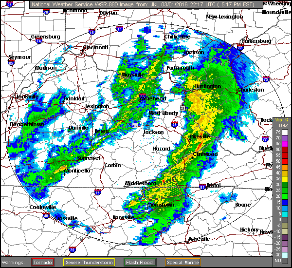
The focus this afternoon is on a squall line of strong-severe thunderstorms, with a history of wind damage, moving into the Kentucky foothills near the mountains.
JKL Doppler at 5:03 PM
Some loud thunder & lightning in Clintwood at 5:11 PM
JKL Doppler at 5:11 PMJKL Doppler at 5:14 PM
A 61 mph wind gust reported on Flatwoods Mountain, adjacent to Pine Mountain, near the Virginia-Kentucky stateline at 5:15 PM.
Flatwoods Mountain MesoNET Up To 5:30 PM
Blinding rain and strong winds in Clintwood at 5:22 PM
JKL Doppler at 5:17 PMJKL Doppler at 5:21 PMJKL Doppler at 5:24 PM
It has gotten dark like night with heavy rain and wind at 5:25 PM in Clintwood ( now into Norton-Wise ). Booming thunder with a lightning strike at 5:29 PM.
JKL Doppler at 5:28 PM
Another BOOM of thunder with vivid lightning at 5:32 PM.
High Knob Massif Webcam – University of Virginia’s College At WiseHigh Knob Massif Webcam – University Of Virginia’s College At WiseJKL Doppler at 5:31 PM
The line is weakening across the High Knob Massif area.
JKL Doppler at 5:34 PM
Wind damage has occurred in London, Ky., including buildings, trees, and at least 1 injury, with passage of this squall line.
JKL Dual-Pol Doppler at 4:52 PM
Warnings have expired in eastern Kentucky, currently, but the line continues to have a mini-waves indicative of strong winds.
This warning is no longer in effect.
Severe Thunderstorm Warning To 5:45 PMHigh Knob Massif Webcam – University Of Virginia’s College At Wise
Temperatures remain chilly atop the high mountains this afternoon with middle 40s. This means limited instability with dewpoints in mid 40s to lower 50s across the area.
Black Mountain MesoNET at 4:30 PM
However, momentum transfer of strong winds aloft will remain possible. ROARING winds will overspread the area tonight behind the cold front.
My Overnight Discussion
A simply lovely close to the month of February, and also Meteorological Winter, has given way to a cold and frosty night amid mountain valleys verses gusty conditions and “milder” temperatures atop mid-upper elevation ridges.
High Knob Massif Webcam – University Of Virginia’s College At Wise
It was 30.0 degrees exactly at my official Clintwood station at Midnight, with 31 degrees in Jonesville and Sandlick, verses a relatively balmy ( by contrast ) 46 degrees ( really 44 with the warm bias ) at Lonesome Pine Airport in Wise.
Colder mountain valleys were already in the 20s at Midnight, such that this large vertical temperature spread will increase into the overnight between valleys that remain decoupled ( detached from winds above ) from the flow field of the atmosphere and breezy-gusty mountain ridges & plateaus.
The main focus of this forecast period is on a dramatic weather change that will be developing between late this afternoon and Wednesday morning, with high-resolution models of the NAM group now coming into line with the more aggressive forecast of the European Model.
NAM 12 KM Model 850 MB Forecast At 7:00 PM Monday – March 1, 2016
Note too the 58+ mph low-level jet being shown along the front where isobars bend into a trough above over SE Kentucky. While winds will be gusty before the front, all locations will tend to develop ROARING winds into evening as much of that momentum mixes downward toward the surface along with increasing cross-barrier flow as barometric pressure begins adjusting across the Appalachian chain ( large pressure falls then rises tonight ) from northwest to southeast. A classic strong wind setting for a time later today into tonight. Any squall line with heavy rain will be amid this setting ( toward 5:00 PM, give or take an hour ). A squall line also implying that the heavy rain will tend to be limited in time ( good news for wet ground, yet downpours must always be respected in case they might linger over any given place for a little longer in time ).
To illustrate the change, the NAM Model predicts the 7:00 PM temp over Wise to be 48 degrees up at the summit level of the High Knob Massif. By 7:00 AM Wednesday ( below ) the air temperatures has plunged to 12 degrees at the High Knob summit ( a 36 degree drop which can be translated downward to Norton-Wise to mean temps that plunge from 50s to around 60 degrees this afternoon to 20-23 degrees by Wednesday morning ). This temperature drop is also forecast by the European Model ( increasing confidence ).
NAM 12 KM Model 850 MB Forecast At 7 AM Tuesday – March 2, 2016
Winds continue to be gusty, especially along mid-upper elevation ridges-plateaus, into Wednesday morning such that feels-like conditions will truly be dramatic relative to temperatures experienced for a time today.
Storm Prediction Center Risk Region For Today Into Tonight
Any time there is such a dramatic air mass change the risk for strong to locally severe thunderstorms often must be respected ( especially entering Meteorological Spring ).
Storm Prediction Center Risk For Wind Damage
The Cumberland Mountains remain on the fringe with a marginal risk being maintained for severe storms. The greatest severe threats ( as I had already noted earlier ) being for the possibility of damaging winds.
Storm Prediction Center Risk For TornadoesStorm Prediction Center Day 1 Discussion
Kentucky is at the center of the potential for at least brief spin-ups ( tornadoes ) today, west of the mountains, and it will be this activity that will need watching as it pushes eastward to the mountains during the afternoon.
HRRR Model Future Doppler Forecast At 4:00 PM Today – March 1, 2016
The 1:00 AM run of the HRRR Model has the squall line getting close to the Virginia-Kentucky border, west of Cumberland Gap, around 4:00 PM. So I have adjusted my timing for Norton-Wise upward to 5:00 PM ( give or take an hour ). This timing may still change and have to be updated later.
Stay tuned to NOAA Weather Radio for possible watches and/or warnings that might be needed today.