Heavy frost, with a freeze in colder valleys, will occur overnight into this morning. Increasing clouds with development of precip into Saturday morning will prevent frost.
Overnight Into This Morning
Mostly clear. Frosty in mountain valleys. Light winds generally less than 10 mph below 2700 feet. NW-N winds at 10-15 mph, with higher gusts, along upper elevation ridges. Temperatures varying from mid-upper 20s to lower 30s in colder valleys to the upper 30s to low-mid 40s ( mildest along mid elevation ridges and exposed plateaus ).
This Afternoon
Partly to mostly sunny with increasing cloudiness by late. Light NW-N winds generally less than 10 mph. Cool. Temps varying from mid-upper 40s at highest elevations in the High Knob Massif to the middle 50s to lower 60s.
Tonight Into Saturday Morning
Cloudy with a cold rain developing by morning. Winds shifting ENE-ESE at 5-15 mph, with higher gusts, along middle-upper elevation mountain ridges. Temperatures dropping into the 30s to low-mid 40s. Wind chill factors dropping into the 20s & 30s along highest ridges.
Rain will change to snow above 3200 feet elevation by around sunset Saturday, with snow level dropping to 2000-2500 feet by overnight into Sunday. The potential exists for several inches of snow at the highest elevations, with 1″ or less below 3000 feet. Stay tuned for later updates.
Weather Discussion ( March 17-18 )
A frosty start to Thursday occurred in mountain valleys across southwestern Virginia, with a MIN of 32 degrees being observed officially in Clintwood. Temperatures plunged into upper 20s in the coldest valleys to be in contrast with much milder readings along exposed mountain ridges at mid-upper elevations.
A similar setting will develop into this morning ( Friday ) but temperatures will be a few degrees colder in many places, with hard freezes and heavy frost widespread in valleys across Wise and Dickenson counties ( Indian Creek-Pound-Clintwood and the Norton-Tacoma-Coeburn corridors, as examples, will feature nearly continuous frost ( as seen on Thursday AM ).
Yellow Trout Lily Flared Out In Sun-Gusty Winds – March 17, 2016
Bright sunshine prevailed through much of the day before some late afternoon mid to high clouds rolled across. Combined with gusty winds the Trout Lilies were flared out and shaking all day, requiring substantial shutter speeds to stop the motion.
Polypore Fungi With Lichens & Moss In Late PM Light – March 17, 2016
One more nice day for your TGIF should be enjoyed before a nasty Palm Sunday weekend takes shape, with a cold rain developing into Saturday Morning. Saturday looks to be a raw, nasty day with precipitation changing to snow at the upper elevations ( above 3000 feet ) by around sunset.
GFS Model Total Snowfall Forecast ( Thursday AM Run )
Models continue to struggle with amounts and placement, except for general agreement for the bulls-eye of heaviest snow across eastern-northeastern West Virginia and extreme northwestern and northern Virginia ( up to 6″ or more at high elevations ).
GFS Model Total Snowfall Forecast ( Thursday Eve Run )
Locally, across the Mountain Empire, snowfall will be elevation biased with the most accumulations at the highest elevations where there still looks to be a chance for 2-3″+ above 3000 to 4000+ feet during the Saturday Night-Monday AM period.
NAM 12 KM Model Total Snowfall Forecast ( Thursday AM Run )
Even at these highest elevations, some melting will likely occur such that more snow will tend to fall than is ever on the ground at any given time ( given recent anomalous warmth during the past ten days ). Accumulations below 3000 feet will be restricted to night-time and early morning hours.
NAM 12 KM Model Total Snowfall Forecast ( Thursday Eve Run )
The NAM Model group wants to generate the best sticking during Sunday Night into Monday AM at elevations below 3000 feet, as moisture from the Great Lakes comes into the area on WNW to NW upslope flow. Any sticking Saturday Night into Sunday morning being mostly above 3000 feet, with the chance that snow levels will drop to 2000-2500 feet elevation by Sunday Morning.
The above scenario will need to be updated, with a better idea hopefully had by this time tomorrow night.
The Bottom Line – A frosty cold start in mountain valleys this morning will give way to one more nice day before a raw, nasty weekend settles into the mountain region for the Palm Sunday period.
*This includes the official astronomical beginning to spring; however, for climate purposes, Spring 2016 started with the arrival of March ( i.e., Meteorological Spring of March-May ).
Cold rain will develop into the overnight-morning hours of Saturday, with low clouds and wet, raw conditions during the day. It will feel especially chilly in wake of recent anomalously warm days.
Colder air begins overspreading the mountain area by the sunset-Midnight period of Saturday. Any precip lingering will change to snow above 3200 feet during Saturday evening, with snow levels dropping over time into Sunday morning for any moisture left.
Current uncertainty rests with how much moisture will be left for Saturday Night into Sunday morning, and if there may be a break before moisture wraps back into the mountains with Great Lake moisture transport by later Sunday into the early hours of Monday ( before ending ).
Any snow accumulations will be elevation biased, with heaviest amounts most likely above 3000-4000+ feet, with lighter amounts ( generally 1″ or less ) currently expected at elevations below 3000 feet ( mostly amid the 1500-3000 foot zone on the upslope side of the mountain chain with respect to WNW-NW flow ).
Stay tuned for updates, since this system is yet to develop and changes may still occur depending upon numerous factors ( such as storm track-strength ).
Please NOTE that 23 of the past 27 Aprils going back to 1989 have had measurable snow in upper elevations of the High Knob Massif ( before that, 4+ FEET of snow fell in April 1987 ). So please, let no one think this is anomalous. It is still only March!!!
Frost will be likely in colder mountain valleys into this morning, as well as tomorrow night into Friday AM when a more widespread coverage will be possible in valleys. Exposed mid-elevation sites, in typical thermal belts, are expected to remain frost free.
Overnight Into This Morning
Mostly clear. Cooler. W-NW winds decreasing to mostly less than 10 mph below 2700 feet. WNW winds 10-15 mph, with some higher gusts, on upper elevation ridges. Temps varying from the 30s in colder valleys to the lower-mid 40s. Wind chills in the 30s along upper elevation ridges.
This Afternoon
Partly to mostly sunny. W winds 5-15 mph, with higher gusts. Temperatures varying from the upper 40s at the highest elevations to the middle 50s to lower-mid 60s.
Tonight Into Friday Morning
Mostly clear into the overnight. Increasing high clouds toward morning. Frosty in mountain valleys. Light winds generally less than 10 mph below 2700 feet. NW winds at 10-15 mph, with higher gusts, along upper elevation ridges. Temperatures varying from upper 20s to low 30s in colder valleys to the upper 30s to low-mid 40s ( mildest along mid elevation ridges and exposed plateaus ).
A chance for accumulating snow continues to be monitored for the Palm Sunday Weekend ( centered on March 20-21 ). Prolonged sub-freezing temperatures are expected.
Weather Discussion ( March 16-17 )
Another very nice early spring day was observed across the mountain area Wednesday; albeit, gusty with a significant drying of the low-level air via efficient vertical mixing.
Spring Scene In The Cumberland Mountains – Late PM of March 16, 2016
The above scene is focused on Golden Ragwort ( Packera spp. ) whose green basal leaves are shown amid mosses, grasses, a few developing Dandelions, American Beech leaves, and other species.
Nora 4 SSE – NWS Site In The Middle Elevations
Afternoon temperature got somewhat warmer than I thought, especially at lower-middle elevations thanks to a boost from downsloping S-SW winds, with a large variation from the 50s at highest elevations in the High Knob Massif, 60s in Norton-Wise-Sandy Ridge, to the lower-middle 70s from Pound to Clintwood to Grundy.
Yellow Trout Lily ( Erythronium spp. ) In Fading PM Sun – March 16, 2016
The nearly unidirectional flow aloft, which enhanced vertical mixing and dried the air was key to getting air temperatures in downslope locations above 70 degrees.
This made 7 out of the past 9 days in Clintwood to officially rise above 70 degrees. The last day to do this until next week. Only 2 out of the past 9 days, by contrast, have broken 70 degrees within places above 2700 feet in elevation. No days on northern slopes amid upper elevations, above 3300 feet, have broke 70 degrees. The important off-setting factor for mountain valleys at lower-middle elevations being much cooler nights vs. middle elevation mountain ridges-plateaus.
As my climatology & nature journals show well, the above type of temperature distribution is key to the spring green up pattern featuring the fastest emergence of vegetation amid middle elevation thermal belt zones where MEAN air temperatures are warmer than locations above and below them ( the cooler valleys below them being due to colder nights, while the cooler elevations above thermal belts being due to both cooler days ( high ridges & lofty valleys ) and cooler nights ( especially in high valleys ).
Thermal Belts Have Been Recognized Since Native American Times
*The Wise and Sandy Ridge plateaus being classic examples of middle elevation thermal belt locations in this area, and long favored for orchards and other early-late season crops which depend upon a longer growing season ( i.e., frost sensitive ).
European Model 850 MB TEMP-Wind Forecast – 8 AM Today ( March 17 )
While temperatures will feel notably cooler today, they get much cooler and just down right cold from Saturday into Sunday-Monday ( especially ).
European Model 850 MB TEMP-Wind Forecast – 8 AM Sunday ( March 20 )
The flow is also northwesterly, such that any precipitation falling will have a chance to be frozen with some possible enhancement along the windward ( upslope ) side of the mountain chain.
*If this forecast verified it would cause temperatures to remain in the 20s during Sunday-Monday at elevations above 3000-3300 ft, with 30s across lower-middle elevations in the Cumberlands and low-mid 40s within locations downslope amid river valleys of the Clinch, Powell, Holston watersheds toward the Tri-Cities.
European Model 850 MB TEMP-Wind Forecast – 8 AM Monday ( March 21 )
More should be known by tonight into Friday as models continue to try and figure out this late season winter setting across the eastern USA.
European Ensembles 500 MB Height Anomaly Forecast – 8 AM March 23
As typical of March, a week from now the pattern flips again with warmer and wetter conditions ( showers and downpours in thunderstorms become possible ) looking likely by mid to late next week. Stay tuned.
Mostly clear in the evening with increasing clouds by morning. Becoming windy on mountain ridges-plateaus. Winds becoming SSW-SW at 10-20 mph, with higher gusts, below 2700 feet. SW-WSW winds 15-25 mph, with higher gusts, along upper elevation mountain ridges. Temps in the 50s to lower 60s, except dropping into the 40s to low 50s in mountain valleys that remain sheltered from gusty winds.
Sunrise Through Mid-Day
Mostly cloudy. Gusty. Chance of a shower, local thunder possible. SW winds shifting W at 10-20 mph, with higher gusts. Temperatures in the 50s to mid 60s ( dropping to around 50 degrees at High Knob Massif summit level ).
This Afternoon
Mostly sunny. Gusty. Winds W-WNW at 5-15 mph, with higher gusts. Temps varying from the low-mid 50s across upper elevations to the low-mid 60s, warmer south toward the Tri-Cities.
Tonight Into Thursday Morning
Mostly clear. Cooler. W-WNW winds decreasing to mostly less than 10 mph below 2700 feet. WNW winds 10-15 mph, with some higher gusts, on upper elevation ridges. Temps varying from the 30s in colder valleys to the lower-mid 40s. Wind chills in the 30s along upper elevation ridges.
A chance for accumulating snow continues to be monitored for the Palm Sunday Weekend ( centered on March 20-21 ). Stay tuned for updates on this system.
Weather Discussion ( March 15-16 )
Tuesday was a simply delightful day in the mountains, with large day to night temperature spreads now being observed amid mountains valleys ( from a MAX of 76 degrees temps have fallen to 45 degrees, as of 2:00 AM, here in Clintwood ).
Yellow Trout Lilies & Fruiting Moss In Late PM Light – March 15, 2016
Following showers & thunderstorms, which produced 0.54″ of rain during the past couple of days in Clintwood, the drying of air aloft was evident this afternoon with nice blue skies amid the Beeches.
American Beech ( Fagus grandifolia ) of Cumberland Mountains – March 15, 2016
Climb upward out of the deep mountain hollows and it is a mild and gusty night ( windy ) along mid-upper elevation mountain ridges & plateaus.
Black Mountain MesoNET Up To 1:15 AM – March 16, 2016
This is a rare March night when 20-30+ mph winds across high ridges are not accompanied by any substantial wind chill factors.
NAM 4 KM Model TEMP Forecast At 1:00 AM Wednesday – March 16, 2016
Even our highest resolution models can not pick up on the large vertical temperature differences occurring across our complex terrain, with large temp differences over short distances and within the lower 1000-2000 vertical feet of the atmosphere tonight ( as of 1:00 to 2:00 AM ).
HRRR Model 1:00 AM Initialization Temperatures
Following another fast moving morning cold front, with a chance for hit-miss showers and perhaps local thunder in a thin line along-ahead of the boundary, yet another very nice afternoon is expected today.
Mountain valleys are likely to turn frosty into Thursday morning, especially amid the colder locations, as winds calm and another inversion develops amid lower dewpoint air tonight.
European Ensembles Mean Sea Level Pressure Forecast – 8 AM March 19, 2016
Focus then shifts to a cooling trend and the Palm Sunday weekend system, which is looking a little weaker & a little farther east on its track.
European Ensembles Mean Sea Level Pressure Forecast – 8 AM March 20, 2016
The Ensemble MEAN snowfall forecast was still in the 2-3″ range for the Wise gridpoint, with variations from 0″ up to more than 6″ on the 51-Member group Tuesday ( 12z run ).
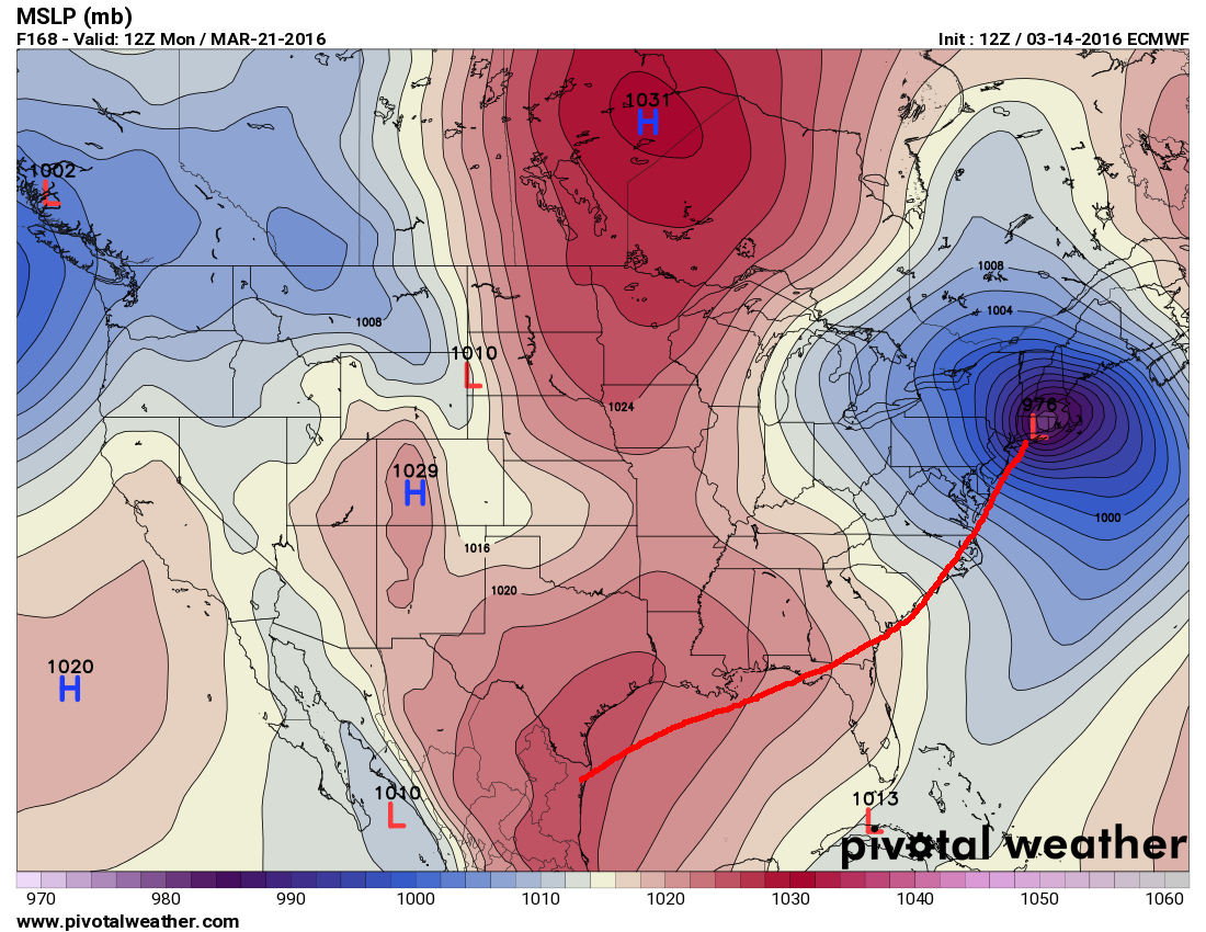
European Ensembles Mean Sea Level Pressure Forecast – 8 AM March 21, 2016
As always, check back for updates on this late winter-early spring weather system.
Cloudy with showers into the overnight, then decreasing. Areas of fog, especially at highest elevations. SW winds becoming W-WNW at 5-15 mph, with higher gusts, along middle-upper elevation mountain ridges and plateaus. Temperatures in the 40s to lower-middle 50s ( wind chill factors in the 30s at highest elevations ).
*Fog will become more widespread in nature should skies clear before sunrise.
Mid-Morning Through This Afternoon
Morning clouds & any fog giving way to sunny skies. Pleasant. Southerly winds at generally less than 10 mph. Temperatures varying from lower 60s to low-mid 70s, coolest at the highest elevations.
Tonight Into Wednesday Morning
Mostly clear in the evening with increasing clouds by morning. Becoming windy on mountain ridges-plateaus. Winds becoming SSW-SW at 10-20 mph, with higher gusts, below 2700 feet. SW-WSW winds 15-25 mph, with higher gusts, along upper elevation mountain ridges. Temps in the 50s to lower 60s, except dropping into the 40s to low 50s in mountain valleys that remain sheltered from gusty winds.
Air will turn colder by Friday, with a late season winter storm potential being monitored for Palm Sunday weekend-Monday during the March 19-21 period. Stay tuned for later updates.
Weather Discussion ( March 13-15 )
That March is a fickle weather month is no surprise, with some of the greatest storm events on record being observed during this month. From great blizzards ( March 1942 and March 1993 ) to destructive floods ( March 2002 ) and severe thunderstorms ( March 2012 ), this month can be amazing.
*It was 23 years ago today that the mountain area was just starting to dig out from Superstorm 1993. Snowfall totals reached 30″ in Wise, 34″ in Clintwood, and 46″ to 58″ amid upper elevations of the High Knob Massif ( snow drifts of up to 20-25 feet ).
Quarter Moon Through Budding Red Maple – March 13, 2016
So it should be no real surprise that this week begins with rain showers & thunderstorms, amid unseasonable warmth, and could end with cold air and snowflakes ( details yet to be worked out, but that is the clear trend on current runs ).
Yellow Trout Lily ( Erythronium spp. ) Open During Day
Native species, such as our ephemeral wildflower beauties, are adapted for such changes and even for those which can be significant between day and night ( Bloodroot, which has not yet bloomed, curls up as protection against cold nights ).
High Knob Massif Webcam – University Of Virginia’s College At Wise
Showers, hit-miss thunderstorms with downpours and local hail, and beautiful cloud formations were all part of changing weather conditions observed during Monday ( March 14 ).
High Knob Massif Webcam – University Of Virginia’s College At Wise
More changes are ahead this week as beautiful conditions today give way to increasing winds tonight ahead of the next system featuring a deep low over the Great Lakes.
European Model Mean Sea Level Pressure Forecast – 8 AM March 16, 2016
It is the late week period that will be drawing the most attention as low pressure moves across the Gulf and up along the Atlantic Coast. Track & intensity are yet to be determined, but the Monday MEAN of the 51-Member European Ensembles show an “interesting” potential.
European Ensemble MEAN Forecast Track From 12z Monday Run ( March 14 )
Despite unseasonable warmth in recent days, there will be plenty of cold air pouring in by the Palm Sunday Weekend when temperatures in the southern Appalachians could be approaching 20 degrees ( F ) below average for mid-March.
European Ensembles MEAN 850 MB TEMP Anomalies Forecast – 8 AM March 21
Any thunderstorms which may develop this weekend could possess heavy rainfall ( and always dangerous lightning ).
Saturday Morning To Afternoon
Continued mild with an abundance of clouds will be the main weather theme into today. Patchy areas of fog will remain possible overnight, with widespread temperatures in the middle 40s to middle 50s ( coolest in valleys along & north of the High Knob Massif-Tennessee Valley Divide ).
*A weak boundary pushed across the area with light showers and sprinkles during Friday. This allowed cooler air to bank up along and north of the High Knob Massif-Tennessee Valley Divide, with areas of fog at times, verses locations to the south ( still the entire region remained much warmer than average for March ).
While there will be a chance of afternoon showers, with local thunder if conditions become unstable enough, the day will feature many dry hours in most locations. Temps will warm into the 60s and 70s, varying from around 60 degrees at the High Knob Lookout to mid-upper 70s in warmer locations ( especially in main river valleys ). Expect light & southerly winds.
Saturday Night Into Sunday Morning
*Remember to SPRING FORWARD & Set Time Ahead 1-Hour
Cloudy & mild conditions continue with an increasing chance for showers, and possible thunder, during the predawn to post-sunrise period on Sunday. Winds will increase and be SSE-SW at 10-20 mph, with higher gusts, along mid-upper elevation mountain ridges. Temps will remain unseasonably warm with widespread readings in the 50s to middle 60s ( coolest at highest elevations ). Expect areas of fog to be possible.
Sunday Afternoon
The chance for showers, with possible thunder, continues into the afternoon. Mild conditions do as well with temps in the 60s to around 70 degrees for most places. Expect temps in the 50s at highest elevations in the High Knob Massif. Winds will be S-SW at 5-15 mph, with higher gusts.
Sunday Night Into Monday
The best chance for more significant rain, with possible thunder, will likely develop Monday. Meanwhile, a break will become likely after any Sunday PM-evening activity wanes. Expect gusty SSW-SW winds of 10-20 mph, with higher gusts, across mid-upper elevation ridges-plateaus during Sunday Night into Monday AM ( especially on mid-upper elevation mountain ridges ). Areas of fog will be possible in valleys. Temps will be widespread in the 50s, with 40s in cooler mountain valleys.
Updated: 2:00 AM Monday ( March 14, 2016 )
The Storm Prediction Center has issued a marginal risk for severe thunderstorms today, with the main threat being the potential for wind damage from the stronger storms.
Storm Prediction Center Risk Regions For MondayStorm Prediction Center Discussion
The HRRR Model future Doppler shows showers and storms overspreading southwestern Virginia and NE Tennessee this afternoon. Some of these could be strong to locally severe.
HRRR Model Future Doppler Forecast At 2:00 PM Monday – March 14, 2016
The HRRR Model is timing activity to overspread southwest Virginia and northeastern Tennessee between 2 to 4 PM.
This timing could, of course, vary a little, with the main idea being that showers and thunderstorms will be developing this afternoon across the Mountain Empire.
HRRR Model Future Doppler Forecast At 4:00 PM Monday – March 14, 2016
Weather Discussion ( March 11-13 )
Although a weak boundary pushed across the mountains during Friday, with abundant low clouds ( dense fog amid upper elevations of the High Knob Massif ) and a few light showers and sprinkles, temperatures remained above the average for this time of year ( coolest along-north of the High Knob Massif-Tennessee Valley Divide ).
Nora 4 SSE – Official NWS Station In Middle Elevations
PM temperatures varied from low-mid 50s in upper elevations of the High Knob Massif to upper 50s to lower 60s in Norton-Wise and Clintwood ( 62.6 degrees being the official PM MAX in Clintwood ).
Reflections In Rain Drops On A Spider Web Near Forest Floor
While my goal was to capture some more shots of Yellow Trout Lilies, as it ended up I found few blooms since it appeared that White-tailed Deer had been eating them about as fast as they emerged ( many lily leaves but no nice blooms ).
I found many more rain drops dangling amid spider webs near the forest floor than Lily blooms, thus the above photograph which is focused upon reflections of leaves and trees in the drops.
Sphagnum Moss Soaking Up The Moisture
A few other scenes of interest.
Polypore Fungi On A Dead Log ( The Polypore Overwintered On The Log )
The weather focus through this weekend remains on unseasonably warm air with a chance for some rain showers at times, and possible thunder if it becomes unstable enough. The European 9 KM Model continues showing the bulk of the most widespread activity remaining west of the mountains this weekend.
*As I noted in my 031116 Forecast discussion, a key factor will be the amount of instability which can develop. Rain and especially thunderstorms will remain more limited if the instability does not increase enough to support it ( periods of sunshine would help the atmosphere to become more unstable and increase activity ).
NAM 4 KM Model Total Rainfall Forecast To 7 AM Monday – March 14, 2016
The above is what the high-resolution NAM 4 KM Model is trying to show, with locally heavy rainfall and storms amid a region with much lighter amounts along the mountains. Placement of the heaviest rains, of course, being a model guess, with the displayed pattern being most important as it shows hit-miss convection with downpours.
European 9 KM Model 500 MB Height Anomalies Forecast – 8 PM March 14
A relatively weak disturbance will be moving across the area on Monday, with a stronger system expected by the middle of next week as the flow pattern begins to turn much cooler ( and eventually cold ).
European 9 KM Model 500 MB Height Anomalies Forecast – 8 PM March 16
Cloudy and gusty. Warm. A chance for rain showers or sprinkles. SW-WSW winds 10 to 20 mph, with higher gusts, across middle to upper elevation mountain ridges-plateaus. Temperatures widespread in the 50s and 60s ( coolest in the most sheltered mountain valleys and along highest ridges ).
Mid-Morning Through Friday Afternoon
A chance of rain showers or sprinkles into early PM. Mild. Winds shifting N-NE and decreasing to generally less than 10 mph ( becoming variable into late PM ). Temperatures in the 50s to middle 60s ( coolest at highest elevations ).
Tonight Into Saturday Morning
Mostly cloudy. Mild. A chance for showers developing into morning. Winds SSE-SW 5-15 mph, with higher gusts, by the overnight-morning along middle-upper elevation mountain ridges. Temperatures widespread in the 50s.
Weather Discussion ( March 10-11 )
The main change in my forecast, from the one made last night for tonight, is to reduce precipitation to a chance for rain showers or sprinkles as the mountain area is caught in a general subsidence zone ( with sinking air aloft ) north of heavy rain and thunderstorms over the Deep South.
So far, as of 2:00 AM, there has been just enough rain to dampen the ground in places. These rain showers and sprinkles, mostly light, will continue into this morning.
Regional Doppler At 11:38 PM on Thursday – March 10, 2016
Abundant clouds and gusty winds are keeping the air well mixed with only the most sheltered valleys dropping into the 50s to match the highest mountain ridges. The rest of the mountain area is basking in 60s ( like a summer night ).
The other main change on this update being to delay the passage of a weak cold frontal boundary until after sunrise, which will keep unseasonably warm conditions all night. Temperatures on your TGIF will be cooler than in past days, but still mild for this time of year ( coolest conditions today being along and north of the High Knob Massif, and at highest elevations, in far SW VA ).
Black Mountain MesoNET Up to Midnight
The abundance of clouds is helping hold heat from the past day, with a general subsidence or sinking air regime aiding this over the Mountain Empire which is north of drenching rain-thunderstorms over the Dixie States.
USA Water Vapor Image At 11:45 PM Thursday – March 10, 2016
The 73 degree record in Wise, established back on March 10 in 2009, will be in jeopardy once the official data comes in as air temperatures were right at that point on Thursday.
Nora 4 SSE – Official National Weather Service Site In Middle Elevations
The NWS Cooperative Site at Nora 4 SSE on Long Ridge of Sandy Ridge was right at 73 degrees during Thursday ( elevation of 2650 feet above sea level ). Temperatures at Lonesome Pine Airport in Wise are not official, with the official site for Wise being the NWS Cooperative located approximately 3 miles east of the Courthouse.
Thursday temperatures across the area in general varied from mid 60s atop the High Knob Massif, at highest sites, to upper 70s ( 78 degrees in Clintwood ). Readings at or above 80 degrees occurred within lowlands to the south, toward the Tri-Cities ( 82 degrees officially at TRI ).
NAM 12 KM Model Total Precipitation Forecast To 7 AM Monday ( March 14 )
The NAM Model group continues to show much more rain this weekend than the European Model, which is holding off on the most significant rainfall until early-middle parts of next week, and even later in time into the extended. A first test for this upgrade to see how it may handle this setting.
So far its been dead on target with excessive rain over the lower Mississippi Valley, with amounts reaching and even locally exceeding the 16.00″ or so it was predicting from 2-days ago. All models tend to struggle with total amounts when convection is involved ( which may be key to local amounts through this weekend…will it become unstable enough for any convection? Convection could cause locally heavy amounts. If not, then amounts may come in on the low end, like the latest ECMWF is showing in general ).
Reference my 031116 Extended Outlook for a look ahead at a pattern which will trend back to colder conditions during the second half of March 2016.
High altitude clouds. Gusty across mid to upper elevation mountain ridges & plateaus. SSW-SW winds increasing to 05-15 mph, with higher gusts, on exposed ridges-plateaus below 2700 feet. SW winds 10-20 mph, with higher gusts, across upper elevation ridges. Mild with widespread temps in the lower 50s to lower 60s on mid-upper elevation ridges and plateaus verses upper 30s to lower 40s in sheltered valleys protected from gusty winds.
This Afternoon
Mix of clouds and sun with an increasing cloudiness trend by late afternoon. Unseasonably warm. SSW-SW winds at 5-15 mph, with higher gusts. Temperatures varying from 60 to 65 degrees at highest elevations to the mid-upper 70s ( 70-75 degrees in Norton-Wise ).
Tonight Into Friday Morning
Cloudy & gusty into the early overnight. Warm. Showers, with a chance of thunder, developing by late evening into the overnight. SW-WSW winds 10 to 20 mph, with higher gusts, on mid-upper elevation mountain ridges-plateaus shifting NNW-N and decreasing to 5-15 mph by morning. Temperatures widespread in the 50s & 60s throughout the evening, dropping into mid-upper 40s to mid-upper 50s by morning ( coolest at the highest elevations ).
Weather Discussion ( March 9-10 )
I was able to get into the woods for a little while during the afternoon hours of Wednesday and found many Trout Lilies coming up, but only one or two beginning to bloom.
My nature journal shows that the first Coltsfoot and Trout Lilies started blooming in recent years during the following periods:
2015 Late March
2014 Mid-Late March
2013 Late March-Early April
2012 Late February-early March
2011 Early-Mid March
2010 Mid-Late March
Blooming times being dictated by weather conditions during any given year, with the scene below illustrating what it looked like one year ago Wednesday in the High Knob Lake Basin.
Snowpack In High Knob Lake Basin – March 9, 2015
A general 10″ to 15″ of snow depth, with 18″ to 30″ depths in places, were observed one year ago today in the High Knob Lake Basin in wake of a huge February 2015 snowpack ( this was part of a 14-day gush of water run-off ).
Anomalous warmth which developed in March 2012, and triggered devastating tornadoes in eastern Kentucky, got early wildflowers like Coltsfoot and Trout Lilies blooming earlier than this year. By contrast, a snowy-cold March in 2013 did not allow for blooming until late March into early April ( the latest observed since 2010 ).
Yellow Trout Lily ( Erythronium spp. ) In Bloom – March 9, 2016
Observe the nice red pollen that is on this plant from the stamens. A few early season insects were working, of course, the flower in unseasonable warmth on this day ( not record warmth here, but not far away either ).
Polypore Fungi which over-wintered are nice and white along a Cherry Birch ( Betula lenta ). These are the main fungi visible now as everyone waits for beloved Morel’s ( called Dry-land Fish in the mountains ) to emerge into mid-Spring.
A Hairy Polypore That Overwintered On A Cherry Birch – March 9, 2016
The weather focus tonight is on yet another vertical temp spread that is finding sheltered valleys with readings in the chilly 40s verses widespread 50s across mid-upper elevation mountain ridges and plateaus ( 60s in lowlands to the west and south of the Cumberland Mountains ).
Abundant mid-high clouds and mixing are making vertical temp differences smaller tonight, with 3:00 AM readings varying from 45 degrees here in Clintwood to upper 50s in Wise ( 51 degrees atop the High Knob Massif amid gusty SW winds ).
NAM 12 KM Model Precipitable Water Forecast – 1 AM Friday ( March 11 )
While an increase in moisture along a weak boundary will bring showers, with a chance of thunder, by late tonight into Friday morning, this boundary will stall and tend to wobble back and forth across the area to generate periods when showers will be possible ( but nothing like the fire hose of concentrated moisture that is flooding the lower Mississippi Valley with local 10-20″ rainfall amounts ).
Note how dry air northwest of the mountains ( above graphic ) settles south into the area ( below ) by Friday afternoon.
NAM 12 KM Model Precipitable Water Forecast – 1 PM Friday ( March 11 )
Moisture with the boundary returns north Friday Night into Saturday ( below ) with a chance for more rain showers.
NAM 12 KM Model Precipitable Water Forecast – 1 AM Saturday ( March 12 )
Drier air may then return by Saturday night into Sunday.
NAM 12 KM Model Precipitable Water Forecast – 1 AM Sunday ( March 13 )
I have used the precpitable water forecast charts, which I introduced to you in my 030916 Forecast, to illustrate how models are suggesting a weak boundary will wobble around the area with periodic chances for showers from tonight into this weekend ( but with many dry hours likely ).
European Ensembles MEAN 500 MB Height Anomalies Forecast For DAYS 1-5
It is the upcoming 5-10+ day period ahead, beyond the next 4 days, that I am looking at with most interest as this will be a period of change with progression of the western USA trough eastward.
European Ensembles MEAN 500 MB Height Anomaly Forecast – 8 AM March 19
There is increasing potential being shown for a much wetter, and eventually much cooler, pattern during the extended 5-10+ day period.
*Very preliminary rainfall estimates of 3.00″ to 5.00″+ are being forecast by the European Model along the Cumberland Mountains and Cumberland Plateau during the 5-10 day forecast period that is centered on the week of St. Patrick’s Day. A trend that will need to be closely followed in coming days using this 51-Member group.
A large vertical temperature spread, which is typical during much of the year in the mountains, will continue to be a prevalent factor tonight and again tomorrow night ( perhaps to a lesser degree by Wednesday Night into Thursday if wind speeds can increase enough to generate better vertical mixing ).
Overnight Into This Morning
Variable clouds ( intervals of high altitude cloudiness ). Gusty across mid to upper elevation ridges-plateaus. S-SW winds 5-15 mph, with higher gusts, below 2700 feet. Winds SSW-SW 10-20 mph, with higher gusts, on mountain ridges above 2700 feet. Temperatures varying from the 30s within colder mountain valleys to the upper 40s to middle 50s on exposed mid-upper elevation ridges-plateaus.
This Afternoon
Hazy sunshine & high clouds. Unseasonably warm. Winds S-SW 5-15 mph, with higher gusts. Temperatures varying from 60-65 degrees at upper elevations to the upper 60s to middle 70s ( coolest at highest elevations ).
Tonight Into Thursday Morning
High altitude clouds. Gusty across mid to upper elevation mountain ridges & plateaus. SSW-SW winds increasing to 10-20 mph, with higher gusts, on exposed ridges-plateaus below 2700 feet. SW winds 15-25 mph, with higher gusts, across upper elevation ridges. Mild with widespread temps in the lower 50s to lower 60s on mid-upper elevation ridges and plateaus verses upper 30s to lower 40s in sheltered valleys protected from gusty winds.
Showers, with a chance for thunderstorms, will become likely Thursday Night into Friday. Local downpours may be possible.
Weather Discussion ( March 8-9 )
Although pollen like this is not yet being generated, neither are such flowers, there is and will be increasing amounts of pollen from maple, willow, and various other species in the air during this unseasonably warm spell of early spring.
Loading Up With Pollen – Cultivated Coreopsis – May 2015
Pollens which actually can not be seen with the naked eye are the ones which tend to cause most of the misery to those who suffer.
Strong temperature inversions, with cold air drainage into mountain valleys, tend to hold back the pollen season some in the mountains ( as it does along chillier upper elevation ridges ) if you live in these naturally cooler locations.
Thermal belt sites, with colder air beneath them ( especially at night ) as well as above them, are the most favored places for surges of early season pollination. In this area thermal belts are typically found upon middle elevation ridges and plateaus at elevations somewhere between 2000-3000 feet.
As I have written about many times in the past, pioneers were the first to discover thermal belts in the mountains and quickly began locating orchards and other frost sensitive crops in these sites. I will have much more on such microclimatology in weeks ahead.
Focus now shifts to a slowly increasing moisture regime with models showing a significant spike upwards in total water amid the atmosphere by Thursday Night into Friday.
NAM 12 KM Model Precipitable Water Analysis At 7 PM Tuesday ( March 8 )
The precipitable water value above the Wise gridpoint at 7:00 PM Tuesday was only 0.30″ on the NAM 12 KM Model analysis. That means if all the moisture between the surface and top of a vertical column were to be precipitated out it would generate a depth of 0.3″ on the surface.
We can judge the amount of water in the atmosphere by using a quantity known as precipitable water, which is a measure of all the moisture in a vertical column between the surface and upper troposphere ( if precipitated directly out the depth of this water on a surface would identically equal the PW value ( Precipitable Water value ) ).
NAM 12 KM Model Precipitable Water Forecast At 1:00 AM Friday ( March 11 )
Computer models can quickly calculate these values by using calculus & integrating the dewpoint ( or saturation mixing ratio ) between the surface and top of the troposphere ( where moisture typically becomes a minimum ). Integration, of course, yielding by definition a summation whose value = the PW value for any given vertical column of air above a given gridpoint or interpolated point amid the larger-scale forecast grid.
The NAM 12 KM Model ( above ) predicts a rather dramatic increase in PW values between now ( very dry air ) and late Thursday into Friday morning when values rise to around 1.50″ ( moderately high for any given time of year ).
While PW values are always important, they also need to always be looked at with respect to mean climatological values for the time of year.
For example, mean monthly PW values for March between the surface and 500 MB are roughly around 1.20″ ( closer to 1.00″ during early March ). So if a 1.50″ PW value develops into early Friday it will be approximately 20% to 30% above average for this time of year.
By comparison, the current PW values at 7:00 PM Tuesday was only 25% to 30% of average for this time of year ( approximately 4 times below average for early March ).
NAM 12 KM Model MSLP and 1000-500 MB Thickness Forecast – 1 AM Friday
Another forecast factor I like to look at is the thickness of the atmosphere between the surface and 500 MB. Heavy rain often has a preferred thickness range within which climatology shows that it tends to fall during any given time of year. Early March preferences for this mountain region being roughly around 556 dkm ( +/- ) 5 dkm.
In other words, the vertical depth of the atmosphere between the surface and 500 MB tends to be around 5,560 meters give or take some 500 meters ( 551 to 561 dkm ). The forecast above by 1 AM Friday is a little higher than the preferred thickness here, at around 565 dkm or 5,650 meters ( by contrast, the thickness predicted over Arkansas is within the preferred range ).
NAM 12 KM Model Total Rainfall Forecast – Up To 7 AM Saturday ( March 12 )
Looking strictly at the above, one might say that rainfall will become likely ( with local downpours possible ) but not yet within the preferred range for widespread heavy rain. Remembering, most importantly, the above is a forecast and this will need to be followed and adjusted accordingly as time for rain to occur gets closer.
The latest European 9 KM Model run is keeping the bulk of heavier rain well to the north and west of the Mountain Empire through Saturday Morning. A trend to follow.
There are many other factors that forecasters should look at to form the complete picture, with the above being only a glimpse into how moisture values should be considered.
***An important note is that when convection is able to form it can compensate for lower PW values, at any given point or time, via inflow which tends to concentrate PW values and increase them over localized areas ( thus greatly complicating what might seem to be a rather clear-cut way of forecasting rainfall intensity ). Superimposed upon a boundary or favorable topography adds more layers to this “rainfall equation.”
Mid-high altitude clouds. Large vertical temperature spread between cold valleys and windy mountain ridges and plateaus. SW winds 10-20 mph, with higher gusts, below 2700 feet. SW-WSW winds 15-25 mph, with higher gusts, on mountain ridges above 2700 feet. Temperatures varying from upper 20s to lower 30s in colder mountain valleys to the upper 40s to middle 50s on exposed middle-upper elevation ridges & plateaus. Wind chills in the 30s and 40s ( coldest along high elevation ridges ).
This Afternoon
Hazy sunshine through high altitude clouds. Warm. Winds SW-SSE at 5-15 mph, with some higher gusts. Temperatures varying from mid-upper 50s in upper elevations to the mid 60s to around 70 degrees.
Tonight Into Wednesday Morning
Variable clouds ( intervals of high altitude cloudiness ). Gusty across mid to upper elevation ridges-plateaus. S-SW winds 5-15 mph, with higher gusts, below 2700 feet. Winds SSW-SW 10-20 mph, with higher gusts, on mountain ridges above 2700 feet. Temperatures varying from the 30s within colder mountain valleys to the mid-upper 40s to low-middle 50s on exposed mid-upper elevation ridges-plateaus.
Weather Discussion ( March 7-8 )
The first true signs of the spring season are slowly starting to emerge amid the mountain area, with increased singing of birds, choruses of frogs, and a few wildflowers.
Coltsfoot ( Tussilago farfara ) On UVA-Wise Campus – March 7, 2016
I found the first Coltsfoot poking up through the leaves near the UVA-Wise Wetlands, during late on Monday afternoon, amid nice songs from male Red-winged Blackbirds ( Agelaius phoeniceus ).
Late Afternoon Reflections Upon UVA-Wise Wetlands – March 7, 2016
The UVA-Wise Wetlands are part of a restoration project designed to capture, filter, and clean acid mine drainage before it enters the main watershed draining into the Clinch River.
Running-cedar ( Diphasiastrum spp. ) In Woods Near UVA-Wise Wetlands
Weather conditions Monday were certainly much different from that observed Saturday, when big flakes of snow fell and covered highest elevations in the High Knob Massif. I caught only a few good scenes in between showers of snow and snow-sleet.
Looking Across Proposed Cut-Burn Area of Clear Creek Basin – March 5, 2016
The U.S. Forest Service is proposing a large burn ( 1122 acres ) and timber cut that will impact 50% of the 7464 acres stretching across the Clear Creek, Machine Creek, Burns Creek, and a small part of the Mill Creek basins in the High Knob Massif.
Looking Across Large Clear Creek Basin In Proposed Burn-Cut Area – March 5, 2016
Some blemishes in the photographs are actually flakes of snow, as I captured a few images in between the showers of heavier snow.
U.S. Forest Service Proposed Burn-Cut Area on Pickem Mountain – March 5, 2016
The understory is rather lush in portions of the proposed burn.
U.S. Forest Service Proposed Burn-Cut Area on Pickem Mountain – March 5, 2016
Since everyone owns this land, everyone is encouraged to voice their opinions on this large burn and timber cut proposal.
Portion Of Proposed Burn-Cut Area On Pickem Mountain – March 5, 2016Pine Snags Killed By Beetles In Proposed Burn-Cut Area on Pickem Mountain
The weather focus tonight is on another large vertical spread in temperatures between cold, frosty valleys and gusty mid-upper elevation mountain ridges & plateaus.
Temperatures at 4:00 AM varied from upper 20s to lower 30s in colder valleys to the 50s on gusty middle elevation ridges.
European 16 KM Model 850 MB TEMP-Surface Analysis – 7 PM Monday
The big news in the weather world today is the introduction of a major upgrade to the Integrated Forecast System, called the European Model. The 12z Model Run this morning will be the first to publicly show this new upgraded package.
The statistically best medium range forecast model on the planet will be getting better according to testing preformed during the past few months on this new upgrade that will take the resolution down to 9 KM ( from 16 KM ) for the operational global group. The unique 4-D system will utilize a octahedral reduced Gaussian grid, which will make running the model less costly while conserving general efficiency ( according to released testing results ).
The coming months should prove interesting as all eyes focus on how this new upgrade preforms under the rigors of daily global weather forecasting. I will be most interested in watching if it will be able to better resolve the orographics and patterns which are specific to the Appalachian Mountains ( verses the current ).
European 16 KM Model 850 MB Wind Field Analysis – 7 PM Monday
*Mathematical statistics verify that the European Model has been the best medium range model for decades. Although it struggles, like all models, at times the mathematics do not lie and clearly show that the 4-Dimensional System used by this model has been superior to all other models, especially for locations dealing with baroclinicity at middle to high latitudes.
Meanwhile, a mild weather pattern will dominate this week with abundant clouds at high altitudes that will trend lower by late week into this weekend-next week as moisture will be increasing & eventually producing showers-storms.
ALERT For Dense Fog & Freezing Fog At Mid-Upper Elevations Along & North Of The High Knob Massif Tonight Into Sunday AM – Mainly Above 2700 Feet
Some freezing fog coated higher elevations around Norton-Wise into Saturday morning, with another round of dense fog expected to develop overnight into Sunday morning with freezing levels at the 2000 to 2500 feet elevation by morning ( new models tonight have lowered the freezing level by a few hundred vertical feet ) as deep northerly flow develops into Sunday morning. This will also support some snow showers across upper elevations and drizzle and/or freezing drizzle-snow-mix at middle elevations and just drizzle at lower elevations ( mainly north of High Knob Massif ).
*This will develop on northerly upslope flow with downslope sites mainly having dry and mostly cloudy conditions.
New Snow Accumulation Saturday PM on Eagle Knob – March 5, 2016
*Snow fell hard, with big flakes, between 3:00 to 4:00 PM and covered roads at highest elevations for a time before melting some, as the temperature hovered between 32 to 33 degrees.
While a rain-snow mixture fell in Norton-Wise during Saturday afternoon, mostly all snow fell at summit levels of the High Knob Massif with around 0.5″ accumulating on Eagle Knob through late afternoon ( new snow accumulation shown above ). Tonight very dense fog ( freezing fog ) has settled into the high country with dropping cloud bases expected into middle elevations after Midnight into Sunday morning. Slow down and take it easy.
Saturday Forecast
Mostly cloudy skies overnight will carry into this morning, with some breaks possible. This has allowed dense fog to develop with temperatures below freezing. Light northerly winds will shift SW-SSW by morning on middle to upper elevation ridges and will eventually help dissipate the fog.
Any sunshine will be limited today as mid to high altitude clouds begin increasing in advance of the next fast moving system. Morning temperatures in the 20s to near 30 will have a chance to rise into the 40s across much of the area before afternoon rain showers develop. The exception will be at higher elevations in the High Knob Massif where 30s prevail, with snow or a rain-snow mix being possible there.
*As it turned out sleet & snow, with a little rain mixed, fell in the 3000-3500 foot elevation zone with nearly all snow above 3500 ft.
Saturday Night Into Sunday Morning
Eagle Knob of High Knob Massif at 11:00 PM – March 5, 2016
Following late afternoon-early evening melting off roads, it took little time for snow to recover roadways at high elevations in the High Knob Massif during Saturday Night with another burst of heavy snow ( with riming in clouds and temps in the 20s on N winds producing wind chills as cold as the low-mid 10s ).
Winds will shift NW-NNE behind a cold frontal passage on Saturday evening, with rain showers becoming mixed with or changing to snow in middle elevations, and all snow at upper elevations. Any snow accumulations, with up to 2″, look to be mostly above 2700-3300 feet in elevation.
A lowering of cloud bases will need to be watched for overnight into Sunday morning on northerly upsloping winds of 5-15 mph, with higher gusts, across mid-upper elevation mountain ridges-plateaus ( in typical locations along and north of the High Knob Massif and Tennessee Valley Divide…such as Wise, Sandy Ridge and adjacent communities which typically have dense upslope fog ).
Freezing fog will be possible at elevations above 2700 feet, with drizzle-freezing drizzle and/or some snow-mix at the lower-middle elevations and snow showers above 3000 ft.
Mid-Morning Sunday Through Sunday Afternoon
Cloud bases are expected to lift and drier air is currently predicted to overspread the area into the afternoon with skies becoming sunny to mostly sunny.
Winds will become light and temperatures should rise into the 40s to low-mid 50s ( upper 30s to lower 40s over a little snow at highest elevations in the High Knob Massif ).
Sunday Night Into Monday Morning
Some mid-high clouds will be possible as winds will be shifting SSE-SW at 5-15 mph, with higher gusts, across middle-upper elevation mountain ridges & plateaus.
This wind shift marks the beginning of a long awaited warming trend, with temperatures rising at highest elevations overnight into Monday morning.
*Due to an increase in wind chills, this initial warming will not really be felt along mountain ridges ( that comes next week ).
Updated at 9:45 PM on Sunday – March 6, 2016
A large vertical temperature spread, as I originally expected, will develop through tonight into Monday morning with readings varying from frosty, cold 20s within mountain valleys to upper 30s & 40s across exposed mountain ridges & plateaus ( where the off-setting factor will be an increase in wind chills, especially amid upper elevations where SSE-SSW winds are already gusty ).
Weekend Summary
Seasonably cold conditions will continue to be felt through most of this weekend before a prolonged warming trend develops next week.
Clouds will remain abundant through Sunday AM, with another fast moving disturbance expected to spread rain and snow showers across the area from Saturday afternoon into Saturday night.
Any sticking snow is likely to be restricted to highest elevations, above 3300 feet in elevation ( dusting up to 2″ or so will be possible at these highest elevations ).
A period where cloud bases will drop needs to be respected by the Midnight-Sunrise period Sunday, when northerly upslope flow will develop.
A period of dense fog, with freezing fog above 2700 feet, will become possible at mid-upper elevations along and north of the High Knob Massif during a period between 10 PM Saturday & 10 AM Sunday.
The elevation of cloud bases ( dense fog ) and the freezing level will need to be updated later as this period gets closer in time.
The main idea being that cloud bases will drop again on upslope flow during late Saturday evening into Sunday morning, with riming and dense fog at upper elevations along and north of the High Knob Massif-Tennessee Valley Divide which may drop into middle elevations ( below 3000 feet ) for a period of time.
Cloud bases are expected to lift and finally dissipate to produce mostly sunny to sunny skies into Sunday afternoon. This will allow temperatures to rise into lower-middle 50s in milder locations, with 40s most likely across upper elevations ( coolest over snow at highest elevations and northern slopes within the High Knob Massif ).
A large vertical temperature spread will be likely to develop Sunday Night into Monday morning as winds shift southerly to begin a long awaited and prolonged warming trend. This will be indicated first at highest elevations where temperatures will tend to rise, after any initial evening declines, overnight into Monday. Mountain valleys, by contrast, will have temp drops and develop much colder conditions than breezy to gusty ridges ( the offsetting factor for high ridges being an increase in wind chills into Monday AM ).
Extended Look At Next Week
An unseasonably warm period of weather, via a major shift in the upper air flow regime across the USA, is on tap for next week. Eventually, this will include rises in humidity-dewpoint ( moisture ) levels and showers-thunderstorms ( by late next week-next weekend ).
European Ensembles MEAN 500 MB Height Anomalies: DAYS 1-5
The eastern USA trough is going to be replaced by ridging as the western ridge breaks down and gives way to troughing.
European Ensembles MEAN 500 MB Height Anomalies: DAYS 6-10
This will bring needed precipitation to California and will set up a pattern featuring an excessive rainfall potential across the Lower Mississippi Valley. The eastward extent initially being blocked by ridging in the Atlantic; however, over time this will likely give way enough to allow for rains to move into the Ohio-Tennessee valleys and Appalachians.
European Ensembles MEAN 850 MB TEMP Anomalies: DAYS 1-5
This will be such a warm period that it should trigger the first woodland wildflowers of the season to emerge, if not already in milder locations outside the mountains, such as Coltsfoot ( Tussilago farfara ) and Trout Lily ( Erythronium americanum ), along with a few other species. Enjoy.
European Ensembles MEAN 850 MB TEMP Anomalies: DAYS 6-10
For those who suffer from pollen, it should also begin to increase some early tree pollens ( such as maples and the willows ) at lower-middle elevations.